External links
| International | |
|---|---|
| National | |
| Academics | |
| Other | |
David S. G. Thomas is a British scientist and geographer. He was born at his parents' home in River, near Dover, Kent, UK, in October 1958. He is Professor of geography at the University of Oxford, the fifth person to hold the Statuary Chair, and a Professorial Fellow of Hertford College, Oxford.
His research deals with desertification, dryland environments, climate change and other environmental phenomena. Recent research has focussed on desert geoarchaeology, dryland bioenergy and long-term environmental change in deserts. He received his D.Phil. from the University of Oxford. Between 1984 and 2004 he taught and researched at the University of Sheffield, where he rose from lecturer to senior lecturer then full professor by 1994, and was head of department. he has authored many scientific papers (over 200 by 2022) and 11 books including second and third editions. He has been vice-president of the Royal Geographical Society (twice) and president of the British Geomorphological Research Group (now British Society for Geomorphology. His research interests have seen significant activity in Africa, especially in the Kalahari and Namib Deserts and surrounding areas, and in Arabia and India.
In 2011 he received the Farouk El-Baz Award from the Geological Society of America for his contributions to desert science.
He received the Royal Geographical Society's Victoria Medal in 2018 for his world-leading research in desert environments and desert societies.
Amongst his many professional roles, he chaired the Geography and Environmental Studies for the UK's Research Excellence Framework (REF) 2021 from 2017 to 2022.
| International | |
|---|---|
| National | |
| Academics | |
| Other | |

Desertification is a type of gradual land degradation of fertile land into arid desert due to a combination of natural processes and human activities.

Erosion is the action of surface processes that removes soil, rock, or dissolved material from one location on the Earth's crust and then transports it to another location where it is deposited. Erosion is distinct from weathering which involves no movement. Removal of rock or soil as clastic sediment is referred to as physical or mechanical erosion; this contrasts with chemical erosion, where soil or rock material is removed from an area by dissolution. Eroded sediment or solutes may be transported just a few millimetres, or for thousands of kilometres.

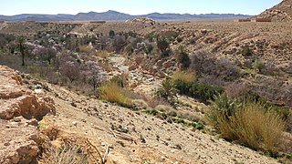
The Kalahari Desert is a large semi-arid sandy savanna in Southern Africa extending for 900,000 square kilometres (350,000 sq mi), covering much of Botswana, as well as parts of Namibia and South Africa.

Geomorphology is the scientific study of the origin and evolution of topographic and bathymetric features generated by physical, chemical or biological processes operating at or near Earth's surface. Geomorphologists seek to understand why landscapes look the way they do, to understand landform and terrain history and dynamics and to predict changes through a combination of field observations, physical experiments and numerical modeling. Geomorphologists work within disciplines such as physical geography, geology, geodesy, engineering geology, archaeology, climatology, and geotechnical engineering. This broad base of interests contributes to many research styles and interests within the field.
Deserts and xeric shrublands are a biome defined by the World Wide Fund for Nature. Deserts and xeric shrublands form the largest terrestrial biome, covering 19% of Earth's land surface area. Ecoregions in this habitat type vary greatly in the amount of annual rainfall they receive, usually less than 250 millimetres (10 in) annually except in the margins. Generally evaporation exceeds rainfall in these ecoregions. Temperature variability is also diverse in these lands. Many deserts, such as the Sahara, are hot year-round, but others, such as East Asia's Gobi Desert, become quite cold during the winter.
Nick Middleton is a British physical geographer and supernumerary fellow of St Anne's College, Oxford. He specialises in desertification.

Desert ecology is the study of interactions between both biotic and abiotic components of desert environments. A desert ecosystem is defined by interactions between organisms, the climate in which they live, and any other non-living influences on the habitat. Deserts are arid regions that are generally associated with warm temperatures; however, cold deserts also exist. Deserts can be found in every continent, with the largest deserts located in Antarctica, the Arctic, Northern Africa, and the Middle East.
The year 2006 was declared the International Year of Deserts and Desertification by the United Nations General Assembly. The Year aims to raise $20 million from industry and governments and will spend half on co-funding research, and half on "outreach" activities. It will be the biggest ever international effort to promote the Earth sciences. Apart from researchers, who are expected to benefit under the Year's Science Programme, the principal target groups for the Year's broader messages are:
Andrew Shaw Goudie is a geographer at the University of Oxford specialising in desert geomorphology, dust storms, weathering, and climatic change in the tropics. He is also known for his teaching and best-selling textbooks on human impacts on the environment. He is the author, co-author, editor, or co-editor of forty-one books and more than two hundred papers published in learned journals. He combines research and some teaching with administrative roles.
Sir Ronald Urwick Cooke, FRGS DL is a professor of geography and geomorphology who was vice-Chancellor of the University of York from 1993 to 2002.
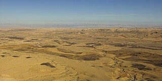
A desert is a landscape where little precipitation occurs and, consequently, living conditions create unique biomes and ecosystems. The lack of vegetation exposes the unprotected surface of the ground to denudation. About one-third of the land surface of the Earth is arid or semi-arid. This includes much of the polar regions, where little precipitation occurs, and which are sometimes called polar deserts or "cold deserts". Deserts can be classified by the amount of precipitation that falls, by the temperature that prevails, by the causes of desertification or by their geographical location.
Michael Mortimore was a British geographer and a prolific researcher of issues in the African drylands. He was an academic in Nigerian universities for over 25 years. He ran a British research consultancy, Drylands Research. He is best known for an anti-Malthusian account of population-environment relationships, More People, Less Erosion, and field-based studies of adaptation to drought.
Andrew Warren is a British physical geographer. He is Emeritus Professor of Geography at University College London, UK.

Land, also known as dry land, ground, or earth, is the solid terrestrial surface of Earth not submerged by the ocean or another body of water. It makes up 29.2% of Earth's surface and includes all continents and islands. Earth's land surface is almost entirely covered by regolith, a layer of rock, soil, and minerals that forms the outer part of the crust. Land plays an important role in Earth's climate system, being involved in the carbon cycle, nitrogen cycle, and water cycle. One-third of land is covered in trees, another third is used for agriculture, and one-tenth is covered in permanent snow and glaciers. The remainder consists of desert, savannah, and prairie.

Lindsay C. Stringer is a Professor in Environment and Development at the University of York.
Alfred Thomas Grove, known more commonly as Dick Grove, was a British geographer and climatologist. He was Emeritus Fellow of Downing College, Cambridge and a Director of the Centre of African Studies at the University of Cambridge. Grove researched Environmental Issues and Policy and the landscape change in southern Europe and Climate change and desertification with a focus on Africa and southern Europe. He was awarded the Busk Medal in 1982 for his field work in Africa.
Paul A. Shaw is a physical geographer and a Fellow of the Royal Geographical Society.
Caroline King-Okumu is an international development opportunities manager for the UK Centre for Ecology and Hydrology. She was formerly a senior researcher for the International Institute for Environment and Development (IIED). Her major areas of research are dryland ecosystems, economic and environmental assessment, and climate change. She is considered an international expert on land and water management, particularly drylands agriculture. King-Okumu is based in Kenya but is involved in research and projects throughout the world.
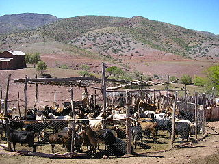
Desertification in Africa is a form of land degradation that involves the conversion of productive land into desert or arid areas. This issue is a pressing environmental concern that poses a significant threat to the livelihoods of millions of people in Africa who depend on the land for subsistence. Geographical and environmental studies have recently coined the term desertification. Desertification is the process by which a piece of land becomes a desert, as the word desert implies. The loss or destruction of the biological potential of the land is referred to as desertification. It reduces or eliminates the potential for plant and animal production on the land and is a component of the widespread ecosystem degradation. Additionally, the term desertification is specifically used to describe the deterioration of the world's drylands, or its arid, semi-arid, and sub-humid climates. These regions may be far from the so-called natural or climatic deserts, but they still experience irregular water stress due to their low and variable rainfall. They are especially susceptible to damage from excessive human land use pressure. The causes of desertification are a combination of natural and human factors, with climate change exacerbating the problem. Despite this, there is a common misconception that desertification in Africa is solely the result of natural causes like climate change and soil erosion. In reality, human activities like deforestation, overgrazing, and unsustainable agricultural practices contribute significantly to the issue. Another misconception is that, desertification is irreversible, and that degraded land will forever remain barren wastelands. However, it is possible to restore degraded land through sustainable land management practices like reforestation and soil conservation. A 10.3 million km2 area, or 34.2% of the continent's surface, is at risk of desertification. If the deserts are taken into account, the affected and potentially affected area is roughly 16.5 million km2 or 54.6% of all of Africa. 5.7 percent of the continent's surface is made up of very severe regions, 16.2 percent by severe regions, and 12.3 percent by moderate to mild regions.