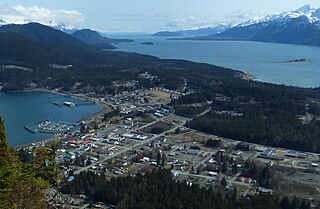
Haines is a census-designated place located in Haines Borough, Alaska, United States. It is in the northern part of the Alaska Panhandle and near Glacier Bay National Park and Preserve. As of the 2020 census, the population of the Haines CDP was 1,657, down from 1,713 in 2010; it has 79.6% of Haines Borough's total population.
The Chilkat River is a river in British Columbia and southeastern Alaska that flows southward from the Coast Range to the Chilkat Inlet and ultimately Lynn Canal. It is 84 kilometres (52 mi) long. It begins at Chilkat Glacier, in Alaska, flows west and south in British Columbia for 27 kilometres (17 mi), enters Alaska and continues southwest for another 60 kilometres (37 mi). It reaches the ocean at the abandoned area of Wells, Alaska and deposits into a long delta area.

The Dalton Trail is a trail that runs between Pyramid Harbor, west of Haines, Alaska in the United States, and Fort Selkirk, in the Yukon Territory of Canada, using the Chilkat Pass. It is 396 km (246 mi) long.

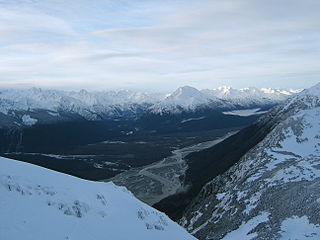
The Takhinsha Mountains are a mountain range in Haines Borough and the Hoonah–Angoon Census Area in the U.S. state of Alaska, in the southeastern part of the state. They extend 40 km (25 mi) west-northwest from the northern end of the Chilkat Range to the head of Riggs Glacier, 46 km (29 mi) southwest of Skagway.

The Chilkat Range is a mountain range in Haines Borough and the Hoonah-Angoon Census Area in the U.S. state of Alaska, west of the city of Juneau.

Miles Lake is a 3.5 miles (5.6 km) long glacial lake in the U.S. state of Alaska. It is located in the valley of the Copper River, which pools to create it. The lake includes the terminus of Miles Glacier, 33 miles (53 km) north of Katalla, Chugach Mountains, and flows into the lower Copper River (Alaska).
Chilkat Inlet is an inlet in Lynn Canal in the Southeast region of the U.S. state of Alaska that includes the delta for the Chilkat River and borders Haines and the Chilkat Peninsula. It was first charted in 1794 by Joseph Whidbey, master of HMS Discovery during George Vancouver's 1791–1795 expedition.

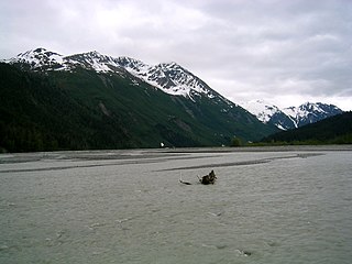
The Klehini River is a large, glacially fed stream in the vicinity of Haines in the U.S. state of Alaska.

The Alaska Chilkat Bald Eagle Preserve is a state park and wildlife refuge in the U.S. state of Alaska near Haines. Established in 1982, the park covers 49,320 acres (199.6 km2), mainly along the Chilkat River, with sections along the Klehini and Tsirku rivers.
The Endicott River is a stream, 25 miles (40 km) long, in Haines Borough in the U.S. state of Alaska. Beginning at the base of an unnamed glacier near Mount Young in the Chilkat Range, it flows generally eastward into the Lynn Canal. Most of the river's course lies within the Endicott River Wilderness of the Tongass National Forest. The river mouth is about 25 miles (40 km) northwest of Juneau.
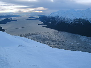
The Tsirku River is a glacier-fed stream in Southeast Alaska near the town of Haines in the U.S. state of Alaska. The river's source is found at the Tsirku Glacier, a large, sprawling ice mass at the border of Alaska and the Canadian province of British Columbia. The river ends in a 4-mile (6 km) wide delta near the Tlingit village of Klukwan. While many of the feeding glaciers are primarily in British Columbia, the river course lies entirely in Alaska.
Geikie Glacier flows northeast to Mercer Bay, at the southwest end of Cumberland West Bay, South Georgia. It was first charted by the Swedish Antarctic Expedition, 1901–04, under Otto Nordenskiöld, who named it after Sir Archibald Geikie, a noted Scottish geologist and Director-General of the Geological Survey of Great Britain, 1882–1901.
The Tsirku Glacier is a large icefield in the Saint Elias Mountains, spanning the border between British Columbia and Alaska, to the south of the Jarvis Glacier. It is the source of the Tsirku River, which flows northwest to become the second-largest tributary of the Chilkat River. GNIS gives its head at 59°17′00″N136°47′00″W and describes it as flowing across the Canada–US border one mile west of the head of the Tsirku River.
Chilkat or The Chilkat, or Chilkats, may refer to:

Muir Inlet is an inlet in Glacier Bay in Alaska in the United States. Muir Inlet heads in Muir Glacier, and extends for 48 kilometers (30 mi) south to Glacier Bay, 51 miles (82 km) northwest of Hoonah, Alaska. Muir Inlet is separated from Chilkat Inlet and Lynn Canal by the Chilkat Range. Muir Inlet has several glaciers' termini in addition to that of Muir Glacier; most prominent among them are Casement Glacier, McBride Glacier, and Riggs Glacier. In the west lies Wachusett Inlet and in the east Adam's Inlet.
Casement Glacier is a 14 miles (23 km) long glacier in the Glacier Bay National Park in Alaska (US). It was named in 1890 by Harry Fielding Reid in honour of R.L. Casement, member of Reid expedition on SS George W. Elder. Back then Casement Glacier was first north tributary of Muir Glacier and not yet completely detached one.

Mount Muir is a prominent 7,605-foot (2,318 m) glaciated mountain summit located in the Chugach Mountains, in Chugach National Forest, in the U.S. state of Alaska. Although modest in elevation, relief is significant since the southern aspect of the mountain rises from the sea-level Harriman Fiord of Prince William Sound. The mountain's name was officially adopted in 1910 by the United States Geological Survey, probably after conservationist John Muir (1838-1914) who visited the Alaska area four times, including as a member of the 1899 Harriman Alaska expedition that explored this immediate area.

Chilkat State Park is a 9,837-acre Alaska state park on a peninsula south of the town of Haines, Alaska between the Chilkat and Chilkoot inlets. Remote and known for the steep 14% grade gravel access road, the park offers campsites with minimal amenities and is open to fishing, hiking, boating, sea kayaking, and sightseeing. The campground is closed from October to mid-May due to winter concerns.

Mount Emmerich is a 6,877-foot-elevation (2,096-meter) mountain summit in Alaska.


