
Monroe is a city in Benton County, Oregon, United States. The population was 651 at the 2018 census. It is part of the Corvallis, Oregon Metropolitan Statistical Area. Monroe is located midway between Eugene and Corvallis along Highway 99W.
The California Western Railroad, AKA Mendocino Railway, popularly called the Skunk Train, is a rail freight and heritage railroad transport railway in Mendocino County, California, United States, running from the railroad's headquarters in the coastal town of Fort Bragg to the interchange with the Northwestern Pacific Railroad at Willits.

The Prescott and Northwestern Railroad is a short-line railroad headquartered in Prescott, Arkansas. It is operated by Arkansas Midland Railroad, which is owned by Genesee & Wyoming.

The Sumpter Valley Railway, or Sumpter Valley Railroad, is a 3 ft narrow gauge heritage railroad located in Baker County, in the U.S. state of Oregon. Built on a right-of-way used by the original railway of the same name, it carries excursion trains on a roughly 5-mile (8.0 km) route between McEwen and Sumpter. The railroad has two steam locomotives and several other pieces of rolling stock. Passenger excursion trains operate on weekends and holidays from Memorial Day through the end of September.

The Central Oregon & Pacific Railroad is a Class II railroad operating between Northern California and Eugene, Oregon, United States. It was previously a mainline owned by the Southern Pacific Railroad (SP) between Eugene and Weed, California via Medford, Oregon. SP sold the route on December 31, 1994, in favor of using its route to Eugene via Klamath Falls, Oregon and Cascade Summit.

The Oregon, Pacific and Eastern Railway is an Oregon-based short line railroad that began near Eugene as the Oregon and Southeastern Railroad (O&SE) in 1904. O&SE's line ran 18 miles (29 km) along the Row River between the towns of Cottage Grove and Disston. The Oregon, Pacific & Eastern Railway Company incorporated in 1912, purchased the physical assets of the O&SE two years later, and shortened their total trackage to operate 16.6 miles (26.7 km) from an interchange yard with the Southern Pacific Railroad at Cottage Grove, east to a 528' x 156' turnaround loop at Culp Creek. The last of this track was closed and scrapped in 1994, and ownership of its abandoned right of way property was later reverted to the state of Oregon to become one of the first-ever Government/Private Sector cooperative partnership Rails to Trails programs in the US, forming the Row River National Recreation Trail. A successor corporation now operates a communications company and a narrow-gauge line at Wildlife Safari.

Algoma is an unincorporated community on the east shore of Upper Klamath Lake, in Klamath County, Oregon, United States. It is about 8 miles (13 km) north of the city of Klamath Falls on U.S. Route 97. Algoma was named for the Algoma Lumber Company.
Valsetz was an unincorporated community and timber company town in Polk County, Oregon, United States, west of Falls City in the Central Oregon Coast Range. It no longer exists.

The Oregon Railroad and Navigation Company (OR&N) was a rail and steamboat transport company that operated a rail network of 1,143 miles (1,839 km) running east from Portland, Oregon, United States, to northeastern Oregon, northeastern Washington, and northern Idaho. It operated from 1896 as a consolidation of several smaller railroads.
Glenbrook was a logging town in Benton County, Oregon, United States. Glenbrook lies on Alpine Road west of Alpine and south of Dawson. It is located at 44°18′49″N123°24′23″W.
Korbel is an unincorporated community in Humboldt County, California. It is located 1.5 miles (2.4 km) east-southeast of Blue Lake, at an elevation of 154 feet. The ZIP Code is 95550.
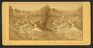
The Sandy River is a 73.3-mile-long (118.0 km) tributary of the Kennebec River in the U.S. state of Maine.

The Fort Bragg and Southeastern Railroad was formed by Atchison, Topeka and Santa Fe Railway as a consolidation of logging railways extending inland from Albion, California on the coast of Mendocino County. The railroad and its predecessors operated from August 1, 1885 to January 16, 1930. The line was merged into the regional Northwestern Pacific Railroad in 1907; but planned physical connection was never completed.

The Spruce Production Division was a unit of the United States Army established in 1917 to produce high-quality Sitka spruce timber and other wood products needed to make aircraft for the United States' efforts in World War I. The division was part of the Army Signal Corps's Aviation Section. Its headquarters were in Portland, Oregon, and its main operations center was at Vancouver Barracks in Vancouver, Washington. Workers in the division were members of the Loyal Legion of Loggers and Lumbermen, a union specifically established to support the army's wood production operations.
Saint Joseph is an unincorporated community in Yamhill County, Oregon, United States. It is located about two miles west of Lafayette near Oregon Route 99W. The area is sometimes known as "St. Joe".
Vaughn is an unincorporated community in Lane County, Oregon, United States. It is located about 4 miles (6.4 km) south of Noti in the foothills of the Central Oregon Coast Range near Noti Creek. Author Ralph Friedman described Vaughn as "a mill in the meadows".

The Oregon and Northwestern Railroad (O&NW) is a defunct railroad in eastern Oregon in the United States. It ran 50.2 miles (80.8 km) from Hines north to Seneca, which is on the edge of the Malheur National Forest, over a total of 19 trestles.

The Valley and Siletz Railroad (VS) is a 40.6-mile (65.3 km) defunct railroad located in Polk and Benton counties in the U.S. state of Oregon.
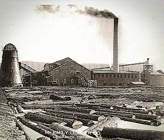
The Mount Emily Lumber Company operated in La Grande, Oregon from 1920 until 1956. After becoming a subsidiary of the Valsetz Lumber Company in 1955, the name was changed to Templeton Lumber Company. In 1960, the company was again sold and the name changed to Boise Cascade, La Grande.
Black Rock is an unincorporated community and former logging camp in Polk County, Oregon, United States. It is located about three miles west of Falls City, in the Central Oregon Coast Range on the Little Luckiamute River.

