Hapur is a city in, as well as the headquarters of, Hapur district, in Uttar Pradesh, India. Located about 60 kilometres (37 mi) east of New Delhi, the city is part of the Delhi National Capital Region (NCR). National Highway 9 passes through the city, connecting it to Delhi.

Meerut division is one of the 18 administrative geographical units of the northern Indian state of Uttar Pradesh. Meerut city is the administrative headquarters of the division. It consists of 6 districts:-

Meerut district, is one of the districts of Uttar Pradesh state of India, with the city of Meerut as the district headquarters. Meerut district is also a part of the Meerut division. The administrative head of district of Meerut is a District Magistrate while the administrative head of Meerut Division is Divisional Commissioner, an IAS officer.

Ghaziabad district is a largely suburban district of Uttar Pradesh state in northern India. It is also a core part of the National Capital Region. The city of Ghaziabad is the administrative headquarters of the district. This district is part of Meerut Division. It has become a major bedroom community for Delhi.
Babugarh Chavani is a town and a nagar panchayat in, near Hapur city in Hapur district, in the state of Uttar Pradesh, India. Babugarh Chavani is located almost 7 km away from Hapur towards Holy Pilgrimage Garhmukteshwar after crossing toll bridge near village "Tatarpur & Simroli". The name Chavani comes from EBS of the Indian Army. People of Babugarh are rich because their land is acquired by government for construction work. According to Land rules of Government of India government give them a huge amount of compensation for Land acquisition.

Garhmukteshwar is a city, just outside of Hapur city, and tehsil in Hapur district of the Indian state of Uttar Pradesh. According to Census 2011 information the sub-district code of Garhmukteshwar block is 00741. Total area of Garhmukteshwar is 272 km2 including 237.38 km2 rural area and 34.13 km2 urban area. Garhmukteshwar has a population of 46,077. There are 64,688 houses in the sub-district. There are about 137 villages in Garhmukteshwar block.Some of the prime places of the city are Nakka Kua, Ambedkar Gate, Meerut Adda and NH9Flyover [Choupla] also called Hapur Adda. This city is also the part of Delhi - NCR.
Pilkhuwa is a town and a municipal board in Hapur district in the Indian state of Uttar Pradesh. It is located 12 km from Hapur, the district headquarters. It is famous for its textile products and handloom industry.
Jalalabad (Jalālābād) is a town and a nagar panchayat in Shamli district in the Indian state of Uttar Pradesh. It is a historical town situated on Delhi Saharanpur road. Dating back to the Mughal period, situated close to the borders of Haryana and Uttarakhand states, and surrounded by a very fertile agricultural region namely famous for plentiful yields in grains and fruits, Jalalabad is internationally famous for its wood carving work cottage industry. It is a thriving market of local agricultural produce, including basmati rice and mangoes. A variety of agro-based industrial enterprises - such as textile, sugar, paper and cigarette factories - are located around it. It is 41 km from Saharanpur and 40 km from Muzaffarnagar.
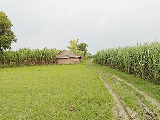
Raghunathpur is a village in Uttar Pradesh, India. It is part of the Hapur District. Raghunathpur is located 9.0 km from its main city Hapur. Raghunathpur is 30.2 km from Ghaziabad. The population mainly consists of Rajputs and Brahmans. Laxmangarhi is also the part of this village.
Hapur Lok Sabha Constituency was a parliamentary constituency in Uttar Pradesh till 2008. It was succeeded by Ghaziabad Lok Sabha constituency after the delimitation carried out in 2008.Now this is the part of Meerut Parliamentary Seat
Meerut Lok Sabha constituency is one of the 80 Lok Sabha (parliamentary) constituencies in the Indian state of Uttar Pradesh. This constituency covers parts of Meerut and Hapur districts.
Ghaziabad Lok Sabha constituency is one of the 80 Lok Sabha constituencies in Uttar Pradesh state in northern India. This constituency came into existence in 2008 as a part of the implementation of delimitation of parliamentary constituencies based on the recommendations of the Delimitation Commission of India constituted in 2002.

Hapur district is a recently formed district in the Indian state of Uttar Pradesh with a population of 1,338,211 at the 2011 Census. It arose as an area leading in the trade of grains and jaggery. This district on the Ganges river is 60 kilometres (37 mi) from New Delhi. Being located on the river could be a reason for its prosperity in trade. It is the smallest district of Uttar Pradesh.
Accheja is a village in the Hapur district of Uttar Pradesh, India. It is located 4 kilometres (2.5 mi) from the city of Hapur, and is home to seven temples, including Sai Mandir. It is well connected to Delhi, Ghaziabad and Meerut.

The Delhi–Moradabad line is a railway line connecting Delhi and Moradabad the latter in the Indian state of Uttar Pradesh. The Gajraula–Najibabad branch line is included in this line. The line is under the administrative jurisdiction of Northern Railway.
Dhaulana Assembly constituency is one of the 403 constituencies of the Uttar Pradesh Legislative Assembly, India. It is a part of the Ghaziabad district and one of the five assembly constituencies in the Ghaziabad Lok Sabha constituency. First election in this assembly constituency was held in 2012 after the "Delimitation of Parliamentary and Assembly Constituencies Order, 2008" was passed and the constituency was formed in 2008. The constituency is assigned identification number 58.
Hapur is one of the 403 constituencies of the Uttar Pradesh Legislative Assembly, India. It is a part of the Hapur district and one of the five assembly constituencies in the Meerut Lok Sabha constituency. First election in this assembly constituency was held in 1957 after the "DPACO (1956)" was passed in 1956. After the "Delimitation of Parliamentary and Assembly Constituencies Order, 2008" was passed in 2008, the constituency was assigned identification number 59. During the 02nd Vidhan Sabha (1957-1962), this constituency was represented by two MLAs simultaneously.
Bhudia is a village in the Hapur district of the Indian state of Uttar Pradesh. It is located 9 kilometres (5.6 mi) west of Gulaothi, 16 kilometres (9.9 mi) south of Hapur, 18 kilometres (11 mi) from Greater Noida and 56 kilometres (35 mi) from the Indian capital New Delhi.
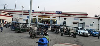
Hapur Junction railway station is the main railway station serving Hapur city in the Hapur district, Uttar Pradesh. Its code is HPU. The station consists of five platforms. Hapur is a major railway junction of northern India. Two lines – Delhi–Moradabad and Meerut–Bulandshahr–Khurja – pass through the city.
Dadayra is a village in Hapur tehsil in Hapur district in Uttar Pradesh.
