Related Research Articles
Pearse Island is an island in western British Columbia, Canada, in the Portland Inlet, an inlet of the Pacific Ocean. The island was first charted in 1793 by George Vancouver during his 1791-95 expedition. It was named by George Henry Richards, captain of HMS Plumper, circa 1860, in honour of William Alfred Rombulow Pearse of the Royal Navy, who had been commander of HMS Alert.

Princess Royal Island is the largest island on the North Coast of British Columbia, Canada. It is located amongst the isolated inlets and islands east of Hecate Strait on the British Columbia Coast. At 2,251 square kilometres (869 sq mi), it is the fourth largest island in British Columbia. It was named in 1788 by Captain Charles Duncan, after his ship Princess Royal.
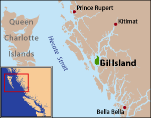
Gil Island is an island on the North Coast of British Columbia, Canada, located on the west side of Whale Channel in the entrance to Douglas Channel, one of the main coastal inlets, on the route of the Inside Passage between Pitt Island and Princess Royal Island. It is 26 km (16 mi) long, with a width ranging from 6 to 13 km, and an area of 231 km2. The only named summit on the mountainous island is Mount Gil, which faces the opening of Douglas Channel.

The Gwa'Sala-Nakwaxda'xw Nations are a union of two Kwakwaka'wakw peoples in a band government based on northern Vancouver Island in British Columbia, Canada, whose main reserve community is near the town of Port Hardy in the Queen Charlotte Strait region of the Central Coast region of British Columbia, Canada. The band government is a member of the Kwakiutl District Council and, for treaty negotiation purposes, the Winalagalis Treaty Group which includes three other members of the Kwakiutl District Council.
The Hartley Bay Indian Band is also known as the Gitga'at First Nation or the Hartley Bay First Nation. The members of the Gitga'at First nation are often referred to as Gitka'a'ata. The population of Gitk’a’ata peoples living in Hartley Bay ranges from approximately 130-200 people. There are also about 400-500 Gitk’a’ata peoples living in Prince Rupert, British Columbia, Canada, a neighboring territory. The Gitk’a’ata people have lived in Hartley Bay for hundreds of years, if not always. Some notable things regarding the Gitga'at First Nation are their economy, geography, government, sports involvement, COVID-19 regulations, and relations.
Actaeon Sound is a sound in the Queen Charlotte Strait region of the Central Coast of British Columbia, branching off northeasterly from the north side of Drury Inlet near its head on the mainland of British Columbia to the north of the town of Port McNeill, on the opposite side of Queen Charlotte Strait. On the south side of the sound is the Bond Peninsula at 50°56′50″N127°06′55″W, which is formed by a sidewater, Bond Lagoon at 50°56′34″N127°06′34″W, both presumably named in 1865 by Captain Pender, in association with other Admiralty and HMS Actaeon-related names.

Stephens Island is an island on the British Columbia Coast, Canaded in the Hecate Strait to the northwest of Porcher Island and to the southwest of the city of Prince Rupert. Its main geographic feature is Mount Stephens, at 432 m, on the island's southeast end at 54°07′39″N130°40′15″W. To its northwest is Congreve Hill, at 150 m, at 54°09′29″N130°42′31″W.

Smith Island is an island just north of the mouth of the Skeena River in the North Coast region of British Columbia, Canada. To the south of the island is Marcus Passage. To the north is Inverness Passage, separating Smith Island from the Tsimpsean Peninsula. Eleanor Passage, connects Osborn Point, the most eastern point on the island, with the mouth of the Skeena River. De Horsey Passage separates De Horsey Island from Smith Island on the latter's east side. Croasdaile Island is to the south of the southern tip of Smith Island.
Dashken Indian Reserve No. 22, officially Dashken 22, is an Indian reserve in the North Coast region of British Columbia, Canada, located on the east tip of Smith Island, which is immediately south of the Tsimpsean Peninsula and the City of Prince Rupert.
Kshaoom Indian Reserve No. 23, officially Kshaoom 23, 2.3 hectares in size, is an Indian reserve on the northwest tip of De Horsey Island, which is immediately south of the Tsimpsean Peninsula at the mouth of the Skeena River in the North Coast region of British Columbia, Canada. It and Dashken Indian Reserve No. 22, across De Horsey Passage on the east tip of Smith Island, are shared between the Metlakatla and Lax Kw'alaams band governments.
De Horsey Island is an island at the mouth of the Skeena River in the North Coast region of British Columbia, Canada, immediately south of the southern tip of the Tsimpsean Peninsula and immediately east of Smith Island. Separating it from that island is De Horsey Passage; and to its north, separating it from the Tsimpsean Peninsula, is Eleanor Passage. Kshaoom Indian Reserve No. 23 is on its northwest tip.
Harbledown Island is an island in the Central Coast region of British Columbia, Canada, located west of West Cracroft Island. It is at the west end of Johnstone Strait and lies at the eastern edge of the Queen Charlotte Strait region. Hanson Island is to its west, West Cracroft Island to the south and southeast, across Baronet Passage, and Turnour Island to the northwest, across Beware Passage.
Kalugwis, or Karlukwees or Qalogwis, is the principal community of the Tlowitsis Nation of the Kwakwaka'wakw peoples of the Johnstone Strait region of the South Coast of British Columbia, Canada. It is located on the south shore of Turnour Island facing Beware Passage and is within Karlukwees Indian Reserve No. 1, a.k.a. Karlukwees 1, 10.8 ha.

Turnour Island is an island in the Johnstone Strait region of the Central Coast of British Columbia, located between Gilford Island and West Cracroft Island. On the other side Canoe Passage on its northwest is Village Island, while to its south and southwest is Beware Passage, across from which is Harbledown Island. Gilford Island is to the north across Tribune Channel. Separating Turnour from West Cracroft is Clio Channel.

East Cracroft Island is an island in the Johnstone Strait region of the Central Coast region of British Columbia, Canada. It is the smaller of the two Cracroft Islands, and at low tide is really one island with its larger neighbour, West Cracroft Island. On the south side of the shallows that form an isthmus between them at low tide is Port Harvey, a short, wide inlet or bay. On its east shore is Keecekiltum Indian Reserve No. 2, which is under the governance of the Tlowitsis Nation of the Kwakwaka'wakw peoples. at 50°33′00″N126°16′00″W.
Village Island is an island in the Johnstone Strait region of the Central Coast region of British Columbia, Canada, located on the northwest side of Turnour Island.
Beware Passage is a strait or channel in the Central Coast region of British Columbia, Canada, between Harbledown (SE) and Turnour Islands. It was named in 1860 by Captain Pender.
Compton Island is an island in the Queen Charlotte Strait-Johnstone Strait region of the Central Coast of British Columbia, Canada, in Blackfish Sound to the east of Port McNeill All of it and three small adjacent islands comprise Compton Island Indian Reserve No. 6, a.k.a. Compton 6.
Drury inlet is an inlet in the Queen Charlotte Strait region of the Central Coast of British Columbia, Canada, extending west from Wells Passage to the northwest of North Broughton Island, northwest of the town of Port Hardy. Branching off to the northeast from the north side of the head of the inlet is Actaeon Sound.
Fin Island is an island in the North Coast region of British Columbia, Canada, to the northwest of Gil Island between Cridge and Lewis Passages.
References
- ↑ BC Names/GeoBC entry "De Horsey Passage"
- ↑ [British Columbia Coast Names 1592-1906, their origin and history, Capt John T. Walbran Ottawa, 1909], quote in BC Names entry
54°07′20″N130°10′03″W / 54.12222°N 130.16750°W
| | This article about a location on the North Coast of British Columbia, Canada is a stub. You can help Wikipedia by expanding it. |