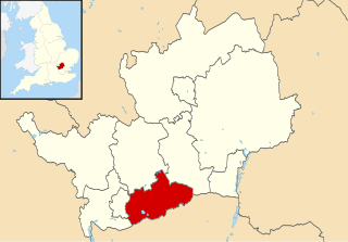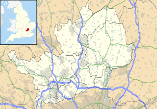
Hertsmere is a local government district and borough in Hertfordshire, England. Its council is based in Borehamwood. Other towns in the borough include Bushey, Elstree, Radlett and Potters Bar. The borough borders the three north London boroughs of Harrow, Barnet and Enfield, and is located mainly within the M25 Motorway.

Elstree Studios is a generic term which can refer to several current and defunct British film studios and television studios based in or around the towns of Borehamwood and Elstree in Hertfordshire. Studios have been located here since film production began in the area during 1914.

Bushey is a town in the Hertsmere borough of Hertfordshire in the East of England. It has a population of 24,000. Bushey Heath is a large neighbourhood south east of Bushey on the boundary with the London Borough of Harrow reaching elevations of 165 metres (541 ft) above sea level.

Elstree & Borehamwood railway station is a railway station in the town of Borehamwood, Hertfordshire, England. It primarily serves Borehamwood as well as the nearby village of Elstree, 1.3 miles (2.1 km) to the south-west. The station is situated on the Midland Main Line, 12 miles 35 chains (20.0 km) down the line from London St Pancras and is situated between Mill Hill Broadway to the south and Radlett to the north. Its three-letter station code is ELS.

Hertsmere is a constituency in Hertfordshire, England, represented in the House of Commons since 2015 by Oliver Dowden of the Conservative Party.

Elstree and Borehamwood is a civil parish in the Borough of Hertsmere in Hertfordshire, England. Located approximately 12 miles (19 km) northwest of central London and adjacent to the Greater London boundary, it is an urbanised parish with suburban residential development, some open land and light industry. Elstree and Borehamwood is a recent renaming of the ancient parish of Elstree, covering the settlements of Elstree and Borehamwood. Formed in 1894 as the Elstree Parish Council, the local council is Elstree and Borehamwood Town Council. One of the most populous civil parishes in England, at the 2011 census it had a population of 37,065.

Pegsdon Hills and Hoo Bit is a 79 hectare nature reserve in Pegsdon in Bedfordshire. It is managed by the Wildlife Trust for Bedfordshire, Cambridgeshire and Northamptonshire. The site is on the border between Bedfordshire and Hertfordshire, and it covers Pegsdon Hills and part of the adjacent Deacon Hill in Bedfordshire, and Hoo Bit in Hertfordshire. It is in the Chilterns Area of Outstanding Natural Beauty, and part of the site is designated by Natural England as the Deacon Hill SSSI.

Aldenham House is a former country house in Elstree, just south-east of Aldenham village and west of Borehamwood, Hertfordshire, which was the seat of the Gibbs family, who were the Barons Aldenham. The site today accommodates the Hilfield Reservoir, the Lister Institute, the Haberdashers' Aske's Boys' School and Haberdashers' Aske's Girls' School.
This page provides brief details of primary schools in the borough of Hertsmere in Hertfordshire, England, United Kingdom.

BBC Elstree Centre, sometimes referred to as BBC Elstree Studios, is a television production facility located on Eldon Avenue in Borehamwood, Hertfordshire.

The 2002 Hertsmere Borough Council election took place on 2 May 2002 to elect members of Hertsmere Borough Council in Hertfordshire, England. One third of the council was up for election and the Conservative party stayed in overall control of the council.

The 2003 Hertsmere Borough Council election took place on 1 May 2003 to elect members of Hertsmere Borough Council in Hertfordshire, England. One third of the council was up for election and the Conservative party stayed in overall control of the council.

The 2004 Hertsmere Borough Council election took place on 10 June 2004 to elect members of Hertsmere Borough Council in Hertfordshire, England. One third of the council was up for election and the Conservative party stayed in overall control of the council.

The 2006 Hertsmere Borough Council election took place on 4 May 2006 to elect members of Hertsmere Borough Council in Hertfordshire, England. One third of the council was up for election and the Conservative party stayed in overall control of the council.

Woodcock Hill Village Green or Woodcock Hill Open Space is an area of grass and woodland in Borehamwood in Hertfordshire in England. It was designated a Village Green in 2008 to prevent development of the site.

The Elstree Project is an oral history project which began in 2010. The project is conducted in partnership by the University of Hertfordshire and Elstree Screen Heritage. The project is endorsed by the BECTU History Project and Elstree Studios.

The Watling Chase Timberland Trail is a 10.5 mile footpath in the Watling Chase Community Forest in Hertfordshire. It starts at Elstree & Borehamwood railway station, where it links with the London Loop, and goes mainly through farmland and parks. It passes through Shenley, London Colney and Colney Heath, finishing in Smallford near St Albans, where it links with the Alban Way.

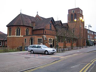
All Saints church is a Church of England church in Shenley Road, Borehamwood. It is in the parish of Elstree and Borehamwood. The church is built in the Jacobean style and dates from 1909.


