
Montana is a state in the Mountain region of the Western United States. It is bordered by Idaho to the west, North Dakota and South Dakota to the east, Wyoming to the south, and the Canadian provinces of Alberta, British Columbia, and Saskatchewan to the north. It is the fourth-largest state by area, the eighth-least populous state, and the third-least densely populated state. Its capital is Helena, while the most populous city is Billings. The western half of the state contains numerous mountain ranges, while the eastern half is characterized by western prairie terrain and badlands, with smaller mountain ranges found throughout the state.

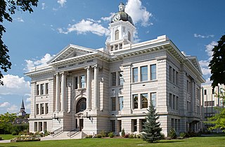
Helena is the capital city of the U.S. state of Montana and the seat of Lewis and Clark County.
Missoula County is located in the State of Montana. As of the 2020 census, the population was 117,922, making it Montana's third-most populous county. Its county seat and largest city is Missoula. The county was founded in 1860.

Gallatin County is located in the U.S. state of Montana. With its county seat in Bozeman, it is the second-most populous county in Montana, with a population of 118,960 in the 2020 Census.

Custer County is a county located in the U.S. state of Montana. As of the 2020 census, the population was 11,867. Its county seat is Miles City. The county was established on June 2, 1865, as one of the nine original counties of the Territory of Montana named Big Horn County, and was renamed on February 16, 1877, in honor of Lieutenant Colonel George Armstrong Custer.

Bigfork is a census-designated place (CDP) in Flathead County, Montana, United States. It is within Montana's Rocky Mountains. The population was 5,118 at the 2020 census, up from 4,270 in 2010.
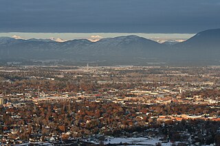
Kalispell is a city in Montana and the county seat of Flathead County, Montana, United States. The 2020 census put Kalispell's population at 24,558. In Montana's northwest region, it is the largest city and the commercial center of the Kalispell Micropolitan Statistical Area. The name Kalispell is a Salish word meaning "flat land above the lake".

The Waterton-Glacier International Peace Park is the union of Waterton Lakes National Park in Canada and Glacier National Park in the United States. Both parks are declared Biosphere Reserves by UNESCO and their union as a World Heritage Site.

Pompton Plains is a census-designated place (CDP) and unincorporated community constituting the majority of Pequannock Township, Morris County, in the U.S. state of New Jersey. As of the 2020 United States census, the CDP's population was 11,144. The community was first listed as a CDP in advance of the 2020 census.

Benton Lake National Wildlife Refuge is a 12,459-acre (5,042 ha) National Wildlife Refuge (NWR) in the central part of the U.S. state of Montana.
Medicine Lake National Wildlife Refuge is a 31,533-acre (12,761 ha) National Wildlife Refuge located in the northeastern region of the U.S. state of Montana. The refuge is part of the Medicine Lake National Wildlife Refuge Complex which also includes the Northeast Montana Wetland Management District (WMD) and Lamesteer National Wildlife Refuge. Medicine Lake is from the Assiniboine description of the lake, "Bda wauka". The refuge was established in 1935 to protect habitat for various wildlife and especially migratory birds. The refuge is managed by the U.S. Fish and Wildlife Service, an agency of the U.S. Department of the Interior. In 1980, the Medicine Lake Site was designated as a National Natural Landmark by the National Park Service.
The following outline is provided as an overview of and topical guide to the U.S. state of Montana:

Fairy Lake is a lake in Gallatin County, Montana at the base of Sacagawea Peak, a part of the Bridger mountains in south central Montana. It is located within the northwestern section of the Gallatin National Forest and sits at an elevation of 7,557 ft (2,303 m).
The Regional designations of Montana vary widely within the U.S state of Montana. The state is a large geographical area that is split by the Continental Divide, resulting in watersheds draining into the Pacific Ocean, Gulf of Mexico and Hudson's Bay. The state is approximately 545 miles (877 km) east to west along the Canada–United States border and 320 miles (510 km) north to south. The fourth largest state in land area, it has been divided up in official and unofficial ways into a variety of regions. Additionally, Montana is part of a number of larger federal government administrative regions.

Whitefish Lake State Park is a 10-acre (4.0 ha) public recreation area on Whitefish Lake off of U.S. Highway 93, two miles northwest of Whitefish, Montana. It offers boating, swimming, tent and RV camping, and fishing. Sites for hike-in and bike-in camping were added in 2016.
Dean is an unincorporated community located in Stillwater County, Montana, United States.
Swan Lake is a census-designated place and unincorporated community in Lake County, Montana, United States. Its population was 113 as of the 2010 census.
Lake Mary Ronan is a census-designated place (CDP) in Lake County, Montana, United States. The population was 65 at the 2010 census. The CDP is in northwestern Lake County, along the northern and eastern shores of Lake Mary Ronan, and includes the populated places of Lake Mary Ronan, Melton, and Sipes, as well as Lake Mary Ronan State Park. It is 8 miles (13 km) northwest of U.S. Route 93 at Dayton, and 30 miles (48 km) northwest of Polson, the Lake county seat.
West Kootenai is a census-designated place (CDP) in Lincoln County, Montana, United States. The population was 365 at the 2010 census.


