Related Research Articles

Pagosa Springs is a municipality that is the county seat of, and the only incorporated municipality in, Archuleta County, Colorado, United States. The population was 1,727 at the 2010 census. Approximately 65 percent of the land in Archuleta County is either San Juan National Forest, Weminuche and South San Juan Wilderness areas, or Southern Ute Indian land.

The South Santiam River is a tributary of the Santiam River, about 69 miles (111 km) long, in western Oregon in the United States. It drains an area of the Cascade Range into the Willamette Valley east of Corvallis.
The Skatin First Nations, aka the Skatin Nations, are a band government of the In-SHUCK-ch Nation, a small group of the larger St'at'imc people who are also referred to as Lower Stl'atl'imx. The Town of Skatin - the St'at'imcets version of the Chinook Jargon Skookumchuck- is located 4 km south of T'sek Hot Spring- alt. spelling T'sek Hot Spring - commonly & formerly named both St. Agnes' Well & Skookumchuck Hot Springs The community is 28 km south of the outlet of Lillooet Lake on the east side of the Lillooet River. It is approximately 75 km south of the town of Pemberton and the large reserve of the Lil'wat branch of the St'at'imc at Mount Currie. Other bands nearby are Samahquam at Baptiste Smith IR on the west side of the Lillooet River at 30 km. and Xa'xtsa First Nations; the latter is located at Port Douglas, near the mouth of the Lillooet River where it enters the head of Harrison Lake. The N'Quatqua First Nation on Anderson Lake, between Mount Currie and Lillooet, was at one time involved in joint treaty negotiations with the In-SHUCK-ch but its members have voted to withdraw, though a tribal council including the In-SHUCK-ch bands and N'Quatqua remains, the Lower Stl'atl'imx Tribal Council.

Liard River Hot Springs Provincial Park is a provincial park in British Columbia, Canada. It is home to the largest natural hot springs in Canada. It is a natural river of hot water rather than a spring fed man made pool The park is part of the larger Muskwa-Kechika Management Area. The community of Liard River, British Columbia is located nearby.
Umpqua Hot Springs is a geothermal pool located along the North Umpqua River in the U.S. state of Oregon at 2,640 feet (800 m) elevation. Two oval pools are available for soaking, the larger having a solid rock bottom and the smaller a bottom of coarse sand. The larger is five by eight feet and 110 °F (43 °C), and is covered by a wooden enclosure. The upper pool is smaller but slightly warmer, measuring four by five feet and 112 °F (44 °C). Both pools are approximately two and a half feet deep. Umpqua is clothing optional.

White Deer Creek is a tributary of the West Branch Susquehanna River in Centre County and Union County, in Pennsylvania, in the United States. It is approximately 28 miles (45 km) long and flows through Miles Township in Centre County and Hartley Township, Lewis Township, West Buffalo Township, and White Deer Township in Union County. The watershed of the creek has an area of 45.1 square miles (117 km2). Parts of the creek are designated as impaired. The creek's discharge near White Deer can be as low as 3 cubic feet per second (0.085 m3/s) or as high as 169 cubic feet per second (4.8 m3/s).

Belknap Springs is an unincorporated community and private hot springs resort in Lane County, Oregon, United States, near the McKenzie River. The springs were located and initially developed by R. S. Belknap in 1869. A post office named "Salt Springs" was established in the location in 1874, and the name changed to "Belknap Springs" in 1875. The post office closed in 1877 and reopened in 1891, operating intermittently until 1953. Today the location uses a McKenzie Bridge mailing address.

Paradise Valley is a major river valley of the Yellowstone River in southwestern Montana just north of Yellowstone National Park in Park County, Montana. The valley is flanked by the Absaroka Range on the east and the Gallatin Range on the west.

The Oregon Coast Range, often called simply the Coast Range and sometimes the Pacific Coast Range, is a mountain range, in the Pacific Coast Ranges physiographic region, in the U.S. state of Oregon along the Pacific Ocean. This north-south running range extends over 200 miles (320 km) from the Columbia River in the north on the border of Oregon and Washington, south to the middle fork of the Coquille River. It is 30 to 60 miles wide and averages around 1,500 feet (460 m) in elevation above sea level. The coast range has three main sections, a Northern, Central, and Southern.

Butte Creek is a stream in the U.S. state of Oregon, a tributary of the Pudding River. It is approximately 33 miles (53 km) long and, for all of its course, defines part of the northeastern boundary of Marion County and the southern boundary of Clackamas County.

The Middle Fork of the Salmon River is a 104-mile-long (167 km) river in central Idaho in the northwestern United States. The Middle Fork is a tributary to the Salmon River, and it lies in the center of the 2.5-million-acre Frank Church-River of No Return Wilderness Area. Designated by the United States Congress as a federally protected wilderness in 1980, it is part of the largest roadless area left in the lower 48 states.

Meager Creek is a creek in the southern Pacific Ranges of the Coast Mountains in British Columbia, Canada. It flows northeast into the Lillooet River approximately 95 km (59 mi) northwest of the village of Pemberton and is adjacent to the Upper Lillooet Provincial Park.
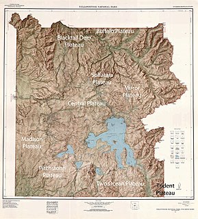
There are nine named plateaus in Yellowstone National Park. These plateaus are part of the much larger Yellowstone Plateau and dominate areas in the park south and west of the Gallatin and Absaroka mountain ranges. Four of the plateaus are from rhyolite lava flows that occurred between 110,000 and 70,000 years ago.

The Tamolitch Falls, now a seasonal waterfall ,once had a constant flow on the McKenzie River in Linn County, Oregon. The site is located in the Willamette National Forest. In the 1960s, water was diverted for hydroelectric use from the stream above the falls; that section of the stream, as well as the falls, ceased to flow except during periods of heavy runoff or when water was diverted from the dams upstream. When this is not the case, the stream goes underground and now emerges below the falls. At the base of the former falls is the Tamolitch Blue Pool, a small body of water known for its blue color. Visitors to Blue Pool should note that water temperatures are extremely cold. Swimming is not encouraged or recommended. The area is accessible via Oregon Route 126.

Crabtree Hot Springs is a geological phenomenon in Lake County, California about 25 miles (40 km) north of Upper Lake. It is located on private property and closed to the public. It lies at an elevation of 2,257 feet. There is a cluster of four natural hot springs at this location, in an isolated narrow winding steep walled canyon on the north bank of the Rice Fork of the Eel River, about one fourth mile downriver from its junction with Salt Creek. Three of the hot springs are aligned in one area at a large swimming hole, while the fourth hot spring is about 60 feet back upriver. The temperature of the hottest spring is 106 °F (41 °C), with a flow rate of about 10 US gallons (38 L) per minute.
The Rice Fork is a 22.7-mile-long (36.5 km) tributary of the Eel River in Lake County, California. The Rice Fork begins on the upper northwest side of Goat Mountain, on the Colusa-Lake County line, at an elevation of over 6,000 feet (1,800 m). It quickly descends the steep western slope of the mountain, then bends northward, and flows northwesterly down a narrow winding steep walled canyon for about 18 miles (29 km), crossing two forest roads and adding many tributaries, ending its journey at the southern tip of Lake Pillsbury, at a varied elevation around 1,800 feet (550 m), depending on the lake level. Before the construction of Scott Dam in the 1920s, which formed Lake Pillsbury, the Rice Fork ran directly into the Eel River. It is one of Lake County's longest streams.

The South Fork McKenzie River is a tributary, about 31 miles (50 km) long, of the McKenzie River in the U.S. state of Oregon. It begins at about 4,500 feet (1,400 m) above sea level near Mink Lake in the Three Sisters Wilderness of the Cascade Range. Flowing northwest within Lane County, it meets the McKenzie River about 60 miles (97 km) from the larger river's confluence with the Willamette River.

The Pennsylvania State Game Lands Number 30 are Pennsylvania State Game Lands in McKean County in Pennsylvania in the United States providing hunting, bird watching, and other activities.
References
- ↑ "Deer Creek (Bigelow) Hot Springs" . Retrieved 2008-10-19.
- 1 2 "Bigelow (Deer Creek) Hot Springs" . Retrieved 2008-10-19.
Coordinates: 44°14′28″N122°03′32″W / 44.24113°N 122.05881°W
| This Lane County, Oregon state location article is a stub. You can help Wikipedia by expanding it. |