
Deer Island
Location of Deer Island in Newfoundland and Labrador
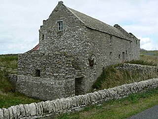
Deer Island is an abandoned community in Newfoundland and Labrador.
Deer Island is an abandoned community in Newfoundland and Labrador.
Scalpay is an inhabited island in the Inner Hebrides of Scotland which has a population of 4.

Deer Lake is a town in the western part of the island of Newfoundland in the province of Newfoundland and Labrador, Canada.

Deer Island is an island off the coast of Biloxi, Mississippi that was once part of the mainland and is not a barrier island. It is the closest island to the Mississippi Gulf Coast, and consists of approximately 400 acres (1.6 km2). In 2011, TITANTubes, sometimes referred to as geotubes, were utilized as low profile dune cores to protect the island.

The River Ugie or Ugie Water is a river in North East Scotland; it flows into the North Sea on the east coast at Peterhead, north of Cruden Bay. There is considerable evidence of prehistoric settlement within the Ugie drainage basin, especially in the South Ugie Water catchment basin. For example, the Catto Long Barrow is found somewhat to the south of the Ugie Water mainstem.

Gobler is an unincorporated community on the border between Dunklin and Pemiscot counties in the U.S. state of Missouri. It is located nineteen miles west-southwest of Caruthersville and seven miles southeast of Kennett. The community is on Missouri Route NN and the old St. Louis Southwestern Railway line which is now Dunklin County Road 710.
Fortune Bay is a fairly large natural bay located in the Gulf of St. Lawrence on the south coast of Newfoundland, Canada. The Bay is bounded by Point Crewe on the Burin Peninsula and Pass Island at the entrance to Hermitage Bay to the northwest for a distance of 56 kilometers. The bay extends in a northeast direction for 105 kilometers ending at Terrenceville.

Reidville is a village located north east of Deer Lake. A post office was established in 1967 and the first Postmisstress was Dorothy Barrett.

The Philippine deer, also known as the Philippine sambar or Philippine brown deer, is a vulnerable deer species endemic to the Philippines. It was first described from introduced populations in the Mariana Islands, hence the specific name.

The Ness Islands are situated on the River Ness, opposite the Bught Park, in the city of Inverness, Scotland. The first bridges to the islands were built in 1828; prior to their construction the only access to the islands was by boat. The original bridges were washed away in the flood of 1849 and were replaced in 1853-1854 by two suspension bridges designed by William Dredge.
Glover Island is a large (178 km2) lake island in the interior of the Island of Newfoundland in the province of Newfoundland and Labrador, Canada. It is the 18th largest lake island in the world by area. The island is located in Grand Lake, a natural lake whose waters were raised for the Deer Lake Power Development. Historic maps show that Glover Island pre-dates this.
Little Deer Isle is an island in Penobscot Bay, lying just north of the town of Deer Isle, of which it is a part. The island is served by Maine State Route 15 via the Deer Isle Bridge. The north end of the island is called Eggemoggin and there is a small island with a lighthouse on it at the tip called Pumpkin Island. Little Deer is about four miles (6.4 km) long and connects to Deer Isle by way of a causeway. There are only about 300 year-round residents of Little Deer, but many more summer residents. There is abundant wildlife on the island including deer, fox, squirrels, wild turkeys, ospreys, and bald eagles.
St Andrews is a parish on Mainland, Orkney in Scotland. It is located east of the town of Kirkwall and the parish of St Ola and lies north of Holm and west of Deerness. The settlements of Tankerness, Toab and Foubister are in the parish, as is Kirkwall Airport.
Raspberry Island is one of the Apostle Islands in northern Wisconsin, in Lake Superior, and is part of the Apostle Islands National Lakeshore. The island is part of the Town of Russell, in Bayfield County. The Raspberry Island Light is located on the island.
Deer Island is an island located at the mouth of Cold Bay on the south side of the Alaska Peninsula in the state of Alaska in the United States. It lies about 5 miles (8.0 km) directly south of the mainland city of King Cove, across Deer Passage. The Sanak Islands lie to its south, and the Pavlof Islands to its northeast. The island has a land area of 151.7 km2 and is uninhabited.
West Island is an island in Fairhaven, Massachusetts, United States, on Buzzards Bay. Approximately two-thirds of the island is forest. Water and sewage restrictions have limited its growth. Fairhaven is located in southeastern Bristol County, near the city of New Bedford.
The temperate rainforests of Admiralty Island's Kootznoowoo Wilderness are unique among the 5,700,000 acres (2,300,000 ha) of federally protected Wilderness in Southeast Alaska.
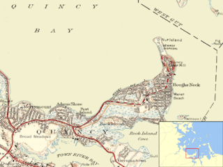
Nut Island is a former island in Boston Harbor, part of the Boston Harbor Islands National Recreation Area. The island has been connected through a short causeway to the end of Houghs Neck, becoming part of the mainland of Quincy, Massachusetts.
The Shag Islands are a small group of islands in the southern part of Coppett Harbour, off the south coast of Newfoundland, Canada. They lie to the east of Bonalds Island. The southernmost island, Shag Island, is described as "a conspicuous white rock, 12.8m high".
Broad Sound is a bay on the Massachusetts coast north of Boston. It lies on the west of Massachusetts Bay, between Nahant and Deer Island; Lynn harbor is at its north end. The main channel of Boston Harbor empties into the sound.
Casco Bay Island, formerly Casco Island, is a private island located in Passamaquoddy Bay, between Campobello Island and Deer Island, in New Brunswick, Canada. The island is approximately 41 acres in size, at the mean high tide line. Found at 44°57'20" North and 66°55'55" West.
Coordinates: 47°37′23″N57°21′59″W / 47.6230742°N 57.3663883°W
| | This Newfoundland and Labrador location article is a stub. You can help Wikipedia by expanding it. |
| | This Canadian ghost town-related article is a stub. You can help Wikipedia by expanding it. |