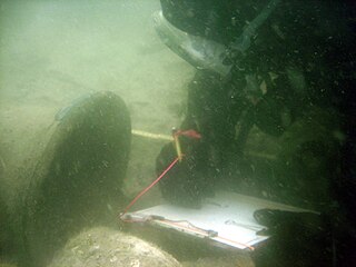
Maritime archaeology is a discipline within archaeology as a whole that specifically studies human interaction with the sea, lakes and rivers through the study of associated physical remains, be they vessels, shore-side facilities, port-related structures, cargoes, human remains and submerged landscapes. A specialty within maritime archaeology is nautical archaeology, which studies ship construction and use.
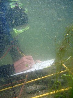
Underwater archaeology is archaeology practiced underwater. As with all other branches of archaeology, it evolved from its roots in pre-history and in the classical era to include sites from the historical and industrial eras. Its acceptance has been a relatively late development due to the difficulties of accessing and working underwater sites, and because the application of archaeology to underwater sites initially emerged from the skills and tools developed by shipwreck salvagers. As a result, underwater archaeology initially struggled to establish itself as bona fide archaeological research. The situation changed when universities began teaching the subject and when a theoretical and practical base for the sub-discipline was firmly established. Underwater archaeology now has a number of branches including, after it became broadly accepted in the late 1980s, maritime archaeology: the scientifically based study of past human life, behaviours and cultures and their activities in, on, around and (lately) under the sea, estuaries and rivers. This is most often effected using the physical remains found in, around or under salt or fresh water or buried beneath water-logged sediment. In recent years, the study of submerged WWII sites and of submerged aircraft in the form of underwater aviation archaeology have also emerged as bona fide activity.
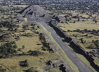
Teotihuacan (Spanish pronunciation: [teotiwa'kan], is an ancient Mesoamerican city located in a sub-valley of the Valley of Mexico, which is located in the State of Mexico, 40 kilometres northeast of modern-day Mexico City. Teotihuacan is known today as the site of many of the most architecturally significant Mesoamerican pyramids built in the pre-Columbian Americas. At its zenith, perhaps in the first half of the first millennium, Teotihuacan was the largest city in the pre-Columbian Americas, with a population estimated at 125,000 or more, making it at least the sixth-largest city in the world during its epoch. After the collapse of Teotihuacan, central Mexico was dominated by the Toltecs of Tula until about 1150 CE.

Lubaantun is a pre-Columbian ruined city of the Maya civilization in southern Belize, Central America. Lubaantun is in Belize's Toledo District, about 42 kilometres (26 mi) northwest of Punta Gorda, and approximately 3.2 kilometres (2 mi) from the village of San Pedro Columbia, at an elevation of 61 metres (200 ft) feet above mean sea level. One of the most distinguishing features of Lubaantun is the large collection of miniature ceramic objects found on site; these detailed constructs are thought to have been charmstones or ritual-accompanying accoutrements.

Tulum is the site of a pre-Columbian Mayan walled city which served as a major port for Coba, in the Mexican state of Quintana Roo. The ruins are situated on 12-meter (39 ft) tall cliffs along the east coast of the Yucatán Peninsula on the Caribbean Sea in the state of Quintana Roo, Mexico. Tulum was one of the last cities built and inhabited by the Maya; it was at its height between the 13th and 15th centuries and managed to survive about 70 years after the Spanish began occupying Mexico. Old World diseases brought by the Spanish settlers appear to have resulted in very high fatalities, disrupting the society, and eventually causing the city to be abandoned. One of the best-preserved coastal Maya sites, Tulum is today a popular site for tourists.

Lamanai is a Mesoamerican archaeological site, and was once a major city of the Maya civilization, located in the north of Belize, in Orange Walk District. The site's name is pre-Columbian, recorded by early Spanish missionaries, and documented over a millennium earlier in Maya inscriptions as Lam'an'ain. Lamanai is renowned for its exceptionally long occupation spanning three millennia, beginning in the Early Preclassic Maya period and continuing through the Spanish and British Colonial periods, into the 20th century. Unlike most Classic-period sites in the southern Maya lowlands, Lamanai was not abandoned at the end of the 10th century AD.
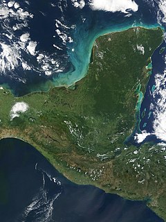
The Yucatán Peninsula, in southeastern Mexico, separates the Caribbean Sea from the Gulf of Mexico, with the northern coastline on the Yucatán Channel. The peninsula lies east of the Isthmus of Tehuantepec, a northeastern geographic partition separating the region of Central America from the rest of North America. It is approximately 181,000 km2 (70,000 sq mi) in area, and is almost entirely composed of limestone.
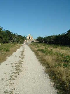
A sacbe, plural sacbeob, or "white way", is a raised paved road built by the Maya civilization of pre-Columbian Mesoamerica. Most connect temples, plazas, and groups of structures within ceremonial centers or cities, but some longer roads between cities are also known. The term "sacbe" is Yucatec Maya for "white road"; white perhaps because there is evidence that they were originally coated with limestone stucco or plaster, which was over a stone and rubble fill.

The archaeology of shipwrecks is the field of Archaeology specialized most commonly in the study and exploration of shipwrecks. Its techniques combine those of archaeology with those of diving to become Underwater archaeology. However, shipwrecks are discovered on what have become terrestrial sites.

Ancient Maya cuisine was varied and extensive. Many different types of resources were consumed, including maritime, flora, and faunal material, and food was obtained or produced through strategies such as hunting, foraging, and large-scale agricultural production. Plant domestication concentrated upon several core foods, the most important of which was maize.

The Pre-Columbian Belize history is the period from initial indigenous presence, across millennia, to the first contacts with Europeans - the Pre-Columbian or before Columbus period - that occurred on the region of the Yucatán Peninsula that is present day Belize.

Blue Creek is a riverine system and major archaeological site located in North-Western Belize, Central America. It is situated geographically on the Belize–Mexico border and then continues south across the Guatemala–Mexico border. The river is commonly known as the Rio Azul or ‘Azul River’ in Spanish, which translates to ‘blue river’ or ‘blue creek’ in English.

Howieson's Poort Shelter is a small rock shelter in South Africa containing the archaeological site from which the Howiesons Poort period in the Middle Stone Age gets its name. This period lasted around 5,000 years, between roughly 65,800 BP and 59,500 BP. This period is important as it, together with the Stillbay period 7,000 years earlier, provides the first evidence of human symbolism and technological skills that were later to appear in the Upper Paleolithic.
Pusilhá is an archaeological site in Belize. The location of this Late Classic Mayan urban complex, along the east and west flow of trade, made the city a major transfer point for economic activities in the whole region. In addition, the city gave archaeologists a historical view of a secondary Mayan site. Large and extended excavation efforts have changed the overall picture of Maya social and political relationships between larger and smaller cities and challenged the prevailing view of conquest and absorption of smaller cities into the larger cities in the region. The research conducted at Pusilhá began in 1927 and continues to this day.

Nelson Bay Cave also known as Wagenaar's Cave is a Stone Age archaeological site located on the Robberg Peninsula and facing Nelson's Bay near Plettenberg Bay in South Africa, and showing evidence of human occupation as far back as 125,000 years ago.

The extensive trade networks of the Ancient Maya contributed largely to the success of their civilization spanning three millennia. The Maya royals control and wide distribution of foreign and domestic commodities for both population sustenance and social affluence are hallmarks of the Maya visible throughout much of the iconography found in the archaeological record. In particular, moderately long distance trade of foreign commodities from the Caribbean and Gulf Coasts provided the larger inland Maya cities with the resources they needed to sustain settled population levels in the several thousands. Though the ruling class essentially controlled the trade economy, a middle merchant class supervised import and export from cities and trade ports. Not much is known of the Maya merchant class; however, merchants of royal lineage are sometimes represented in the iconography. Notably, a canoe paddle often accompanies the royal merchant depictions, signifying their association with marine resources. Water lilies are also a recognizable feature of Maya iconography, appearing on ceramics and murals in landlocked cities like Palenque where the lilies cannot grow, further indicating the important political symbolism of water connections. The dugout style canoes of the Maya and other small watercraft are also represented in various codices, sometimes ferrying royal figures or deities. The rich tradition of maritime trade has continued into the modern era, exemplified by the resource exploitation of the coastal lagoons and cay locations along the Caribbean coast of Mexico, Belize, Guatemala, and Honduras. Eventually, the intensification of maritime trade reliance aided in the collapse of interior Maya power regimes, shifting political influence to coastal polities such as Uxmal and Chichen Itza in the Terminal Classic. A seaborne trade economy would continue to dominate the Maya civilization until the period of European Contact.
Anabel Ford is an American archaeologist specializing in the study of Mesoamerica, with a focus on the lowland Maya of Belize and Guatemala. She is recognized for her discovery of the ancient Maya city El Pilar. Ford is currently affiliated with the Institute of Social Behavioral and Economic Research (ISBER) and is the director of the MesoAmerican Research Center (MARC) at the University of California, Santa Barbara.

The Belize leaf-toed gecko is a species of gecko native to Belize. It is a small, pale, large headed gecko only found on small islands off Belize's coast and was first described by James R. Dixon in 1960. This species is currently classified as "vulnerable" by the IUCN Red List.
Arturo Gómez-Pompa is a tropical biologist, a scientific advisor for the Tropical Research Center of the Universidad Veracruzana (CITRO), and a professor emeritus of botany at the University of California, Riverside. He made various contributions to the field of tropical ecology through the creation of databases used in botanical research, and he contributed to the research on the domestication of tropical trees.
Elizabeth Graham is a Professor of Mesoamerican Archaeology at UCL.


