Denge Marsh

Last updated

Denge Marsh Sewer Dengemarsh Sewer - geograph.org.uk - 448984.jpg
Denge Marsh Sewer

Denge Marsh is a part of Romney Marsh in Kent. Its north-west boundary is the town of Lydd; to the south-east is Denge Beach and Dungeness. [1]

Romney Marsh wetland area in Kent and East Sussex, England

Romney Marsh is a sparsely populated wetland area in the counties of Kent and East Sussex in the south-east of England. It covers about 100 square miles (260 km2).

Kent County of England

Kent is a county in South East England and one of the home counties. It borders Greater London to the north west, Surrey to the west and East Sussex to the south west. The county also shares borders with Essex along the estuary of the River Thames, and with the French department of Pas-de-Calais through the Channel Tunnel. The county town is Maidstone.

Lydd town in Kent, England

Lydd is a town and electoral ward in Kent, England, lying on the Romney Marsh. It is one of the larger settlements on the marsh, and the most southerly town in Kent. Lydd reached the height of its prosperity during the 13th century, when it was a corporate member of the Cinque Ports, a "limb" of Romney. Actually located on Denge Marsh, Lydd was one of the first sandy islands to form as the bay evolved into what is now called the Romney Marsh. The name Hlyda, which derives from the Latin word for "shore", was found in a Saxon charter dating from the 8th century.

Contents

History

In Roman times, the area which is now Romney Marsh was under water; Lympne and Appledore, now on the northern edge of Romney Marsh, were coastal ports. There were islands in the area, including Lydd. Denge Marsh, south-east of Lydd, was one of the earliest parts in the area to be reclaimed; this is recorded in a charter of A.D. 744. Reclamation of the adjacent area, the present-day Walland Marsh which is to the north-west of Lydd, continued through the Middle Ages. Drainage dykes, known locally as sewers, were built. [2] [3]

Lympne village in the United Kingdom

Lympne, formerly also Lymne, is a village on the former shallow-gradient sea cliffs above the expansive agricultural plain of Romney Marsh in Kent. The settlement forms an L shape stretching from Port Lympne Zoo via Lympne Castle facing Lympne Industrial Park then via the main settlement to Newingreen in the north, centred 11 km (7 mi) west of Folkestone, 2.3 mi (3.7 km) west of Hythe and 13 km (8.1 mi) ESE of Ashford.

Appledore, Kent village and civil parish in the Ashford District of Kent, England

Appledore is a village and civil parish in the Ashford District of Kent, England. The village centre is on the northern edge of the Romney Marsh, 12 miles (19 km) south-west of Ashford town. The northerly part of this village is Appledore Heath.

Walland Marsh

Walland Marsh is a part of Romney Marsh, mostly in Kent with part in East Sussex. The name means wall-land: its north-eastern border, separating it from the rest of Romney Marsh, is the Rhee Wall.

Sound mirrors

At the north-eastern edge of Denge Marsh, near Greatstone-on-Sea, are the sound mirrors at Denge: they are large concrete structures, built as an experiment between 1928 and 1930, by which sound could be focussed onto microphones, so giving an early warning of the approach of enemy aircraft. They soon became obsolete with the invention of radar. [4]

Greatstone-on-Sea village in United Kingdom

Greatstone is a beach-side town, the third town up from the "point" of the Romney Marsh area of Kent. It is situated near the largest town there, New Romney in Kent, England. Permission was given in the 1920s for a company to construct large numbers of homes and facilities; only a small number were built. There was widespread development in the 1960s and 1970s, however, leading to a sizable community. The church of St Peter's, built in the 1960s, is a daughter church of All Saints, Lydd, in which parish half of Greatstone is situated. It is in the civil parish of Lydd. There is a small group of shops at one end of the town, and the other end simply melds into Lydd-on-Sea. The local school is the Greatstone Primary School, from which most students either go on to The Marsh Academy, the Folkestone School for Girls or the Harvey Grammar School.

Acoustic mirror

An acoustic mirror is a passive device used to reflect and focus (concentrate) sound waves. Parabolic acoustic mirrors are widely used in parabolic microphones to pick up sound from great distances, employed in surveillance and reporting of outdoor sporting events. Pairs of large parabolic acoustic mirrors which function as "whisper galleries" are displayed in science museums to demonstrate sound focusing.

RAF Denge

Denge is a former Royal Air Force site near Dungeness, in Kent, England. It is best known for the early experimental acoustic mirrors which remain there.

Related Research Articles

New Romney town in Kent, England

New Romney is a small town in Kent, England, on the edge of Romney Marsh, an area of flat, rich agricultural land reclaimed from the sea after the harbour began to silt up. New Romney, one of the original Cinque Ports, was once a sea port, with the harbour adjacent to the church, but is now more than a mile from the sea. A mooring ring can still be seen in front of the church. It is the headquarters of the Romney, Hythe and Dymchurch Railway.

Folkestone & Hythe District Non-metropolitan district in England

Folkestone & Hythe is a local government district in Kent, England, in the south-east of the county. Its council is based in the town of Folkestone. The authority was renamed from Shepway in April 2018, and therefore has the same name as the Folkestone and Hythe parliamentary constituency, although a somewhat narrower area is covered by the district.

Dungeness (headland) headland in Kent

Dungeness is a headland on the coast of Kent, England, formed largely of a shingle beach in the form of a cuspate foreland. It shelters a large area of low-lying land, Romney Marsh. Dungeness spans Dungeness Nuclear Power Station, the hamlet of Dungeness, and an ecological site at the same location. It lies within the civil parish of Lydd.

Marshlink line railway line in South East England

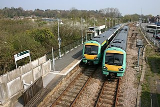
The Marshlink line is a railway line in South East England. It runs from Ashford, Kent via Romney Marsh, Rye and the Ore Tunnel to Hastings, connecting to the East Coastway line towards Brighton.

Greatstone Dunes railway station

Greatstone Dunes railway station was a station on the Romney, Hythe and Dymchurch Railway in Kent, England.

Dungeness railway station (South Eastern Railway) former building on SER line in Kent

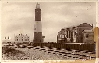
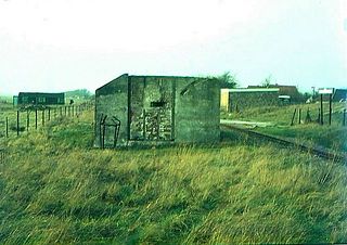
Dungeness was a railway station which served the Dungeness headland in Kent, England. Opened in 1883 by The Lydd Railway Company, it closed to passengers in 1937. Part of the line which served the station is converted to the main access road as a means of transporting atomic waste from nearby Dungeness nuclear power station.

Lydd-on-Sea village in United Kingdom

Lydd-on-Sea is a modern village, mostly built after World War II, which consists mainly of bungalows built along the Dungeness coastal road south of Greatstone, Kent, England. The Southern Railway opened a railway station here in 1937 but was closed in 1967. Lydd-on-Sea is part of the ecclesiastical parish of Lydd, now several miles distant, which once had access to the sea.

Stagecoach in East Kent, which forms part of Stagecoach South East, operate many routes within the East Kent region. The company operate both frequent town routes to infrequent rural service; for example the Thanet Loop runs about every 7 minutes on Mondays to Fridays compared to the 123, which has just 4 journeys on Weekdays. The company have introduced a large number of new buses in the past few years to meet with the step free access law on buses which came into place in January 2017.

Lydd Town railway station

Lydd Town was a railway station which served the town of Lydd in Kent, England. Opened on 7 December 1881 by The Lydd Railway Company. It closed to passengers in 1967 but the line through the station remained open for freight.

Lydd-on-Sea Halt railway station

Lydd-on-Sea Halt was a railway station which served the modern village of Lydd-on-Sea in Kent, England. The station opened in 1937 and closed in 1967.

Greatstone-on-Sea Halt railway station

Greatstone-on-Sea Halt was a railway station which served the modern village of Greatstone-on-Sea in Kent, England. The station opened in 1937 and closed in 1967.

New Romney and Littlestone-on-Sea railway station

New Romney and Littlestone-on-Sea was a railway station which lay in between the villages of New Romney and Littlestone-on-Sea in Kent, England. The station opened in 1884 and closed in 1967.

All Saints Church, Lydd Church in Kent, England

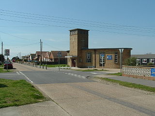
All Saints' Church, also known as Lydd Church or The Cathedral on the Marsh, is a church in Lydd, Kent, South East England. It belongs to the Diocese of Canterbury. All Saints is the longest parish church in Kent at 199 feet (61 m), and also has one of the tallest towers in the county at 132 feet (40 m). The church is thought to incorporate a small Romano-British basilica possibly built in the 5th century, though most of the current fabric is medieval. It was associated with local fraternities or guilds in the 15th century and could seat 1,000 people at a time. Severely damaged by World War II bombing, the church was subsequently restored and is now a Grade I listed building.

Rhee Wall

The Rhee Wall is a former watercourse in Romney Marsh in Kent. It is 7.5 miles (12.1 km) long and runs from Appledore, on the north-western edge of Romney Marsh, south-east through Snargate, Brenzett and Old Romney, to New Romney near the coast. The Rhee Wall forms a boundary between Romney Marsh proper, to the north-east, and Walland Marsh to the south-west.

Folkestone & Hythe District Council is the local authority for the Folkestone & Hythe district in Kent, which was known as Shepway until 2018.

References

  1. One-inch map of Great Britain: Sheet 184, Hastings. Ordnance Survey 1969.
  2. Romney Marshes Natural England, accessed 3 Nov 2014.
  3. History of Romney Marsh The Romney Marsh.net, accessed 3 Nov 2014.
  4. History:Sound Mirrors, greatstone.net, accessed 3 Nov 2014.

Coordinates: 50°56′15″N0°55′15″E / 50.93750°N 0.92083°E / 50.93750; 0.92083

Geographic coordinate system Coordinate system

A geographic coordinate system is a coordinate system that enables every location on Earth to be specified by a set of numbers, letters or symbols. The coordinates are often chosen such that one of the numbers represents a vertical position and two or three of the numbers represent a horizontal position; alternatively, a geographic position may be expressed in a combined three-dimensional Cartesian vector. A common choice of coordinates is latitude, longitude and elevation. To specify a location on a plane requires a map projection.