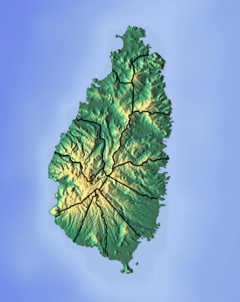
Saint Lucia is one of many small land masses composing the insular group known as the Windward Islands. Unlike large limestone areas such as Florida, Cuba, and the Yucatan Peninsula, or the Bahamas, which is a small island group composed of coral and sand, St. Lucia is a typical Windward Island formation of volcanic rock that came into existence long after much of the region had already been formed.

A flood is an overflow of water that submerges land that is usually dry. In the sense of "flowing water", the word may also be applied to the inflow of the tide. Floods are an area of study of the discipline hydrology and are of significant concern in agriculture, civil engineering and public health. Human changes to the environment often increase the intensity and frequency of flooding, for example land use changes such as deforestation and removal of wetlands, changes in waterway course or flood controls such as with levees, and larger environmental issues such as climate change and sea level rise. In particular climate change's increased rainfall and extreme weather events increases the severity of other causes for flooding, resulting in more intense floods and increased flood risk.

Storm tides of the North Sea are coastal floods associated with extratropical cyclones crossing over the North Sea, the severity of which are affected by the shallowness of the sea and the orientation of the shoreline relative to the storm's path, as well as the timing of tides. The water level can rise to more than 5 metres (17 ft) above the normal tide as a result of storm tides.

Dennery District is one of 10 districts of the Caribbean island nation of Saint Lucia. The seat of Dennery District is the Dennery Village. The main economic activities are fishing, and the cultivation of lima beans, bananas, and other tropical fruit. The population of the quarter was estimated at 12,876 in 2002 and fell to 12,767 in 2010.
The island nation of Saint Lucia is divided into 10 districts. The name Quarters or Quartiers originally came from the French period in Saint Lucia. The 2001 and 2010 Census of Saint Lucia refers to the first level administrative divisions as districts. The FIPS and ISO standards regularly called these divisions quarters or quartiers in French. The former district of Dauphin Quarter was merged into Gros Islet District and the former district of Praslin Quarter was merged into Micoud District.

The Girl Guides Association of Saint Lucia is the national Guiding organisation of Saint Lucia. It serves 2,181 members. Founded in 1925, the girls-only organisation became a full member of the World Association of Girl Guides and Girl Scouts in 1984. It is a member organisation of the Caribbean Link for Guiding.

The Cul De Sac River is a river in Castries Quarter of the island country of Saint Lucia. It flows north and then west from the central highlands in the south of the island, reaching the Caribbean Sea in Grand Cul de Sac Bay, south of the capital, Castries. It is one of the longest rivers in Saint Lucia.

The effects of Hurricane Dean in the Lesser Antilles were spread over five island countries and included 3 fatalities. Hurricane Dean of the 2007 Atlantic hurricane season formed in the Atlantic Ocean west of Cape Verde on August 14, 2007. The National Hurricane Center's first Forecast Advisory on the system anticipated that the Cape Verde-type hurricane would pass into the Caribbean through the Lesser Antilles. The storm moved persistently towards the small island chain, strengthening until it passed through the islands three days later on August 17 as a Category 2 hurricane on the Saffir-Simpson Hurricane Scale. It went on to brush the island of Jamaica and reached Category 5 strength before making landfall on Mexico's Yucatán Peninsula.

The Balembouche River is a coastal river in Laborie Quarter, Saint Lucia that flows into the Caribbean Sea.

The Dorée River is a river on the island of Saint Lucia.
The Migny River is a river on the island of Saint Lucia.

Flood control methods are used to reduce or prevent the detrimental effects of flood waters. Flood relief methods are used to reduce the effects of flood waters or high water levels. Flooding can be caused by a mix of both natural processes, such as extreme weather upstream, and human changes to waterbodies and runoff. Though building hard infrastructure to prevent flooding, such as flood walls, can be effective at managing flooding, increased best practice within landscape engineering is to rely more on soft infrastructure and natural systems, such as marshes and flood plains, for handling the increase in water. For flooding on coasts, coastal management practices have to not only handle changes water flow, but also natural processes like tides.
The Dauphin River is a river in Gros Islet Quarter, Saint Lucia.
The Ger River is a river of Saint Lucia.
The La Verdure River is a river of Saint Lucia.
The Mamiku River is a river of Saint Lucia.
The Millet River is a river of Saint Lucia.
The Trou Sallé River is a river of Saint Lucia.
The Volet River is a river of Saint Lucia.