
Denning is a quarter of the Bavarian capital Munich that belongs to district 13 Bogenhausen.
Denning is a quarter of the Bavarian capital Munich that belongs to district 13 Bogenhausen.
Denning is located in the eastern part of Bogenhausen urban district between Englschalking in the north and Zamdorf in the south. The historic city center is located at the intersection between the east-west axis formed by Denninger and Daglfinger Straße and the north-south axis formed by Friedrich-Eckart-Straße and Ostpreußenstraße. The borders of Denning are the Vollmannstraße in the west, the Memeler Straße in the north, the S-Bahn line in the east and the Denninger Anger in the south. [1]
The Denning area was settled during the Roman period around the end of the first to the middle of the third century CE. A relic of the Roman past of Denning is a villa rustica with its own bathhouse. [2] It was excavated in 1928.
In official documents, Denning was first mentioned in 1200 as Tenningen or Danningen, which probably refers to the personal name Tenno. [3]
Around 1800, Denning was a hamlet with four farms, of which only the Alte Kernhof is preserved, along with the Guardian Angel Chapel. One of the courtyards and the Guardian Angel Chapel were demolished in the 1950s. The other two courtyards were demolished around the end of the 1970s, due to the relocation of the Daglfinger Straße. [1]
When the village was incorporated into Bavaria in 1818, Denning initially formed the independent municipality Zamdorf with Zamdorf and Steinhausen, which was incorporated in 1820 into the community Daglfing. An application by Denning to be converted to Bogenhausen was rejected in 1873 by the presiding authorities.
The Obermaier Kiesquetschwerks was mined in the 19th century for brick production for Munich's growing construction industry. For example, the Ludwigskirche was built with bricks burned in Denning. After the clay was exhausted, the pits were used for gravel extraction.
At the end of the 19th century, eight properties were in Denning. Settlement activity began in 1924. East of today's Ostpreußenstraße to today's Platz Zur Deutschen Einheit ('place for German unity') was the Obermaiersche colony, named after the lead contractor. From 1926, the Denning colony arose west of today's Ostpreußenstraße. The number of houses increased to 140 by 1930 when Daglfing was incorporated on 1 January into Munich. [4]
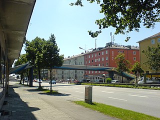
At the end of the 1960s, the Denninger Straße-Warthestraße was built up with four to eight-story residential developments south of the Denninger Straße, which were also called Denninger Hochhäuser (Denninger skyscrapers) due to the otherwise lower development of Denning. [5]
Following the quarry's closure, the unused gravel plant stood on Denninger Straße until approximately 2000, more precisely on the Pühnstraße. In a dilapidated state, it was demolished and converted to recreation and nature.
An almost two-meter-thick layer of clay lies beneath a thin layer of humus.

Denning is characterized by residential areas with single-family homes surrounded by gardens. Skyscrapers are found in the settlement Denninger Straße-Warthestraße at the southern end of Denning. The oldest remaining property in Denning is the restaurant Alter Kernhof on the corner of Ostpreußen-Denninger Straße.
The main thoroughfare in Denning is the Ostpreußenstraße, which holds more than 100 shops and service companies. [6] Restaurants and a pub are there.
In the core area of Denning are found small parks such as that at Posener Platz or at the Platz Zur Deutschen Einheit. Therefore, the Denninger Anger extends along the entire southern border of Denning. In the west, a green band runs in the north-south direction. In the Denninger Anger, at the Denninger Straße 190, the gravel plant's administrative building is the last reminder. [3]
Since the demolition of the Guardian Angel Chapel in 1953, no Roman Catholic church building is in Denning. However, the Catholic parish church of St. Emmeram in the neighboring Englschalking district is located on the Ostpreußenstraße a few meters from the border between the two districts. Near the same border on the Denninger side, is the Protestant-Lutheran Immanuel Church on the Memeler Straße. [1]
The Munich U-Bahn is an electric rail rapid transit network in Munich, Germany. The system began operation in 1971, and is operated by the municipally owned Münchner Verkehrsgesellschaft. The network is integrated into the Münchner Verkehrs- und Tarifverbund and interconnected with the Munich S-Bahn. The U-Bahn currently comprises eight lines, serving 96 stations, and encompassing 103.1 kilometres (64.1 mi) of routes.

Hellersdorf is a locality in the borough of Marzahn-Hellersdorf in Berlin. Between 1986 and Berlin's 2001 administrative reform, it was a borough in its own right, consisting of the current area of Hellersdorf as well as Kaulsdorf and Mahlsdorf.

Bogenhausen is the 13th borough of Munich, Germany. It is the geographically largest borough of Munich and comprises the city's north-eastern quarter, reaching from the Isar on the eastern side of the Englischer Garten to the city limits, bordering on Unterföhring to the north, Aschheim to the east and the Haidhausen borough to the south.

Altstadt and Lehel are districts of the German city of Munich. Together they form the first borough of the city: Altstadt-Lehel.

Au-Haidhausen is the 5th borough of the German city of Munich, Bavaria. It is formed by the Au and Haidhausen districts.

Trudering-Riem is the 15th borough of Munich, Bavaria. It consists of the two quarters Trudering and Riem. The borough is the location of Munich's former airport, Riem Airport.

Thalkirchen-Obersendling-Forstenried-Fürstenried-Solln is the 19th borough of Munich, Germany, comprising the extreme southern part of the city on the west bank of the river Isar. After the administrative reform, the boroughs Thalkirchen-Obersendling-Forstenried and Solln were incorporated, thus forming the new borough. It comprises 17.7631 square kilometres and has a population of 96,714 residents.

Haidhausen is a quarter in Munich, Germany. It is now part of the borough of Au-Haidhausen.

Schleißheimer Straße is the second longest street in Munich after Dachauer Straße with a length of 8.14 km. It starts in the city centre at Stiglmaierplatz, leads through five districts and ends at Goldschmiedplatz. It takes its name from the northern suburb of Oberschleißheim, where it originally ended.
The Munich East–Munich Airport railway is a double-track and electrified main line in the German state of Bavaria that connects the city of Munich to Munich Airport, which is located 30 kilometres to the northeast. It is operated of DB Netz AG and integrated in the Munich S-Bahn as part of line S 8.
The Tegernseer Landstraße is a street in the Obergiesing borough of Munich, Germany, which runs in a southeastern direction and is a total of 4.6 kilometers long. It begins in the north as a straight extension of the Regerstraße, where it is a regular two-lane road until the Tegernseer Platz. At the Tegernseer Platz, a large branch of the Deutsche Post can be found. The building, nicknamed Tela-Post, was built in 1928 in the architectural style New Objectivity. The Hertie-store, which was located at the Tegernseer Platz until the summer of 2009, was closed because of insolvency and demolished in 2010. Between 1976 and 2016, a branch of the city library was located across the street. There are efforts to strengthen the local economy and prevent vacancy of retail spaces around the Tegernseer Landstraße, which are funded by the federal government.

Paul Pfann was a German architect in the Historicist style. He was also a professor at the Technical University of Munich.

The Türkenstraße is an inner city street in Munich's district Maxvorstadt. It is named after the Türkengraben to which it ran. In the list of historical monuments in Munich, more than 30 objects are listed in the Türkenstraße.

The Lindwurmstraße is a 2.4-kilometer poplar alley in the Munich districts Ludwigsvorstadt-Isarvorstadt and Sendling.

The Munich Old Town is part of the Bavarian capital Munich and has belonged to the city the longest, even if some places which are meanwhile districts of Munich, were mentioned long before Munich's documents spoke of the Old Town. The Old Town forms together with the district Lehel, the municipality No. 1 Altstadt-Lehel. The entire area of the Old Town is listed as both a historical ensemble as well as a historical monument listed in the Bavarian historical monument list.

The Ismaninger Straße is a city center, entrance and exit road in Munich.

Englschalking is a quarter of the Bavarian capital Munich and belongs to the district 13 Bogenhausen.

The Petuelring is an approximately 2.2 km long road in the north of Munich and part of the Mittlerer Ring. It runs between Georg-Brauchle-Ring and Schenkendorfstraße.

Leonrodplatz is a square in the Munich district of Neuhausen. It was named in 1927 after the former Bavarian Minister of Justice Leopold von Leonrod.