Englschalking is a quarter of the Bavarian capital Munich and belongs to the district 13 Bogenhausen. [1]
Englschalking is a quarter of the Bavarian capital Munich and belongs to the district 13 Bogenhausen. [1]
Englschalking is located relatively central in the district of Bogenhausen. The historic town centre lies northeast of the intersection Englschalkinger Straße/Ostpreußenstraße. In the east Englschalking has developed beyond the Munich East–Munich Airport railway to Max-Nadler-Straße, in the south it is bordered by Memeler Straße and Englschalkinger Straße, in the west by Cosimastraße and the area of the former Prinz-Eugen-Kaserne and in the north by Fideliostraße. [2]

In the area of Stegmühlstraße/Rambaldistraße, end Stone Age burials and an Early Bronze Age cemetery were discovered during excavations by the Bavarian State Office for Monument Protection in 1983. [3] At the northern edge of Englschalking, south of Stegmühlstraße and east of the Munich S-Bahn, there was a settlement from the Early Middle Ages excavated in 1983. A residential house, an iron smelter, fountain, barns, stables and a cemetery in which 34 burials are documented were found. Jewellery that was found allowed historians to date it back to the 7th century. The foundation of Englschalking is assumed to date back to the 9th or 10th century. Englschalking was first mentioned in a document in 1231/1234 in the Bavarian Duke's urbarium (medieval register of ownership rights of a landlordate). [4] The name is derived from Engelschalch (strict servant) or Englischalcho (also Engilschalko). In 1319 the hamlet of Englschaling was sold by Duke Ludwig to the Hochstift Freising, to which it belonged until secularization in 1803 as part of the county of Ismaning. [1] When the community was included into Bavaria in 1818, Englschalking became part of the community of Daglfing. [4]
Most of the buildings in the historic town centre date back to the end of the 19th century. Englschalking achieved some prosperity through the cultivation of moss and brickworks, in which the bricks used in construction in Munich were fired from the clay extracted here. [5]
At the beginning of the 20th century, Englschalking developed into the central town of the municipality of Daglfing, partly because a municipal school was opened in 1896 on what is now Schnorr-von-Carolsfeld-Straße. Along with the municipality of Daglfing, Englschalking was incorporated into the city of Munich on 1 January 1930. [6]


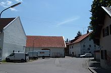
The historic centre of Englschalking is a good example of a Haufendorf (ancient heap village). Large farmsteads stand in irregular arrangement around the church of Saint Nicholas, dating back to the 13th century. [4] This village centre, which is a historically listed ensemble of buildings, is about the same size as the village was in the early 19th century.
South of the town centre and Englschalkinger Straße lies the large primary school building on Ostpreußenstraße, a 1930s work by Hermann Leitenstorfer. The original village school, built in the 19th century as a community school for the community of Daglfing on the eastern edge of the old town centre, now serves as a kindergarten. The parish church of Saint Emmeram is also located on Ostpreußenstraße.
To the west of the town centre lies Fideliopark, [7] built in 1966-1970, with three to nineteen-storey apartment blocks. Further west is Cosimapark, [8] built between 1964 and 1969, with four-storey apartment blocks and ten to nineteen-storey skyscrapers surrounded by balconies. On both sides of the railway line, extensive single-family house estates and estates with multi-family houses (such as the Barlowstraße estate) have been built since 1978. [9]

The railway line from Munich East–Munich Airport runs through Englschalking and every 20 minutes the S8 line of the Munich S-Bahn from Herrsching to Munich Airport travels there. The double-track S-Bahn station München-Englschalking, equipped with side-rail platforms, is located here.
The tram line to Saint Emmeram which opened in 2011, [10] touches Englschalking along Cosimastraße. Currently, line 16 runs on it with connections to Bogenhausen (Arabellapark, Effnerplatz, Herkomerplatz, Ismaninger Straße), to Haidhausen (Klinikum rechts der Isar, Max-Weber-Platz, Wiener Platz, Gasteig, Müllersches Volksbad) and to the city centre.
The underground line U4 from the city centre does not quite reach Englschalking, but is well connected with three bus lines and one tram line to the Arabellapark terminal.
There are plans to extend the underground line 4 from the current end terminal Arabellapark via Fidelio Park to the Englschalking S-Bahn station. The journey time between Bogenhausen and the Munich Airport would be shortened by a few minutes. However, critics are sceptical about extending the rather underutilized U4. Some of the calculated passenger growth has already been absorbed by the new tram line, so that the extension of the subway is currently postponed. [11]
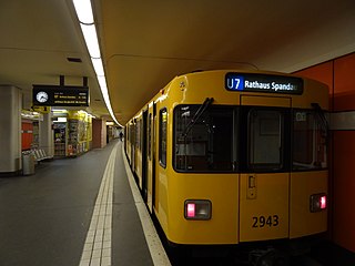
The U7 is a rail line on the Berlin U-Bahn. It runs completely underground for a length of 31.8 kilometres (19.8 mi) through 40 stations and connects Spandau, via Neukölln, to Gropiusstadt and Rudow. The U7 was originally the south-eastern branch of the Nord-Süd-Bahn (U6) that ran between the branching point at Belle-Alliance-Straße (Mehringdamm) and Grenzallee; however, in the 1960s, this stretch was separated from the rest of the line and extended at each end to form a new line.
The Munich U-Bahn is an electric rail rapid transit network in Munich, Germany. The system began operation in 1971, and is operated by the municipally owned Münchner Verkehrsgesellschaft. The network is integrated into the Münchner Verkehrs- und Tarifverbund and interconnected with the Munich S-Bahn. The U-Bahn currently comprises eight lines, serving 96 stations, and encompassing 103.1 kilometres (64.1 mi) of routes.

Ismaning is a municipality in Bavaria, Germany, located near Munich.

München Hauptbahnhof or Munich Central Station is the main railway station in the city of Munich, Germany. It is one of the three stations with long-distance services in Munich, the others being Munich East station and Munich-Pasing station (München-Pasing). München Hauptbahnhof sees about 450,000 passengers a day, which puts it on par with other large stations in Germany, such as Hamburg Hauptbahnhof and Frankfurt (Main) Hauptbahnhof. It is classified by Deutsche Bahn as a category 1 station, one of 21 in Germany and two in Munich, the other being München Ost. The mainline station is a terminal station with 32 platforms. The subterranean S-Bahn with 2 platforms and U-Bahn stations with 6 platforms are through stations.

Munich-Pasing is a railway station in the west of Munich. It is the third-largest station in the city, after München Hauptbahnhof and München Ost.

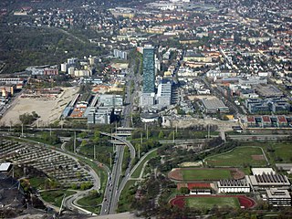
Arabellapark is a Munich U-Bahn station in Bogenhausen borough. It is the eastern terminus of the U4. Arabellapark station is located in the Arabellapark district of Bogenhausen, a large housing and commercial district developed during the 1970s. Arabellapark station serves as an important bus interchange station for buses servicing Bogenhausen. It is the terminus of bus lines 183, 184, 185 and 187.

Richard-Strauss-Straße is a Munich U-Bahn station on the U4 line in the borough of Bogenhausen. It is located on the eastern fringe of Alt-Bogenhausen, the traditional core district. The station takes its name from Richard-Strauss-Straße, part of the Mittlerer Ring road system, that runs above the U-Bahn tracks, which was named for the famed German composer Richard Strauss. The station is serviced by the bus lines 59, 187, 188 and 189. Additionally, this subway station is one of three U-Bahn stations to have separate platforms at the either side of tracks rather than one in the middle serving both directions.

Munich-Trudering station is an interchange station of the Munich S-Bahn and the Munich U-Bahn in the borough of Trudering-Riem in the Bavarian capital of Munich.

Bogenhausen is the 13th borough of Munich, Germany. It is the geographically largest borough of Munich and comprises the city's north-eastern quarter, reaching from the Isar on the eastern side of the Englischer Garten to the city limits, bordering on Unterföhring to the north, Aschheim to the east and the Haidhausen borough to the south.

Munich Rosenheimer Platz station is one five underground station opened in 1972 on the trunk line of the Munich S-Bahn between Munich Central Station and Munich East station. It is under the street of the same name and Rosenheimerstraße in the Munich district of Haidhausen. It has two platform tracks and is classified by Deutsche Bahn as a category 4 station.

Munich-Englschalking is a Munich S-Bahn station on the Munich East–Munich Airport railway in the borough of Bogenhausen.

The Munich tramway is the tramway network for the city of Munich in Germany. Today it is operated by the municipally owned Münchner Verkehrsgesellschaft and is known officially and colloquially as the Tram. Previous operators have included Société Anonyme des Tramways de Munich, the Münchner Trambahn-Aktiengesellschaft, the Städtische Straßenbahnen and the Straßenbahn München.

Schleißheimer Straße is the second longest street in Munich after Dachauer Straße with a length of 8.14 km. It starts in the city centre at Stiglmaierplatz, leads through five districts and ends at Goldschmiedplatz. It takes its name from the northern suburb of Oberschleißheim, where it originally ended.
Moosach is the 10th northwestern district of Munich, Bavaria, Germany. It is sectioned in the urban districts Hartmannshofen, Pressestadt and Borstei.
The Munich East–Munich Airport railway is a double-track and electrified main line in the German state of Bavaria that connects the city of Munich to Munich Airport, which is located 30 kilometres to the northeast. It is operated of DB Netz AG and integrated in the Munich S-Bahn as part of line S 8.

The Erding ring closure is a project to build a 30.2-kilometre (18.8 mi) long, double-track railway that is planned to run from Freising via Munich Airport to Erding.

The following outline is provided as an overview of and topical guide to Munich:

Denning is a quarter of the Bavarian capital Munich that belongs to district 13 Bogenhausen.

The Ismaninger Straße is a city center, entrance and exit road in Munich.