
Kanzaki is a district located in Hyōgo Prefecture, Japan.

The Protestant Seminaries of Maulbronn and Blaubeuren in Baden-Württemberg, Germany, are two Gymnasien and Protestant boarding schools in the Württemberg tradition.

Basaburua is a town and municipality located in the province and autonomous community of Navarre, northern Spain.

Přelovice is a small village in the Pardubice Region of the Czech Republic. It has around 190 inhabitants.
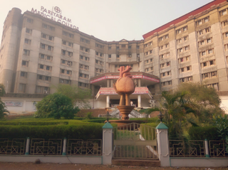
Government Medical College Kannur, Pariyaram or Pariyaram Medical College was established in March 1993 at Pariyaram in Kannur district, Kerala state, South India. It was the first medical college to be established under the co operative sector in India and was then called Academy of Medical Sciences (ACME).
Cypress is an unincorporated community in Jackson County, Florida, United States. It is located near the intersection of U.S. Route 90 and County Road 275, west of Grand Ridge.
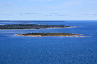
Hõralaid is a small, uninhabited Estonian island of approximately 20 hectares in the Baltic Sea. The coordinates of Hõralaid are 58°53′55″N23°04′26″E.
Biogno is a village and former municipality in the canton of Ticino, Switzerland.
The canton of Villars-les-Dombes is an administrative division in eastern France. At the French canton reorganisation which came into effect in March 2015, the canton was expanded from 10 to 25 communes:
Wielki Bór is a settlement in the administrative district of Gmina Giby, within Sejny County, Podlaskie Voivodeship, in north-eastern Poland, close to the borders with Belarus and Lithuania. It lies approximately 13 kilometres (8 mi) south of Sejny and 99 km (62 mi) north of the regional capital Białystok.
Puczniew-Leonów is a village in the administrative district of Gmina Lutomiersk, within Pabianice County, Łódź Voivodeship, in central Poland. It lies approximately 10 kilometres (6 mi) north-west of Lutomiersk, 27 km (17 mi) north-west of Pabianice, and 28 km (17 mi) west of the regional capital Łódź.
Tremica is an archaeological site in Corsica. It consists of a dolmen with a semicircular capstone, and is located above the village of Casaglione.
Dzierżążnik is a village in the administrative district of Gmina Korsze, within Kętrzyn County, Warmian-Masurian Voivodeship, in northern Poland.
Diamond Lake is the name of at least nine different lakes in Ontario, Canada:
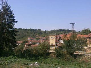
Gradašnica is a village in the municipality of Leskovac, Serbia. According to the 2002 census, the village has a population of 472 people.
Refuge alpin du Tour is a refuge in the Alps in France.
Waco is a populated place and former town site located in Yellowstone County, Montana, United States. The elevation is 2,785 feet (849 m).

The Tartarus Montes are a mountain range on the planet Mars, stretching over 1070 km and located around the coordinates 15.46º N, 167.54º E, between Orcus Patera and the Elysium volcanic region.
Mount Sterling is an unincorporated community in Jefferson Township, Switzerland County, in the U.S. state of Indiana.
Surveyor is an unincorporated community in Clearfield County, in the U.S. state of Pennsylvania.
This page is based on this
Wikipedia article Text is available under the
CC BY-SA 4.0 license; additional terms may apply.
Images, videos and audio are available under their respective licenses.
