| Deoksungsan | |
|---|---|
 | |
| Highest point | |
| Elevation | 495 m (1,624 ft) |
| Geography | |
| Location | Chungcheongnam-do, South Korea |
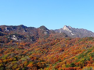
Deoksungsan is a mountain of Chungcheongnam-do, western South Korea. It has an elevation of 495 metres (1,624 feet). [1]
| Deoksungsan | |
|---|---|
| | |
| Highest point | |
| Elevation | 495 m (1,624 ft) |
| Geography | |
| Location | Chungcheongnam-do, South Korea |
Deoksungsan is a mountain of Chungcheongnam-do, western South Korea. It has an elevation of 495 metres (1,624 feet). [1]
Buddhist temples are an important part of the Korean landscape. Most Korean temples have names ending in -sa, which means "monastery" in Sino-Korean. Many temples participate in the Templestay program, where visitors can experience Buddhist culture and even stay at the temple overnight.

Buyeo County (Buyeo-gun) is a county in South Chungcheong Province, South Korea. Buyeo-eup, the county's capital, was the site of the capital of Baekje from 538-660 AD, during which it was called Sabi Fortress.

Yesan is a county in South Chungcheong Province, South Korea. Famous people from Yesan include independence fighter Yoon Bong-Gil.

Gimcheon is a city in North Gyeongsang Province, South Korea. It is situated on the major land transportation routes between Seoul and Busan, namely the Gyeongbu Expressway and Gyeongbu Line railway.
Bongwonsa is a South Korean Buddhist temple in Bongwon-dong, Seodaemun District, Seoul, South Korea.

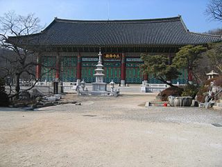
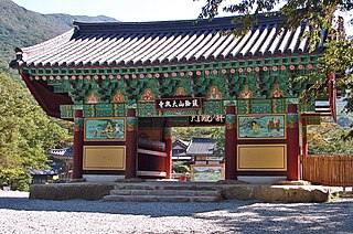
Sudeoksa (Korean: 수덕사) is a head temple of the Jogye Order of Korean Buddhism. It is located on the southern slopes of Deoksungsan in Deoksan-myeon, Yesan County, South Chungcheong Province, South Korea.
Daeheungsa (Korean: 대흥사), sometimes called Daedunsa, is a main temple of the Jogye Order of Korean Buddhism. Daeheungsa is located on the slopes of Duryunsan in Samsan township, Haenam County, South Jeolla Province, South Korea.

The White Deer Grotto Academy is a former school at the foot of Wulou Peak in Mount Lu, now in Jiujiang. It was one of the Four Great Academies of China, and today it is maintained as an important landmark.
Dalmasan, Mt. Dalma, is part of the Taebaek mountain range and lies in Haenam county, South Jeolla province, South Korea. Its elevation is 489 meters, and its peak offers views of the "Land's Edge," (땅끝) the southernmost point on the Korean peninsula, 땅끝마을, and outlying islands such as Wando. Also in the vicinity are Mihwangsa and a number of hermitages affiliated with it.

Fenaia Il Maten, or Ifenain Ilmathen is a commune in northern Algeria in the Béjaïa Province. The Béni Mansour-Bejaïa line traverses this community.

Mihwangsa (Korean: 미황사) is a Buddhist temple on Dalmasan, nicknamed ‘Geumgangsan of the Korean peninsula, Haenam County, South Jeolla Province, South Korea.

Bulgwang-dong (Korean: 불광동) is a neighborhood (dong) of Eunpyeong District, Seoul, South Korea.

Gamaksan, also known as Kamak Mountain or Hill 675 (675고지) during the Korean War, is a mountain in Gyeonggi Province, South Korea. Its sits between the cities of Paju, Yangju and Yeoncheon County. Gamaksan has an elevation of 675 m (2,215 ft).
Seounsan is a mountain in South Korea. Its area extends across the city of Anseong, Gyeonggi Province and Jincheon County, North Chungcheong Province. It has an elevation of 547.7 m (1,797 ft). Seounsan translates as "West Clouds Mountain". The Cheongryongsa or "Blue Dragon Temple" is located on the Southern slope of the mountain.

Iwon station is a railway station on the Gyeongbu Line in South Korea. It is located at Gangcheong-ri, Iwon-myeon, Okcheon-gun, Chungcheongbuk Province. It crosses the Gyeongbu Line which is managed by KORAIL. The station also operates trains on an interim basis for a memorial for railroad workers who died, which is located nearby.
Mansusan is a mountain of Chungcheongnam-do, western South Korea. It has an elevation of 575 metres.
Oseosan is a mountain of Chungcheongnam-do, western South Korea. It has an elevation of 791 metres.
Bohyeonsan or Bohyeon Mountain or Mount Bohyeon is located in the province of North Gyeongsang Province, eastern South Korea. Its peak has an elevation of 1,121 metres (3,678 ft), and is near the city of Yeongcheon.

Historic site of Seongjusa temple is no.307 South Korean historic site in Boryeong City, South Chungcheong Province built in Baekje era. According to Samguksagi, The temple was said to be built by King Beop of Baekje around 600 and played critical role as Nine mountain schools during North South States Period in Silla. but whole structures were arsoned during Japanese invasion of Korea in late 16th century. However, Stele accompanying pagoda of Buddhist priest Nanghyehwasang still remains including pieces of Buddhist statue of Baekje and several roof tiles in the era of Unified Silla. The stele is registered as the national treasure of South Korea in the present time. The pagoda cherished the most fabulous architectural style with magnificent scale during Unified Silla.
36°40′18″N126°37′05″E / 36.67167°N 126.61806°E
| | This South Korea location article is a stub. You can help Wikipedia by expanding it. |