
The M25 or London Orbital Motorway is a major road encircling most of Greater London. The 117-mile (188-kilometre) motorway is one of the most important roads in the UK and one of the busiest. Margaret Thatcher opened the final section in 1986, making the M25 the longest ring road in Europe upon opening. The Dartford Crossing completes the orbital route but is not classed as motorway; it is classed as a trunk road and designated as the A282. In some cases, including notable legal contexts such as the Communications Act 2003, the M25 is used as a de facto alternative boundary for Greater London.

A road is a thoroughfare for the conveyance of traffic that mostly has an improved surface for use by vehicles and pedestrians. Unlike streets, whose primary function is to serve as public spaces, the main function of roads is transportation.

Highways in Australia are generally high capacity roads managed by state and territory government agencies, though Australia's federal government contributes funding for important links between capital cities and major regional centres. Prior to European settlement, the earliest needs for trade and travel were met by narrow bush tracks, used by tribes of Indigenous Australians. The formal construction of roads began in 1788, after the founding of the colony of New South Wales, and a network of three major roads across the colony emerged by the 1820s. Similar road networks were established in the other colonies of Australia. Road construction programs in the early 19th century were generally underfunded, as they were dependent on government budgets, loans, and tolls; while there was a huge increase in road usage, due to the Australian gold rushes. Local government authorities, often known as Road Boards, were therefore established to be primarily responsible for funding and undertaking road construction and maintenance. The early 1900s saw both the increasingly widespread use of motorised transportation, and the creation of state road authorities in each state, between 1913 and 1926. These authorities managed each state's road network, with the main arterial roads controlled and maintained by the state, and other roads remaining the responsibility of local governments. The federal government became involved in road funding in the 1920s, distributing funding to the states. The depression of the 1930s slowed the funding and development of the major road network until the onset on World War II. Supply roads leading to the north of the country were considered vital, resulting in the construction of Barkly, Stuart, and Eyre Highways.

A trunk road is a major highway with a specific legal classification in some jurisdictions, notably the United Kingdom, Sweden and formerly Ireland. Trunk roads are planned and managed at the national-level, distinguishing them from non-trunk roads which are managed by local authorities. Trunk roads are important routes usually connecting two or more cities, ports, airports and other places, which is the recommended route for long-distance and freight traffic. Many trunk roads have segregated lanes in a dual carriageway, or are of motorway standard.

The M32 is a 4.42 miles (7.11 km) long motorway in South Gloucestershire and Bristol, England. It provides a link from the M4, a major motorway linking London and South Wales, to Bristol city centre and is maintained by National Highways, the national roads body.
National Highways (NH), formerly the Highways Agency and later Highways England, is a government-owned company charged with operating, maintaining and improving motorways and major A roads in England. It also sets highways standards used by all four UK administrations, through the Design Manual for Roads and Bridges. Within England, it operates information services through the provision of on-road signage and its Traffic England website, provides traffic officers to deal with incidents on its network, and manages the delivery of improvement schemes to the network.
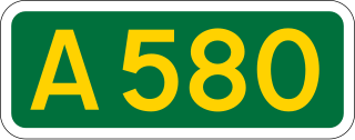
The A580 is the United Kingdom's first purpose-built A road. The road was officially opened by King George V on 18 July 1934. Despite its name, the actual road runs through the modern day metropolitan counties of Merseyside and Greater Manchester which were historically in Lancashire when the road was built until 1974. Notable towns and cities along the route include Liverpool, Kirkby, St. Helens, Leigh, Swinton and Salford.

A limited-access road, known by various terms worldwide, including limited-access highway, dual-carriageway, expressway, and partial controlled-access highway, is a highway or arterial road for high-speed traffic which has many or most characteristics of a controlled-access highway, including limited or no access to adjacent property, some degree of separation of opposing traffic flow, use of grade separated interchanges to some extent, prohibition of slow modes of transport, such as bicycles, horse-drawn vehicles or ridden horses, or self-propelled agricultural machines; and very few or no intersecting cross-streets or level crossings. The degree of isolation from local traffic allowed varies between countries and regions. The precise definition of these terms varies by jurisdiction.

The A419 road is a primary route between Chiseldon near Swindon at junction 15 of the M4 with the A346 road, and Whitminster in Gloucestershire, England near the M5 motorway. The A419 is managed and maintained by a private company, Road Management Group, on behalf of the UK Department for Transport.

A controlled-access highway is a type of highway that has been designed for high-speed vehicular traffic, with all traffic flow—ingress and egress—regulated. Common English terms are freeway, motorway, and expressway. Other similar terms include throughway or thruway and parkway. Some of these may be limited-access highways, although this term can also refer to a class of highways with somewhat less isolation from other traffic.

The GEH Statistic is a formula used in traffic engineering, traffic forecasting, and traffic modelling to compare two sets of traffic volumes. The GEH formula gets its name from Geoffrey E. Havers, who invented it in the 1970s while working as a transport planner in London, England. Although its mathematical form is similar to a chi-squared test, is not a true statistical test. Rather, it is an empirical formula that has proven useful for a variety of traffic analysis purposes.

The United Kingdom has a well developed and extensive network of roads totalling about 262,300 miles (422,100 km). Road distances are shown in miles or yards and UK speed limits are indicated in miles per hour (mph) or by the use of the national speed limit (NSL) symbol. Some vehicle categories have various lower maximum limits enforced by speed limiters. A unified numbering system is in place for Great Britain, whilst in Northern Ireland, there is no available explanation for the allocation of road numbers.

The Highways Act 1980 is an act of the Parliament of the United Kingdom dealing with the management and operation of the road network in England and Wales. It consolidated with amendments several earlier pieces of legislation. Many amendments relate only to changes of highway authority, to include new unitary councils and national parks. By virtue of the Local Government (Wales) Act 1994 and the Environment Act 1995, most references to local authority are taken to also include Welsh councils and national park authorities.

The Longdendale Bypass is a long-planned National Highways road scheme in the Tameside and High Peak districts in England. Its aim is to alleviate traffic congestion on the A57, A628, and A616 routes that presently pass through the villages. There is both support and opposition for this long-planned scheme, which will pass through the valley of Longdendale and part of the Peak District National Park.
The New Approach to Appraisal was the name given to a multi-criteria decision framework used to appraise transport projects and proposals in the United Kingdom. NATA was built on the well established cost–benefit analysis and environmental impact assessment techniques for assessing transport projects and proposals.

Ireland has an extensive network of public roads which connect all parts of the country with each other. Roads in Ireland are currently classified as motorways, National Primary routes, National secondary routes, Regional roads and Local roads. The introduction of this classification system began in 1977.

There have been routes and trackways in Ireland connecting settlements and facilitating trade since ancient times and the country now has an extensive network of public roads connecting all parts of the island.
Driver location signs are signs placed every 500 metres (550 yd) along each side of English motorways, and some other major English roads, to provide information that will allow motorists to know their precise location. As of July 2009, roads in England, but not Scotland, Wales or Northern Ireland, have these signs. This information might be useful in the event of an emergency or breakdown. They were first introduced in 2003, and they complement distance marker posts. Both types of sign display a unique location number. The number, although given without units, is the distance in kilometres from a designated datum location for the road, although signs meant for driver navigation are in miles.

A smart motorway, also known in Scotland as an intelligent transport system, is a section of motorway in the United Kingdom that employs active traffic management (ATM) techniques to increase capacity through the use of MIDAS technology including variable speed limits and occasionally hard shoulder running and ramp metering at busy times. They were developed at the turn of the 21st century as a cost-effective alternative to traditional carriageway widening, with intended benefits ranging from more reliable journey times to lower vehicle emissions. However, despite the risk of a collision occurring between two moving vehicles being found to be decreased, there has been an acknowledged rise in the incidence of collisions involving vehicles where at least one was stationary in the first few years following the widespread removal of the hard shoulder on the country's busiest sections of motorway. Smart motorways garnered intense criticism from politicians, police representatives and motoring organisations, particularly from 2020 onwards, after a surge in near miss incidents and dozens of fatalities were revealed, and as of April 2023, no new smart motorways will be built.

An integral bridge contains no expansion joints to accommodate enlargement due to increased temperature. Horizontal (axial) movements due to thermal expansion and braking loads are instead transferred to the fill adjacent to the abutment. The omission of the expansion joint removes a pathway for the penetration of chloride-bearing road salts to the bridge's sub-structure. In the United Kingdom there is a presumption that most new short to medium length bridges will be of the integral type.
