
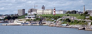
Devil's Point (also called Western King Point) is located on the eastern side of the mouth of the River Tamar where it meets the English Channel at Plymouth Sound. [1] [2]
Devil's Point (also called Western King Point) is located on the eastern side of the mouth of the River Tamar where it meets the English Channel at Plymouth Sound. [1] [2]
Devil's Point marks the southwest extremity of East Stonehouse in Plymouth. On the opposite western shore of the Tamar is Mount Edgcumbe Country Park. To the immediate north is the Royal William Yard.
The area features a public park with a wealth of historical features. [3]
For centuries, Devil's Point been used by friends and family to wave goodbye or welcome home to the crews of Royal Navy warships as they transit the narrow waters adjacent to Devil's Point. [4]

Also located at Devil's Point is Devil's Point Battery which was built between 1901 and 1902. It was armed with two 12–pounder Quick Firing guns. Both had been removed by 1936, but the positions remain today. [5]

Devon is a county in South West England, reaching from the Bristol Channel in the north to the English Channel in the south. It is bounded by Cornwall to the west, Somerset to the north-east and Dorset to the east. The city of Exeter is the county town. The county includes the districts of East Devon, Mid Devon, North Devon, South Hams, Teignbridge, Torridge and West Devon. Plymouth and Torbay are each geographically part of Devon, but are administered as unitary authorities. Combined as a ceremonial county, Devon's area is 6,707 km2 and its population is about 1.2 million.

Plymouth is a port city and unitary authority in South West England. It is located on the south coast of Devon, approximately 36 miles (58 km) south-west of Exeter and 193 miles (311 km) south-west of London. It is bordered by Cornwall to the west and south-west.
Plymouth Hoe, referred to locally as the Hoe, is a large south-facing open public space in the English coastal city of Plymouth. The Hoe is adjacent to and above the low limestone cliffs that form the seafront and it commands views of Plymouth Sound, Drake's Island, and across the Hamoaze to Mount Edgcumbe in Cornwall. The name derives from the Anglo-Saxon word hoh, a sloping ridge shaped like an inverted foot and heel.

The Tamar is a river in south west England, that forms most of the border between Devon and Cornwall. A part of the Tamar valley is a World Heritage Site due to its historic mining activities.
Devonport, formerly named Plymouth Dock or just Dock, is a district of Plymouth in the English county of Devon, although it was, at one time, the more important settlement. It became a county borough in 1889. Devonport was originally one of the "Three Towns" ; these merged in 1914 to form what would become in 1928 the City of Plymouth. It is represented in the Parliament of the United Kingdom as part of the Plymouth Sutton and Devonport constituency. Its elected Member of Parliament (MP) is Luke Pollard, who is a member of the Labour Party. The population of the ward at the 2011 census was 14,788.

Cawsand and Kingsand are twin villages in southeast Cornwall, England, United Kingdom. The village is situated on the Rame Peninsula and is in the parish of Maker-with-Rame.
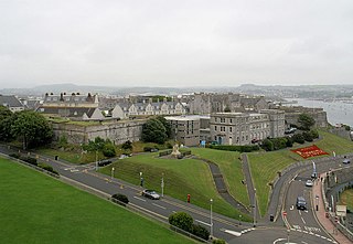
The Royal Citadel in Plymouth, Devon, England, was built in the late 1660s to the design of Sir Bernard de Gomme. It is at the eastern end of Plymouth Hoe overlooking Plymouth Sound, and encompasses the site of the earlier fort that had been built in the time of Sir Francis Drake.

Plymouth Breakwater is a 1,560-metre (1,710 yd) stone breakwater protecting Plymouth Sound and the anchorages near Plymouth, Devon, England. It is 13 metres (43 ft) wide at the top and the base is 65 metres (213 ft). It lies in about 10 metres (33 ft) of water. Around 4 million tons of rock were used in its construction in 1812 at the then-colossal cost of £1.5 million.
Barne Barton is an area within St Budeaux, Plymouth, Devon, England.

Whitsand Bay, situated in south east Cornwall, England, runs from Rame Head in the east to Portwrinkle in the west. It is characterised by sheer, high cliffs, dramatic scenery and long stretches of sandy beaches. The South West Coast Path runs the length of the bay.

The Lyd is a river rising at Lyd Head in the Dartmoor national park in Devon in South West England and flowing into the River Tamar beyond Lifton. It runs through Lydford Gorge, the deepest gorge in South West England.

Morwellham Quay is an historic river port in Devon, England that developed to support the local mines. The port had its peak in the Victorian era and is now run as a tourist attraction and museum. It is the terminus of the Tavistock Canal, and has its own copper mine.

Maker is a village between Cawsand and Rame Head, Rame Peninsula, Cornwall, United Kingdom.
Ernesettle is mentioned in the Domesday Book, which documented land in England and Wales, and describes as an ‘old Saxon manor’ there. By the 15th century, there were two farms, Great Ernesettle and Little Ernesettle, both named after William Ernstell, a freeholder of Budshead, who owned land here in 1428. By the 16th century, Ernesettle was a thriving hamlet, and Budshead Mill and a manor house were built on the bank of the river Their date of construction is uncertain, but in 1780 the owner was recorded as Sir Harry Trelawney and the tenant was Mr Robert Nicholls.

The History of Plymouth in Devon, England, extends back to the Bronze Age, when the first settlement began at Mount Batten a peninsula in Plymouth Sound facing onto the English Channel. It continued as both a fishing and continental tin trading port through the late Iron Age into the Early Medieval period, until the more prosperous Saxon settlement of Sutton, later renamed Plymouth, surpassed it. With its natural harbour and open access to the Atlantic, the town found wealth and a national strategic importance during the establishment of British naval dominance in the colonisation of the New World. In 1620 the Pilgrim Fathers departed from Plymouth to establish the second English colony in America. During the English Civil War the town was besieged between 1642 and 1646 by the Royalists, but after the Restoration a Dockyard was established in the nearby town of Devonport. Throughout the Industrial Revolution Plymouth grew as a major mercantile shipping industry, including imports and passengers from the US, whilst Devonport grew as a naval base and ship construction town, building battleships for the Royal Navy – which later led to its partial destruction during World War II in a series of air-raids known as the Plymouth Blitz. After the war was over, the city centre was completely rebuilt to a new plan.

Royal Marines Turnchapel is a former Royal Marines military installation in South Devon located 1.2 miles (1.9 km) east of Plymouth, Devon, and 3.6 miles (5.8 km) north east of Torpoint, Cornwall, England.
The following is a timeline of the history of the city of Plymouth, Devon, England.

Warren Point County Wildlife Site is a wildlife park owned and managed by the city of Plymouth, Devon, England. Located in an industrial area, northwest of the centre of Plymouth, in the Ernesettle neighbourhood of the city, the 4.4 hectare site features, woodland, grassland, salt marsh and views of the River Tamar.

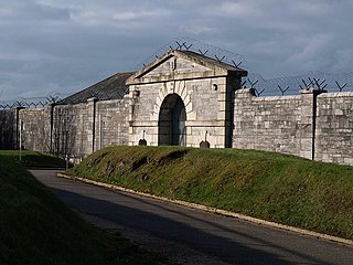
The fortifications of Plymouth in Devon are extensive due to its natural harbour, its commanding position on the Western Approaches and its role as the United Kingdom's second largest naval base after Portsmouth. The first medieval defences were built to defend Sutton Harbour on the eastern side of Plymouth Sound at the mouth of the River Plym, but by the 18th century, naval activity had begun to shift westward to Devonport at the mouth of the River Tamar. During the Victorian era, advances in military technology led to a huge programme of fortification encompassing the whole of Plymouth Sound together with the overland approaches. Many of these works remained in military use well into the 20th century.

The 2nd Devonshire Artillery Volunteers was a unit of the British Volunteer Force and Territorial Army. The unit and its successors defended Plymouth Dockyard and the Devon coast from 1861 to 1961.
| Wikimedia Commons has media related to Devil's Point, Devon . |