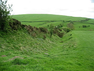
Offa's Dyke is a large linear earthwork that roughly follows the border between England and Wales. The structure is named after Offa, the Anglo-Saxon king of Mercia from AD 757 until 796, who is traditionally believed to have ordered its construction. Although its precise original purpose is debated, it delineated the border between Anglian Mercia and the Welsh kingdom of Powys.

Offa's Dyke Path is a long-distance footpath loosely following the Wales–England border. Officially opened on 10 July 1971, by Lord Hunt, it is one of Britain's National Trails and draws walkers from throughout the world. About 60 miles (97 km) of the 177-mile (285 km) route either follows, or keeps close company with, the remnants of Offa's Dyke, an earthwork traditionally thought to have been constructed in the late 8th century on the orders of King Offa of Mercia.

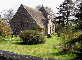
Tintern Abbey was founded on 9 May 1131 by Walter de Clare, Lord of Chepstow. It is situated adjacent to the village of Tintern in Monmouthshire, on the Welsh bank of the River Wye, which at this location forms the border between Monmouthshire in Wales and Gloucestershire in England. It was the first Cistercian foundation in Wales, and only the second in Britain.

Monmouthshire is a county in the south-east of Wales. The name derives from the historic county of the same name; the modern county covers the eastern three-fifths of the historic county. The largest town is Abergavenny, with other towns and large villages being: Caldicot, Chepstow, Monmouth, Magor and Usk. It borders Torfaen, Newport and Blaenau Gwent to the west; Herefordshire and Gloucestershire to the east; and Powys to the north.

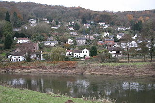
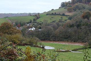
Tintern is a village in the community of Wye Valley, on the west bank of the River Wye in Monmouthshire, Wales, close to the border with England, about 5 miles (8.0 km) north of Chepstow. It is popular with tourists, in particular for the scenery and the ruined Tintern Abbey. Modern Tintern has been formed through the coalescence of two historic villages; Tintern Parva, forming the northern end of the village, and Chapel Hill, which forms the southern end. The village is designated as a Conservation Area.

Tidenham is a village and civil parish in the Forest of Dean of west Gloucestershire, England, adjoining the Welsh border. Tidenham is bounded by the River Wye to the west and the River Severn to the south. Offa's Dyke runs through the western part of the parish, terminating at Sedbury cliff above the River Severn.
Llandogo is a small village in Monmouthshire, south Wales, between Monmouth and Chepstow in the lower reaches of the Wye Valley AONB, two miles north of Tintern. It is set on a steep hillside overlooking the River Wye and across into the Forest of Dean in Gloucestershire, England. The 2011 census population was 547.

The Wye Valley Area of Outstanding Natural Beauty is an internationally important protected landscape straddling the border between England and Wales.

Monnow Valley Walk is a 40 miles (64 km) long-distance footpath in north-east Monmouthshire, South Wales, with short sections in Herefordshire, England and Powys. It links Monmouth and Hay-on-Wye, following the River Monnow and the foot of the Black Mountains. The trail is linear running through the valley of the River Monnow, from Monmouth, near its confluence with the River Wye, to the headwaters below Hay Bluff. At this point, the walk links up with the Offa's Dyke Path National Trail, sharing the same route to the finishing points at Hay-on-Wye.
Whitebrook is a small village in Monmouthshire, south-east Wales, United Kingdom. It is located four miles south east of Monmouth in the Wye Valley.

Trelleck Grange is a small hamlet in a rural area of Monmouthshire, south east Wales, United Kingdom, about seven miles south of Monmouth.

Brockweir is a village in Hewelsfield and Brockweir civil parish, in the Forest of Dean District of Gloucestershire, England. The civil parish also includes the separate village of Hewelsfield.
Hewelsfield is a village in Hewelsfield and Brockweir civil parish, in the Forest of Dean district of Gloucestershire, England.
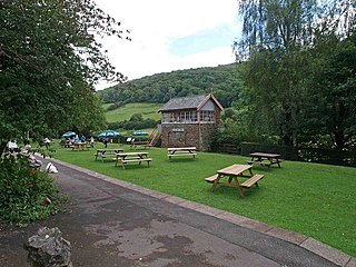
Tintern railway station served the village of Tintern on the Wye Valley Railway. It was opened in 1876 and closed for passengers in 1959 and freight in 1964, when the line was closed completely. It was the second largest station on the line, the most substantial being Monmouth Troy railway station.

The Tintern Wireworks Branch was a short branch line on the Wye Valley Railway, crossing the River Wye between Monmouthshire, Wales, and Gloucestershire, England. It was completed in 1874 and opened on 1 November 1876; the reason for the delay was that the Wye Valley Railway, into which the branch line fed, was not completed until the latter date. It closed in 1935 when the rails buckled in the heat of the summer. The bridge that carried the line over the Wye, known as the Tintern Wireworks Bridge or Old Tramway Bridge, is now used as a footpath, but in 2022 is being temporarily closed for repair.
Redbrook on Wye railway station was a station serving the village of Redbrook on the now disused Wye Valley Railway. It was opened on 1 November 1876 with the rest of the line and remained open for 83 years, it closed in 1959. The sidings and passing loop remained open until late 1961 to serve the Tinplate Works in the village.

Tintern Quarry was a quarry in the Forest of Dean, Gloucestershire, England. It was served by the Wye Valley Railway from 1876 until it closed in 1981. The quarry was on the opposite side of the River Wye from the village of Tintern.

Lippets Grove is a 5-hectare (12-acre) nature reserve in Gloucestershire. The site was leased from the Forestry Commission in 1987 and is managed by the Gloucestershire Wildlife Trust. The site is listed in the 'Forest of Dean Local Plan Review' as a Key Wildlife Site (KWS).

East Wood and is a 0.82-hectare (2.0-acre) nature reserve in Gloucestershire, England. The west site is 0.45-hectare (1.1-acre). The east site is 0.37-hectare (0.91-acre). It is part of a larger area of woodland called East Wood, which is adjacent to Oakhill Wood and Woolaston Wood (east). The site was leased from the Forestry Commission in 1986 and is managed by the Gloucestershire Wildlife Trust. The site is listed in the 'Forest of Dean Local Plan Review' as a Key Wildlife Site (KWS).
Ridley Bottom is a 1.1-hectare (2.7-acre) nature reserve in Gloucestershire. The site is listed in the 'Forest of Dean Local Plan Review' as a Key Wildlife Site (KWS).


