
Sex-selective abortion is the practice of terminating a pregnancy based upon the predicted sex of the infant. The selective abortion of female fetuses is most common where male children are valued over female children, especially in parts of East Asia and South Asia, as well as in the Caucasus, Western Balkans, and to a lesser extent North America. Based on the third National Family and Health Survey, results showed that if both partners, mother and father, or just the father, preferred male children, sex-selective abortion was more common. In cases where only the mother prefers sons, this is likely to result in sex-selective neglect in which the child is not likely to survive past infancy.
Kamuthi also spelled Kamudi actually stands for Kavinmigu Mullai Thirunagar. Kamuthi is a Panchayat town in Ramanathapuram district in the Indian state of Tamil Nadu.
Kheta Sarai is a town and a nagar panchayat in Jaunpur district of the Indian state of Uttar Pradesh.
Vijalpor is a city and a municipality in Navsari district in the Indian state of Gujarat. The city is under Surat Metropolitan Region. The town is located at a distance of 7 km south of Navsari City off Udhana-Nasik Highway.
Chirakkal is a census town in Kannur district in the state of Kerala, India. It is a suburb of Kannur city of about 7 km away.
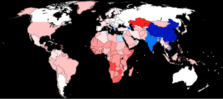
The human sex ratio is the ratio of males to females in a population in the context of anthropology and demography. In humans, the natural sex ratio at birth is slightly biased towards the male sex. It is estimated to be about 1.05 or 1.06 or within a narrow range from 1.03 to 1.06 males per female.
Eyyal is a village in Thrissur District in the state of Kerala, India. Archeologists have unearthed a collection of old Roman coins in 1946. These coins date from 123 BC to 117 AD. These coins currently exhibited in the Archeological Museum of Thrissur.
The child sex ratio in India is defined as the number of females per thousand males in the age group 0–6 years in a human population. Thus it is equal to 1000 x the reciprocal of the sex ratio in the same age group, i.e. under age seven. An imbalance in this age group will extend to older age groups in future years. Currently, the ratio of males to females is generally significantly greater than 1, i.e. there are more boys than girls.
Hejamadi or Hejamady is a village in the southern state of Karnataka, India.It is located on north banks of river Shambhavi, while Mulky is located on southern banks. There is an old road diverting from NH-66 leading to village. It is located in the Udupi taluk of Udupi district and 28 km north of Mangalore in Karnataka. Areas in Hejamady: Guddeyangadi, Shiv Nagar, Kannangar, Hejamady, Mattu Patna, Aache Mattu, Doddagundi, Sannagundi, Palimar, Kodi, Gundi, North Sultan Road, South Sultan Road, Maruthi Road and AmavaseKariya.
Katamalli is a village in Belgaum district in Karnataka, India.
Kutaranatti is a village in Belgaum district in Karnataka, India.

Khed taluka is a taluka in the subdivision, near Pune city in Pune district of the state of Maharashtra in India. Rajgurunagar is the headquarter of the taluka. The taluka is known for being the birthplace of Santaji Jagnade.The name of city is rajgurunagar on the name of Shaheed Shivram Hari Rajguru.
Kerur is a town in Bagalkot district in Karnataka, which located on NH 218. It has an average elevation of 617 meters (2024 feet). It's the birthplace of Jagadish Shettar, a former Chief Minister of Karnataka. Kerur is a Town Panchayat city in the district of Bagalkot, Karnataka. The Kerur city is divided into 16 wards for which elections are held every five years. The Kerur Town Panchayat has a population of 19,731 of which 9,929 are males while 9,802 are females as per report released by Census India 2011.
Faizabad Junction railway station, officially known as Ayodhya Cantt railway station, is a railway station in Uttar Pradesh, India. It is located on the Lucknow-Varanasi section and is a part of the Northern Railway zone. Faizabad Junction and Ayodhya Junction are the two railway junction stations in Ayodhya district.
Female foeticide in India is the abortion of a female foetus outside of legal methods. A research by Pew Research Center based on Union government data indicates foeticide of at least 9 million females in the years 2000–2019. The research found that 86.7% of these foeticides were by Hindus, followed by Sikhs with 4.9%, and Muslims with 6.6%. The research also indicated an overall decline in preference for sons in the time period.
Rajivnagar is a large village located in Zawlnuam of Mamit district, Mizoram with total 708 families residing. The Rajivnagar village has population of 3530 of which 1796 are males while 1734 are females as per Population Census 2011. Rajiv nagar also known as Aamsury is an important business center for local Chakma people.
Puduvoyal is a village panchayat located in the Thiruvallur district of Indian state of Tamil Nadu.
Chak Sahbu is a small village in Jalandhar District of Punjab State, India. The village is administrated by Sarpanch who is elected representative of village. It is located 49 km towards East from Jalandhar, 14 km from Phillaur and 119 km from Chandigarh. The nearest census town and marketplace is located 1 km in Apra, Punjab. The nearest train station is situated 13.9 km away in Phillaur, nearest domestic airport is at Ludhiana and the nearest international airport is 143 km away in Amritsar.


