
Roydon is a village located in the Epping Forest district of the county of Essex, England. It is located 2 miles (3.2 km) west of Harlow, 4 miles (6.4 km) east of Hoddesdon and 5 miles (8.0 km) northwest of Epping, forming part of the border with Hertfordshire.

Albert is a provincial electoral district for the Legislative Assembly of New Brunswick, Canada. It was created in 1973 when New Brunswick moved to single member districts and the former multi-member riding of Albert was split into this riding and the new riding of Riverview.
Shortepa also Shor Tappeh is one of the 15 districts of Balkh province. Shortepa, a small district in Balkh Province, Afghanistan. It is situated along the Amu Darya river, across the border with Termez, Uzbekistan, and to the east Kaldar. The main village is Shor Tappeh, A at 274 m altitude.

Dharbandora is a taluka of Goa state, India, with an estimated population of 30,000 to 40,000.
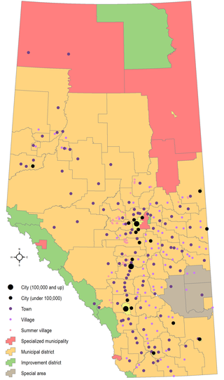
Municipal elections were held in Alberta, Canada on Monday, October 21, 2013. Mayors (reeves), councillors (aldermen), and trustees were elected to office in 16 of the 17 cities, all 108 towns, all 93 villages, all 5 specialized municipalities, all 64 municipal districts, 3 of the 8 improvement districts, and the advisory councils of the 3 special areas. The City of Lloydminster is on the Saskatchewan schedule (quadrennial), and held elections on October 24, 2012, while 5 improvement districts have no councils and are led solely by the Minister of Municipal Affairs. Since the 2010 municipal elections, portions of Lac La Biche County and the Regional Municipality of Wood Buffalo formed Improvement District No. 349, and the villages of New Norway and Tilley were dissolved. From 1968 to 2013, provincial legislation has required every municipality to hold elections every three years. The Alberta Legislative Assembly passed a bill on December 5, 2012, amending the Local Authorities Election Act. Starting with the 2013 elections, officials are elected for a four-year term, and municipal elections are moved to a four-year cycle.
Sameliya is a patwar circle and village in ILRC Nimera in Phagi Tehsil in Jaipur district, Rajasthan. Sameliya is also a patwar circle for nearby villages, Chandama Khurd and Mandap.
Himatnagar is one of the 182 Legislative Assembly constituencies of Gujarat state in India. It is part of Sabarkantha district. It is numbered as 27-Himatnagar.
Vejalpur is one of the 182 Legislative Assembly constituencies of Gujarat state in India. It is part of Ahmedabad district and it came into existence after 2008 delimitation.
Jasdan is one of the 183 Legislative Assembly constituencies of Gujarat state in India. It is part of Rajkot district.
Jamjodhpur is one of the 182 Legislative Assembly constituencies of Gujarat state in India. It is part of Jamnagar district.
Bhavnagar Rural is one of the 182 Legislative Assembly constituencies of Gujarat state in India. It is part of Bhavnagar district. The current Member of the Legislative Assembly is Parshottam Solanki of the Bharatiya Janata Party (BJP).
Bhavnagar East is one of the 182 Legislative Assembly constituencies of Gujarat state in India. It is part of Bhavnagar district.
Bhavnagar West is one of the 182 Legislative Assembly constituencies of Gujarat state in India. It is part of Bhavnagar district.
Borsad is one of the 182 Legislative Assembly constituencies of Gujarat state in India.
Ismailpur (Harauli) is a village in Vaishali district of Bihar state in India.
Petlad is one of the 182 Legislative Assembly constituencies of Gujarat state in India. It is part of Anand district.
Morva Hadaf is one of the 182 Legislative Assembly constituencies of Gujarat state in India. It is part of Panchmahal district and is reserved for candidates belonging to the Scheduled Tribes. The seat was formed after the delimitation exercise of 2008 and is a part of Panchmahal Lok Sabha constituency.
Karjan is one of the 182 Legislative Assembly constituencies of Gujarat state in India. It is part of Vadodara district.

Meenangadi is an old town situated on the highway NH 766 between Kalpetta and Sulthan Bathery in Wayanad District, in Kerala, India. This place is one among the Provinces where the existence of Dolmens provide an historical evidence of earlier civilisation. Coffee bean, Black pepper, Ginger, Rice and Areca are the major crops cultivated in this area. Meenangadi is famous for its Fish Market and Cattle Market. The nearest railway station is at Kozhikode at 87 km and airport is Kannur International Airport with 94 km from Meenangadi. Meenangadi is surrounded by, Ambalavayal Panchayat, Kalpetta Taluk towards west, Gudalur Taluk towards East, Mananthavady Taluk towards west. Kalpetta, Sultan Bathery, Kozhikode are the nearby Cities and towns to Meenangadi.
Kerala's first carbon neutrality project launched in Meenangadi in June 2016. Upon achieving the goals of the project, Meenangadi will be the first village in India to go completely carbon neutral. Meenangadi has a population of 33450 According to 2011 Census with two Villages Purakkadi and (Part)Krishnagiri.

