This article does not cite any sources .(August 2015) (Learn how and when to remove this template message) |
Dhrang or Dhrung is a small village located in Kutch District of Gujarat State of India. The village is on border to Pakistan. The other known village nearby is Lodai.

Gujarat is a state on the western coast of India with a coastline of 1,600 km (990 mi) – most of which lies on the Kathiawar peninsula – and a population in excess of 60 million. It is the sixth largest Indian state by area and the ninth largest state by population. Gujarat is bordered by Rajasthan to the northeast, Daman and Diu to the south, Dadra and Nagar Haveli and Maharashtra to the southeast, Madhya Pradesh to the east, and the Arabian Sea and the Pakistani province of Sindh to the west. Its capital city is Gandhinagar, while its largest city is Ahmedabad. The Gujarati-speaking people of India are indigenous to the state. The economy of Gujarat is the third-largest state economy in India with ₹14.96 lakh crore (US$210 billion) in gross domestic product and a per capita GDP of ₹157,000 (US$2,200).

India, also known as the Republic of India, is a country in South Asia. It is the seventh largest country by area and with more than 1.3 billion people, it is the second most populous country as well as the most populous democracy in the world. Bounded by the Indian Ocean on the south, the Arabian Sea on the southwest, and the Bay of Bengal on the southeast, it shares land borders with Pakistan to the west; China, Nepal, and Bhutan to the northeast; and Bangladesh and Myanmar to the east. In the Indian Ocean, India is in the vicinity of Sri Lanka and the Maldives, while its Andaman and Nicobar Islands share a maritime border with Thailand and Indonesia.

Pakistan, officially the Islamic Republic of Pakistan, is a country in South Asia. It is the world’s sixth-most populous country with a population exceeding 212,742,631 people. In area, it is the 33rd-largest country, spanning 881,913 square kilometres. Pakistan has a 1,046-kilometre (650-mile) coastline along the Arabian Sea and Gulf of Oman in the south and is bordered by India to the east, Afghanistan to the west, Iran to the southwest, and China in the far northeast. It is separated narrowly from Tajikistan by Afghanistan's Wakhan Corridor in the northwest, and also shares a maritime border with Oman.
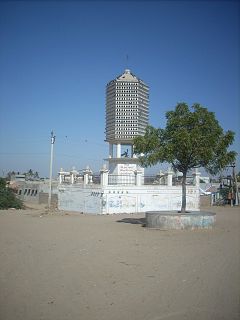
The village is known and famous for Samadhi of Sant Mekan Dada and his five disciples and his animal friends Laliyo, the donkey and Motiyo, the dog. A fair is held in memory of Mekan Dada every year in Hindu calendar month of Magh (February–March), which ends on day of Mahashivratri. The fair being traditionally held over the centuries, is now promoted by Government of Gujarat.

Samādhi, also called samāpatti, in Buddhism, Hinduism, Jainism, Sikhism and yogic schools refers to a state of meditative consciousness. In the Yogic traditions, and the Buddhist commentarial tradition on which the Burmese Vipassana movement and the Thai Forest tradition rely, it is a meditative absorption or trance, attained by the practice of dhyāna. In the oldest Buddhist suttas, on which several contemporary western Theravada teachers rely, it refers to the development of a luminous mind which is equanimous and mindful.
Sant Mekan Dada or Mekan baba was a Sufi saint from Kutch, Gujarat, India.
Hindu calendar is a collective term for the various lunisolar calendars traditionally used in the Indian subcontinent. They adopt a similar underlying concept for timekeeping, but differ in their relative emphasis to moon cycle or the sun cycle and the names of months and when they consider the New Year to start. Of the various regional calendars, the most studied and known Hindu calendars are the Shalivahana Shaka found in South India, Vikram Samvat (Bikrami) found in North and Central regions of India, Tamil calendar used in Tamil Nadu, and the Bengali calendar used in the Bengal – all of which emphasize the lunar cycle. Their new year starts in spring, with their heritage dating back to 1st millennium BCE. In contrast, in regions such as Kerala, the solar cycle is emphasized and this is called the Malayalam calendar, their new year starts in autumn, and these have origins in the second half of the 1st millennium CE. A Hindu calendar is sometimes referred to as Panchanga (पञ्चाङ्ग).
The temple and Samadhi of Mekan Dada is visited by people from all over Gujarat as well Rajasthan at time of this fair. Among the major follower of Mekan Dada are Ahir, who consider him as their God. The Kapadi community, to whom the Sant Mekan Dada belonged are major disciples and also manage the temple premises and Akhara, also known as Mekan Dada no Akharo. Mistri and Rabari also are his followers. The temple was built by architects belonging to Mistri community, under patronage of King of Kutch. Rao Deshalji II of Kutch was also a follower of Mekan Dada. The samadhi of one Mistri Kanji, who was among the first five disciples of Sant Mekan Dada, is also within this premises.

Rajasthan is a state in northern India. The state covers an area of 342,239 square kilometres (132,139 sq mi) or 10.4 percent of the total geographical area of India. It is the largest Indian state by area and the seventh largest by population. Rajasthan is located on the northwestern side of India, where it comprises most of the wide and inhospitable Thar Desert and shares a border with the Pakistani provinces of Punjab to the northwest and Sindh to the west, along the Sutlej-Indus river valley. Elsewhere it is bordered by five other Indian states: Punjab to the north; Haryana and Uttar Pradesh to the northeast; Madhya Pradesh to the southeast; and Gujarat to the southwest.
Ahir or Aheer is an ethnic group, some members of which identify as being of the Indian Yadav community because they consider the two terms to be synonymous. The Ahirs are variously described as a caste, a clan, a community, a race and a tribe.
Kapadi is one of the minority Hindu community of India, who are followers of Kapadi Sampradaya.


