Related Research Articles

The Amu Darya, also called the Amu, the Amo, and historically the Oxus, is a major river in Central Asia, which flows through Tajikistan, Turkmenistan, Uzbekistan and Afghanistan. Rising in the Pamir Mountains, north of the Hindu Kush, the Amu Darya is formed by the confluence of the Vakhsh and Panj rivers, in the Tigrovaya Balka Nature Reserve on the border between Afghanistan and Tajikistan, and flows from there north-westwards into the southern remnants of the Aral Sea. In its upper course, the river forms part of Afghanistan's northern border with Tajikistan, Uzbekistan, and Turkmenistan. In ancient history, the river was regarded as the boundary of Greater Iran with Turan, which roughly corresponded to present-day Central Asia. The Amu Darya has a flow of about 70 cubic kilometres per year on average.
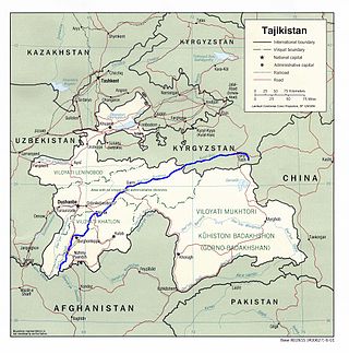
Tajikistan is nestled between Kyrgyzstan and Uzbekistan to the north and west, China to the east, and Afghanistan to the south. Mountains cover 93 percent of Tajikistan's surface area. The two principal ranges, the Pamir Mountains and the Alay Mountains, give rise to many glacier-fed streams and rivers, which have been used to irrigate farmlands since ancient times. Central Asia's other major mountain range, the Tian Shan, skirts northern Tajikistan. Mountainous terrain separates Tajikistan's two population centers, which are in the lowlands of the southern and northern sections of the country. Especially in areas of intensive agricultural and industrial activity, the Soviet Union's natural resource utilization policies left independent Tajikistan with a legacy of environmental problems.

The Karakoram is a mountain range in the Kashmir region spanning the border of Pakistan, China, and India, with the northwestern extremity of the range extending to Afghanistan and Tajikistan. Most of the Karakoram mountain range falls under the jurisdiction of Gilgit-Baltistan, which is controlled by Pakistan. Its highest peak, K2, is located in Gilgit-Baltistan, Pakistan. It begins in the Wakhan Corridor (Afghanistan) in the west, encompasses the majority of Gilgit-Baltistan, Pakistan and extends into Ladakh and Aksai Chin. It is part of the larger Trans-Himalayan mountain ranges.
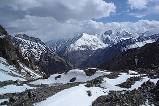
The Pamir Mountains are a range of mountains between Central Asia and South Asia. They are located at a junction with other notable mountains, namely the Tian Shan, Karakoram, Kunlun, Hindu Kush and the Himalaya mountain ranges. They are among the world's highest mountains.
The Zarafshon is a river in Tajikistan and Uzbekistan in Central Asia. Its name, "spreader of gold" in Persian, refers to the presence of gold-bearing sands in the upper reaches of the river. To the ancient Greeks it was known as the Polytimetus. It was also formerly known as Sughd River. The river is 877 kilometres (545 mi) long and has a basin area of 17,700 square kilometres (6,800 sq mi).
The Vakhsh, also known as the Surkhob, in north-central Tajikistan, and the Kyzyl-Suu, in Kyrgyzstan, is a Central Asian river, and one of the main rivers of Tajikistan. It is a tributary of the Amu Darya river.
The Yazghulom is a river in Vanj district, western Gorno-Badakhshan, Tajikistan. It is a right tributary of the Panj. The river is 80 kilometres (50 mi) long and has a basin area of 1,970 square kilometres (760 sq mi).

The Vanj is a river in east Tajikistan. It is a right tributary of the Panj in Vanj District, north-western Gorno-Badakhshan. The river is 103 kilometres (64 mi) long and has a basin area of 2,070 square kilometres (800 sq mi). It flows southwest between the Darvoz Range to the north and the Vanj Range to the south, joining the Panj on the border with Afghanistan. The Vanj valley is broader and more fertile than other valleys feeding the Panj. Vanj town is about 20 km upstream from the Panj. At the head of the valley, beyond the village of Po-i-Mazar, the river turns southeast and is fed by the Geographical Society Glacier near Independence Peak. Beyond the head of the valley are the Academy of Sciences Range and the Fedchenko Glacier.

The Vanch-Yakh Glacier is a large glacier in the Yazgulem Range, Pamir Mountains, of north-central Gorno-Badakhshan province, Tajikistan. The glacier is long and narrow, currently extending for 77 kilometres (48 mi) and covering over 700 square kilometres (270 sq mi). It is the longest glacier in the world outside of the polar regions. The maximum thickness of the glacier is 1,000 metres (3,300 ft), and the volume of the glacier and its dozens of tributaries is estimated at 144 cubic kilometres (35 cu mi)—about a third of the volume of Lake Erie.
Peak Ozodi, is the third highest peak in the Pamir Mountains of Tajikistan. It is one of the five "Snow Leopard Peaks" in the territory of the former Soviet Union. It is named after Evgenia Korzhenevskaya, the wife of Russian geographer Nikolai L. Korzhenevskiy, who discovered the peak in August 1910.

The retreat of glaciers since 1850 is well documented and is one of the effects of climate change. The retreat of mountain glaciers provide evidence for the rise in global temperatures since the late 19th century. Examples include mountain glaciers in western North America, Asia, the Alps in central Europe and tropical and subtropical regions of South America and Africa. Since glacial mass is affected by long-term climatic changes, e.g., precipitation, mean temperature, and cloud cover, glacial mass changes are one of the most sensitive indicators of climate change. Retreat of glaciers is also a major reason for sea level rise. Excluding peripheral glaciers of ice sheets, the total cumulated global glacial losses over the 26-year period from 1993 to 2018 were likely 5500 gigatons, or 210 gigatons per yr.
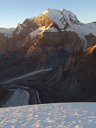
Independence Peak or Qullai Istiqlol, at 6,940 m (22,769 ft), is the seventh-highest peak in the Pamir Mountains, located at the center of Tajikistan's Gorno-Badakhshan Autonomous Province, above the source of the Yazgulem River in the Yazgulem Range. The mountain consists of three snow- and ice-covered summits and its northwest face is the source of the Fedchenko Glacier.

Murghob District is a district in Tajikistan, occupying the eastern two-thirds of the Gorno-Badakhshan Autonomous Region (GBAO). The area of Murghob District is 37,300 km2, covering 26 percent of Tajikistan's soil, but only 0.17% of its population. Murghob District borders on Kyrgyzstan to the north, China to the east, and Afghanistan to the south. The population of Murghob District is 15,900. Its administrative capital is the village Murghob.

Tursunzoda District is the westernmost district of the Districts of Republican Subordination (RRP), bordering on Uzbekistan in the west and enclosed by Tajikistan's Shahrinav District from the other directions. Its capital is Tursunzoda, called Regar, or "a town on sand", until 1978. Thanks to its warm weather and plentiful irrigation from the local rivers, Tursunzoda District is a major grower of rice and cotton in Tajikistan. In 2006 it produced 1,400 tons of rice and 7,300 tons of cotton. It ranks first in the production of these commodities among the districts in RRP. Around 2018, the district was merged into the city of Tursunzoda.
Yazgulem Range is a mountain range of the western Pamir Mountains.
The Sarikol Range is a mountain range in the Pamirs on the border of Tajikistan and the People's Republic of China.
The Karatag or Qaratogh, Qaratoghdaryo is a river of northwestern Tajikistan and eastern Uzbekistan. It flows through Shirkent National Park and flows down the south slopes of the Hisar mountain range. At its confluence with the Toʻpolondaryo, the Surxondaryo is formed. The river is 112 kilometres (70 mi) long. Large seismic landslides occur in the river basin and it also contains several glacial lakes. Upstream from the confluence with the Payron, the Karatag is called Diakhandara. Another tributary is the Zambar. The Diakhandara Glacier, which fed the upper course of the Karatag, has fully melted.
The Zambar is a river of the Gissar Range in northern Tajikistan. It is a left tributary of the Karatag. In the upper valley of the river, 2800–3200 metres, there are range of kars and glacial lakes. The mountainside of the valley is said to be "concave with wide bottom and four visible ancient mountain ridges" and the Zambar valley "converges to V-form below with a longitudinal slope greatly rising". The river course is turbulent, with numerous rocky ledges and waterfalls.

The Isfara is a river of the Syr Darya basin in Kyrgyzstan, Tajikistan and Uzbekistan. In its upper course, it is called Ak-Suu, in its middle course Karavshin.
Shughnon Range or Shugnan Range is a mountain range in Tajikistan, part of the Pamir Mountain System. Administratively it is located in Tajikistan's Region of Republican Subordination.
References
- ↑ "Field research of glaciers and glacial lakes located in Karatag, Vakhsh and Zeravshan river basin" (PDF). Meteo. Retrieved 13 May 2012.[ permanent dead link ]
- ↑ "Third National Communication of the Republic of Tajikistan under the United Nations Framework Convention on Climate Change" (PDF). 2014. p. 75.
| | This Tajikistan location article is a stub. You can help Wikipedia by expanding it. |
| | This article about a glacier is a stub. You can help Wikipedia by expanding it. |