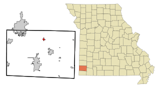
Diamond is a city in north central Newton County, Missouri, United States, located southeast of Joplin. The population was 902 at the 2010 census. It is part of the Joplin, Missouri, Metropolitan Statistical Area. Diamond is primarily renowned as the birthplace of George Washington Carver.

Theodore Roosevelt National Park is an American national park of the badlands in western North Dakota comprising three geographically separated areas. Honoring U.S. President Theodore Roosevelt, it is the only American national park named directly after a single person.

The tallgrass prairie is an ecosystem native to central North America. Historically, natural and anthropogenic fire, as well as grazing by large mammals provided periodic disturbances to these ecosystems, limiting the encroachment of trees, recycling soil nutrients, and facilitating seed dispersal and germination. Prior to widespread use of the steel plow, which enabled large scale conversion to agricultural land use, tallgrass prairies extended throughout the American Midwest and smaller portions of southern central Canada, from the transitional ecotones out of eastern North American forests, west to a climatic threshold based on precipitation and soils, to the southern reaches of the Flint Hills in Oklahoma, to a transition into forest in Manitoba.

George Washington Carver National Monument is a unit of the National Park Service in Newton County, Missouri. The national monument was founded on July 14, 1943, by Franklin Delano Roosevelt, who dedicated $30,000 to the monument. It was the first national monument dedicated to an African American and first to a non-president.
The Charles M. Russell National Wildlife Refuge is a National Wildlife Refuge in the U.S. state of Montana on the Missouri River. The refuge surrounds Fort Peck Reservoir and is 915,814 acres (3,706.17 km2) in size. It is the second-largest National Wildlife Refuge in the lower 48 states of the United States, and the largest in Montana. Created in 1936, it was originally called the Fort Peck Game Range. It was renamed in 1963 after Montana artist Charles M. Russell, a famous painter of the American West. In 1976, the "range" was made a "refuge".

Des Plaines Fish and Wildlife Area is an Illinois state park on 5,000 acres (2,023 ha) in Will County, Illinois, United States. It is located on floodplain adjacent to the confluence of the Des Plaines River and the Kankakee River to form the Illinois River.
Difficult Creek Natural Area Preserve is an 819-acre (3.31 km2) Natural Area Preserve located in Halifax County, Virginia. The preserve aims to restore a portion of Virginia's southern Piedmont to pre-settlement conditions, when the region was dominated by savannas maintained through a natural fire regime. These savannas featured open, prairie-like areas with scattered pines and hardwoods. Management of the preserve includes utilizing prescribed burns and removing loblolly pine plantations to restore the former landscape. Several rare plants, remnants of the original prairie vegetation, survived by colonizing roadsides and power lines; these plants are now protected and encouraged within the preserve.
Pershing State Park is a public recreation area covering more than 5,000 acres (2,000 ha) off U.S. Route 36, three miles west of Laclede in Linn County, Missouri. The state park was named in honor of General of the Armies John J. Pershing, who led the United States forces in Europe in World War I and who grew up in Laclede.
Howell Island Conservation Area protected area covering 2,547 acres (10.31 km2) and managed by the Missouri Department of Conservation on Howell Island located in the Missouri River in Boone Township, St. Charles County, Missouri, although the MDOC land surrounding the parking area is in St. Louis County. The island is bounded by the Missouri River on the north side and Centaur Chute to the south. The island is mostly forested in bottomland trees such as sycamore and cottonwood.

American Prairie is a prairie-based nature reserve in Central Montana being developed as a private project of the American Prairie Foundation (APF). This independent non-profit organization is creating a wildlife conservation area that aims to cover over 3 million acres (12,000 km2) through a combination of both private and public lands to restore a mixed grass prairie ecosystem with migration corridors and native wildlife.

Cayler Prairie State Preserve is a 160-acre land parcel of tallgrass prairie located in the northwest region of the U.S. state of Iowa in Dickinson County near Spirit Lake. It is a National Natural Landmark.

Pilot Grove State Preserve is a historic site located southwest of Williamsburg, Iowa, United States in rural Iowa County. The site is a wooded knoll surrounded by prairie between the North English River and Old Man's Creek. It consists of hickory, oak and walnut trees, along with patches of virgin prairie covered with bluestem, gramma, switch and Indian grasses, and a variety of native prairie wildflowers. There was no other timber in the area during the early years of Iowa's settlement, and it was a landmark for the pioneers traveling west across the state. It was given its name because it gave people who traveled to and from Marengo, Iowa a sense of direction. A 4-acre (1.6 ha) cemetery was established adjacent to the knoll in 1867. The site was listed on the National Register of Historic Places in 1977. The property had been owned by the Kelting family, who donated it to the Iowa Conservation Commission so that they could restore it and maintain its mid-19th-century condition at the time of Iowa's pioneer settlement. It was dedicated as a historical state preserve in 1980.

Virginia Wildlife Management Areas (WMAs) are state-managed protected areas that exist primarily for the benefit of wildlife. Within the Commonwealth of Virginia, 46 tracts of land have been protected as WMAs, covering a total of over 216,000 acres. They are managed and maintained by the Virginia Department of Wildlife Resources.
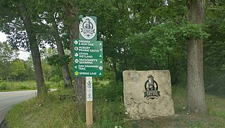
The Hobart Nature District is located in the City of Hobart, Indiana and includes over 1,000 acres (400 ha) of scenic parks, wetlands and floodplains, winding rivers, peaceful lakes, open prairies, oak savannas, old-growth forests, and undulating ravines.

Charles E. Wheeler Wildlife Management Area is a 625-acre (253 ha) brackish tidal marsh, nature preserve and hunting area owned by the state of Connecticut located in Devon (village), Milford, New Haven County, Connecticut.
The Missouri Prairie Foundation (MPF) is a private-sector nonprofit foundation dedicated to the stewardship of original and replanted tallgrass prairie lands in the U.S. state of Missouri. Missouri, together with its neighbor state Iowa, are at the heart of the tallgrass prairie biome. In large stretches of interior North America, local climate patterns favor well-watered grassland or grassy savanna, and MPF celebrates this pattern of local natural areas. As of 2023, the MPF owns more than 4,400 acres of prairie in 32 tracts in various locations throughout Missouri.
The Taberville Prairie Conservation Area is a 1,680-acre (685-hectare) unit, including a 1,360-acre tallgrass prairie which is a natural area located in St. Clair County in the U.S. state of Missouri. The conservation area is characterized by rolling tallgrass prairie, with outcrops of sandstone. The Taberville Prairie, located within the conservation area, is a National Natural Landmark.
Cupola Pond is a karstland sinkhole location within Ripley County in the U.S. state of Missouri. The site is a National Natural Landmark. Located within Mark Twain National Forest, the pond site and sinkhole are protected by the United States Forest Service.
The Maple Woods Natural Area is a natural area located in Clay County in the U.S. state of Missouri. The natural area is characterized by sugar maples. The 39.3-acre forest is recognized by the United States National Park Service as a Significant Natural Area. The small forest is a National Natural Landmark.

