Diamond Island (Kentucky)

Last updated
Diamond Island
Geography
Location Ohio River, Henderson County, Kentucky, United States
Coordinates 37°54′N87°48′W / 37.9°N 87.8°W / 37.9; -87.8
Area0.5 sq mi (1.3 km2)
Highest elevation360 ft (110 m)
Administration
United States
State Kentucky
County Henderson
Population(0)
Location of Diamond Island is in Henderson County, Kentucky Map of Kentucky highlighting Henderson County.svg
Location of Diamond Island is in Henderson County, Kentucky
River pirates at Diamond Island preyed on the Ohio River flatboats, keelboats, and rafts, as profitable targets of goods, attacking the crews and pioneers who were easily overwhelmed and killed. Keelboat and flatboat.jpg
River pirates at Diamond Island preyed on the Ohio River flatboats, keelboats, and rafts, as profitable targets of goods, attacking the crews and pioneers who were easily overwhelmed and killed.

Diamond Island is an island in the Ohio River ten miles west of Henderson in Henderson County, Kentucky, United States. It has an area of about half a square mile.

Ohio River river in the midwestern United States

The Ohio River is a 981-mile (1,579 km) long river in the midwestern United States that flows southwesterly from western Pennsylvania south of Lake Erie to its mouth on the Mississippi River at the southern tip of Illinois. It is the second largest river by discharge volume in the United States and the largest tributary by volume of the north-south flowing Mississippi River that divides the eastern from western United States. The river flows through or along the border of six states, and its drainage basin includes parts of 15 states. Through its largest tributary, the Tennessee River, the basin includes several states of the southeastern U.S. It is the source of drinking water for three million people.

Henderson, Kentucky City in Kentucky, United States

Henderson is a home rule-class city along the Ohio River in Henderson County in western Kentucky in the United States. The population was 28,757 at the 2010 U.S. census. It is part of the Evansville Metropolitan Area, locally known as the "Kentuckiana" or the "Tri-State Area".

Henderson County, Kentucky County in the United States

Henderson County is a county located in the U.S. state of Kentucky. As of the 2010 census, the population was 46,250. The county seat is Henderson. The county was formed in 1798 and named for Colonel Richard Henderson who purchased 17,000,000 acres (69,000 km2) of land from the Cherokee Indians, part of which would eventually make up the county.

Contents

History

River piracy

In the late eighteenth century, it was a hideout for river pirates, most notably Samuel Mason and his gang in 1797 and the serial killers, the Harpe Brothers.

Piracy Act of robbery or criminal violence at sea

Piracy is an act of robbery or criminal violence by ship or boat-borne attackers upon another ship or a coastal area, typically with the goal of stealing cargo and other valuable items or properties. Those who engage in acts of piracy are called pirates. The earliest documented instances of piracy were in the 14th century BC, when the Sea Peoples, a group of ocean raiders, attacked the ships of the Aegean and Mediterranean civilizations. Narrow channels which funnel shipping into predictable routes have long created opportunities for piracy, as well as for privateering and commerce raiding. Historic examples include the waters of Gibraltar, the Strait of Malacca, Madagascar, the Gulf of Aden, and the English Channel, whose geographic structures facilitated pirate attacks. A land-based parallel is the ambushing of travelers by bandits and brigands in highways and mountain passes. Privateering uses similar methods to piracy, but the captain acts under orders of the state authorizing the capture of merchant ships belonging to an enemy nation, making it a legitimate form of war-like activity by non-state actors.

Samuel Mason American judge

Samuel Ross Mason also, spelled Meason was a Virginia militia captain, on the American western frontier, during the American Revolutionary War. After the war, he became the leader of the Mason Gang, a criminal gang of river pirates and highwaymen on the lower Ohio River and the Mississippi River in the late 18th and early 19th centuries. He was associated with outlaws around Red Banks, Cave-in-Rock, Stack Island, and the Natchez Trace.

Diamond Island Massacre

In 1803, the Barnard family was emigrating from Virginia when one son, James, shot a deer on the bank. The family landed the boat to retrieve the deer and were ambushed by ten Native Americans, who were hiding in the canebrake. The first to board the boat was killed by Mrs. Barnard with an axe. Mr. Barnard shot and killed two before he was killed. The son, James, ran away with a corn knife, pursued by two. When one fell behind, James turned to fight and the last pursuer fled.

Canebrake

A canebrake or canebreak is a thicket of any of a variety of Arundinaria grasses: A. gigantea, A. tecta and A. appalachiana. As a bamboo, these giant grasses grow in thickets up to 24 ft tall. A. gigantea is generally found in stream valleys and ravines throughout the southeastern US. A. tecta is a smaller stature species found on the Atlantic and Gulf Coastal Plains. Finally, A. appalachiana is found in more upland areas at the southern end of the Appalachian mountains.

When James returned to the boat, his mother and father lay dead, and his two younger brothers and one sister were missing. What became of the three children was never known. [1]

Related Research Articles

Henderson County, Tennessee County in the United States

Henderson County is a county located in the U.S. state of Tennessee. As of the 2010 census, the population was 27,769. Its county seat is Lexington. The county was founded in 1821 and named for James Henderson, a soldier in the War of 1812.

Chokoloskee, Florida Census-designated place in Florida

Chokoloskee is an unincorporated community and census-designated place (CDP) located at the edge of the Ten Thousand Islands in Collier County, Florida, United States. The population was 359 at the 2010 census. It is part of the Naples–Marco Island Metropolitan Statistical Area.

Doddsville, Mississippi Town in Mississippi, United States

Doddsville is a town in Sunflower County, Mississippi. The population was 98 at the 2010 census. It was established by Daniel Doddsman Sr. in 1889.

Columbia, Tennessee City in Tennessee, United States

Columbia is a city in and the county seat of Maury County, Tennessee, United States. The population was 34,681 at the 2010 census and in 2013 the population was 35,558.

Columbia, Virginia Unincorporated community in Virginia, United States

Columbia, formerly known as Point of Fork, is an unincorporated community in Fluvanna County, Virginia, United States, at the confluence of the James and Rivanna rivers. Following a referendum, Columbia was dissolved as an incorporated town – until that time the smallest in Virginia – on July 1, 2016. As of the 2010 census, the town's population was 83, up from 49 at the 2000 census.

Key Biscayne island in the United States of America

Key Biscayne is an island located in Miami-Dade County, Florida, United States, between the Atlantic Ocean and Biscayne Bay. It is the southernmost of the barrier islands along the Atlantic coast of Florida, and lies south of Miami Beach and southeast of Miami. The key is connected to Miami via the Rickenbacker Causeway, originally built in 1947.

Government Island (Oregon)

Government Island is a 1,760-acre (710 ha) island in the Columbia River north of Portland, in Multnomah County, in the U.S. state of Oregon. Though Interstate 205 passes over it on the Glenn L. Jackson Memorial Bridge, access to the island is only by boat. There is a city controlled locked gate in the 205 fence.

Wittenberg, Missouri unincorporated community in Missouri

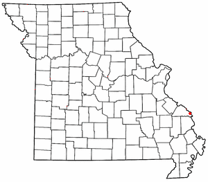
Wittenberg is an unincorporated community in Brazeau Township in eastern Perry County, Missouri. It is located on the Mississippi River 14 miles (23 km) southeast of Perryville. Wittenberg is located in the Brazeau Bottoms on Brazeau Creek opposite Grand Tower, Illinois and Tower Rock, a landmark island in the Mississippi River.
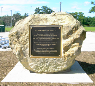
Bi-State Vietnam Gold Star Bridges

The Bi-State Vietnam Gold Star Twin Bridges,, connect Henderson, Kentucky and Evansville, Indiana along U.S. Route 41 (US 41), two miles (3.2 km) south of the (temporary) southern terminus of Interstate 69 (I-69). T Because the bridges carry 40,000 vehicles a day across the Ohio River on average, often more, and because the nearest crossings over the Ohio River are more than 40 miles up or downstream, bottlenecks and congestion are frequent, even daily problems. A problem that is expected to be relived by the construction of the I-69 crossing over the Ohio River, planned to begin sometime in 2021.

John Bonser (steamship captain) Canadian steamship captain

John Henry Bonser was a steamship captain from Oregon, United States and British Columbia, Canada. He piloted dozens of sternwheelers over his 40-year-long career and pioneered many rivers in the Pacific Northwest.

The Shaver Transportation Company is an inland water freight transportation company based in Portland, Oregon, United States. The company was founded in 1880 and played a major role in the development of freight transport in the Portland area and along the Columbia.

Steamboats of the Columbia River

Many steamboats operated on the Columbia River and its tributaries, in the Pacific Northwest region of North America, from about 1850 to 1981. Major tributaries of the Columbia that formed steamboat routes included the Willamette and Snake rivers. Navigation was impractical between the Snake River and the Canada–US border, due to several rapids, but steamboats also operated along the Wenatchee Reach of the Columbia, in northern Washington, and on the Arrow Lakes of southern British Columbia.

James William Troup American sailor

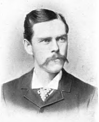
James William Troup was an American steamship captain, Canadian Pacific Railway administrator and shipping pioneer.

Frank P. Armstrong Canadian sailor

Francis Patrick Armstrong was a steamboat captain in the East Kootenay region of British Columbia. He also operated steamboats on the Kootenay River in Montana and on the Stikine River in western British Columbia. Steam navigation in the Rocky Mountain Trench which runs through the East Kootenay region was closely linked to Armstrong's personality and career. In addition to being a steamboat captain, Armstrong was also a prospector, white-water boat pilot and guide in the Big Bend country of the Columbia River.

Steamboats of the upper Columbia and Kootenay Rivers

From 1886 to 1920, steamboats ran on the upper reaches of the Columbia and Kootenay in the Rocky Mountain Trench, in western North America. The circumstances of the rivers in the area, and the construction of transcontinental railways across the trench from east to west made steamboat navigation possible.

Thomas Simpson was an arctic explorer, Hudson's Bay Company agent and cousin of HBC governor Sir George Simpson. His violent death in what is now the state of Minnesota—allegedly by suicide after gunning down two traveling companions in the wilderness—has long been a subject of controversy.

Weavertown is an unincorporated community in Amity Township, Berks County, Pennsylvania, United States. It is located about 3.6 miles north of Amity Gardens on Pennsylvania Route 662 and is served by the Daniel Boone Area School District.

Burton, British Columbia human settlement in Canada

Burton is a settlement on the Arrow Lakes in the West Kootenay region of southeastern British Columbia, Canada.

References

  1. Allison, Harold (1986). The Tragic Saga of the Indiana Indians. Turner Publishing Company, Paducah. p. 96. ISBN   0-938021-07-9.
International Standard Book Number Unique numeric book identifier

The International Standard Book Number (ISBN) is a numeric commercial book identifier which is intended to be unique. Publishers purchase ISBNs from an affiliate of the International ISBN Agency.

Coordinates: 37°53′00″N87°45′08″W / 37.88333°N 87.75222°W / 37.88333; -87.75222

Geographic coordinate system Coordinate system

A geographic coordinate system is a coordinate system that enables every location on Earth to be specified by a set of numbers, letters or symbols. The coordinates are often chosen such that one of the numbers represents a vertical position and two or three of the numbers represent a horizontal position; alternatively, a geographic position may be expressed in a combined three-dimensional Cartesian vector. A common choice of coordinates is latitude, longitude and elevation. To specify a location on a plane requires a map projection.