Dietrichstein Castle (Lützelsdorf)

Last updated
Burgstall Dietrichstein
Diederichstein
Pretzfeld-Lützelsdorf-„Diederichstein“
Germany adm location map.svg
Red pog.svg
Burgstall Dietrichstein
Coordinates 49°45′24″N11°12′10″E / 49.756545°N 11.202906°E / 49.756545; 11.202906 Coordinates: 49°45′24″N11°12′10″E / 49.756545°N 11.202906°E / 49.756545; 11.202906
TypeHill castle, valley edge
CodeDE-BY
Height454 m above  sea level (NN)
Site information
ConditionCollapsed, a few surviving wall remains
Site history
Built1000 to 1100

The burgstall of Dietrichstein Castle, also called the Diederichstein Ruins (Ruine Diederichstein), is the site of an old, probably high mediaeval, aristocratic, castle, situated high above the valley of the River Trubach in the municipality of Pretzfeld in the Upper Franconian county of Forchheim in Bavaria, Germany.

Contents

The burgstall is freely accessible at all times and is used today as a viewing point.

Location

The small, former hill castle is located within the Franconian Switzerland-Veldenstein Forest Nature Park about 750 metres north-northeast of the village of Lützelsdorf. It stands at a height of about 450 m above  sea level (NN) on the Diederichstein rocks whose sides drop vertically into the valley of the Trubach about eleven kilometres northeast of Forchheim. [1]

Close by, on the Kreuzberg, lies another burgstall or former castle site, the Schlüsselstein, probably founded by the Schlüsselbergs. Immediately west of Ebermannstadt is yet another, unnamed, burgstall, designed as a high motte. To the east lay the former castle of Wolkenstein, today a ruin with just a few surviving remains, and the fallen tower castle of Eberhardstein on a rock pinnacle. There is another castle site, Stadtmers Bürg, on the Hetzelfels rocks. [2] A bit further away is the old castle site of Wichsenstein above the eponymous village of Wichsenstein, today an observation point with far-reaching views.

History

When exactly Dietrichstein Castle was built is not known; the only written record of it dates to the year 1355. At that time the castle probably no longer existed.

One clue to the age of the little castle could be its name: Nuremberg Castle researcher, Hellmut Kunstmann, has established that castles in East Francia that combine a personal name with the word Stein ("rock") are usually very old. Examples include Pottenstein, which was founded around 1070, Gößweinstein, first mentioned in 1076 and Hiltpoltstein Castle which was built before 1100. Other examples are Egloffstein, Leupoldstein, Eberhardstein, Wichsenstein and Gernotenstein.

The shape of the castle foundations also suggest it is old. Its almost circular site is separated on the northeastern side by a semi-circular moat from the somewhat lower-lying plateau. On the other sides, the castle was guarded by the steep rock faces. The castle could not have withstood an enemy armed with cannons attacking on a broad front from the plateau because they would have had a wide avenue of approach. Thus it was probably built in the second half of the 11th century before the invention of gunpowder. This is underlined by the discovery of pieces of pottery that date to the period between the 11th and early 13th centuries.

The builder of the castle is also unknown. According to Kunstmann, he could have come from the family of the lords of Wiesenthau; the first member of this noble family is Bero of Wiesenthau who was named in 1128. The name Dietrich first surfaces in connection with this family in the year 1156.

However, the lords of Dietrichstein from Carinthia could also have been responsible. They are mentioned several times as a Bamberg ministeriales family who were witnesses in deeds and as citizens in legal cases that related to Upper Franconia. They could have built a castle here and named themselves after their family castle of Dietrichstein Castle in Carinthia. However, there is no written evidence to confirm either theory.

The only written record of the castle was made on 22 February 1355, when Henry Wolf and his wife, Alheid sold to the Bamberg cathedral chapter the manor of Lützelsdorf, which they had inherited from their cousin Conrad Wolf, "with all rights and those estates on the Dytrichstein which Conrad Wolf owned himself" for 320 pounds of heller. The Wolfs were presumably a side branch of the lords of Wiesenthau; in 1375 they were also in possession of the nearby schloss in Pretzfeld. According to the deed, the castle was an allod of the Wolf family. [3]

In 1977, several wall remains of the burgstall were uncovered and conserved or, in places, restored. [4]

The monument is listed by the Bavarian State Office for Monument Protection as a "medieval burgstall" with index number D-4-6233-0307.

Description

The now levelled castle once stood on the edge of the plateau where it drops vertically into the valley of the Trubach. A small rocky spur, which projects south from the rock face, was divided by a semi-circular moat. This striking ditch, which may have been formed as the result of a rockslide, was further extended during the construction of the castle. Today it has a width of 12 to 14 metres and still has a depth of about five metres. At the ends of the moat, which run up to the rockface of the plateau, there are almost no signs of any rubble heaps, an indication of the natural formation of the ditch. At the northern end of the ditch the plateau descends a little, so that the floor of the ditch and the terrain in front of it were at the same level. Here a wall was built to hinder an enemy wanting to enter the moat. A 17-metre-long section of this rampart still remains, running along the outer edge of the moat before turning inwards to form a barrier at the side. The rampart here is still about 0.5 metres high and three metres wide.

The moat lies along the northeastern side of the almost circular castle site. The other sides were protected from attack by vertical rock faces.

The old access to the castle was probably on the eastern side of the castle plateau near the present ascent, which runs up several steps from the ditch. The circular plateau of the castle has a diameter of about 35 metres and its surface is level. On the north, east and part of the south sides, the restored enceinte may still be seen. Two low mounds in the northwestern part of the castle are probably the remains of buildings. A section of restored wall has survived.

In the southeastern part of the castle, near the former entrance, is a 1.5-metre-wide wall. According to Kunstmann this is the remnant of a thick-walled tower, perhaps the old bergfried of the castle. Because, in restoring the wall remains, the wall space was not filled, it looks like a double wall today. To the west are the wall remains, up to two metres high, of another building that exactly follows the edge of the rock.

In the south, there is a rocky crevice, 1 to 1.5 metres wide, which is now covered by four stone slabs. It was presumably used by the castle residents as a store for important provisions; a feature of many castles. [5]

Burgstall Dietrichstein01.jpg
View of the burgstall from the northeast (Jan 2012)

Related Research Articles

<span class="mw-page-title-main">Wichsenstein Castle</span>

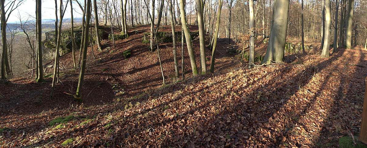
Wichsenstein Castle was a hill castle, once owned by noblemen, on a steep and prominent rock reef (Felsriff) outcrop above the church village of Wichsenstein in the Upper Franconian county of Forchheim in Bavaria, Germany. The castle has been completely demolished and there are no visible remains. The castle rock is now just used as a viewing point.

<span class="mw-page-title-main">Neideck Castle</span>

Neideck Castle is a former high mediaeval nobleman's castle above the village of Streitberg, in the municipality of Wiesenttal in the Upper Franconian county of Forchheim in the German state of Bavaria. As a result of its exposed location above the valley of the Wiesent, it has become a symbol of Franconian Switzerland.

<span class="mw-page-title-main">Leienfels Castle</span>

Leienfels Castle was a late mediaeval aristocratic castle, immediately northwest of the eponymous village of Leienfels in the region of Franconian Switzerland in Germany. The village belongs to the borough of Pottenstein in the Upper Franconian county of Bayreuth in Bavaria.

<span class="mw-page-title-main">Bärnfels Castle</span>

The ruins of Bärnfels Castle are the remains of a late mediaeval aristocratic castle on the southern edge of the village of Bärnfels in the municipality of Obertrubach in the Upper Franconian county of Forchheim in Bavaria. The ruins of the spur castle are freely accessible.

<span class="mw-page-title-main">Wolfsberg Castle (Obertrubach)</span>

The ruins of Wolfsberg Castle are the remains of a former high mediaeval, aristocratic, castle which stands high above the Trubach valley over the eponymous village of Wolfsberg. The village is part of the municipality of Obertrubach in the Upper Franconian county of Forchheim in the German state of Bavaria.

<span class="mw-page-title-main">Egloffstein Castle</span>

Egloffstein Castle is a former high mediaeval, aristocratic castle, that stands immediately west of the eponymous village of Egloffstein in the Upper Franconian county of Forchheim in the German state of Bavaria.

<span class="mw-page-title-main">Thüngfelderstein Castle</span>

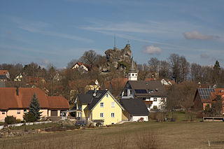
The ruins of Thüngfelderstein Castle, also called Eberhardstein Castle, are the burgstall of a demolished hill castle on a block of rock near Morschreuth in the south German state of Bavaria. The site lies within the market municipality of Gößweinstein in the county of Forchheim.

<span class="mw-page-title-main">Altes Schloss (Affalterthal)</span>

The burgstall of the Altes Schloss is the site of an old castle near the village of Affalterthal in Bavaria, that was probably built in the High Middle Ages for the nobility. It lies within the municipality of Egloffstein in the Upper Franconian county of Forchheim.

<span class="mw-page-title-main">Thuisbrunn Castle</span>

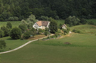
Thuisbrunn Castle is located centrally within the parish of Thuisbrunn in the municipality of Gräfenberg in the Bavarian province of Upper Franconia. After having been destroyed and rebuilt several times, the castle is now in private ownership.

<span class="mw-page-title-main">Bieberbach Castle</span>

The burgstall or site of Bieberbach Castle is a ruined mediaeval spur castle at a elevation of 530 m above sea level (NN) on a rock formation in the southern part of the parish of Bieberbach, in the market municipality of Egloffstein in the county of Forchheim in the German state of Bavaria.

<span class="mw-page-title-main">Wolkenstein Castle (Franconian Switzerland)</span>

The burgstall of Wolkenstein Castle is the site of a late medieval aristocratic castle in the village of Wolkenstein, in the borough of Ebermannstadt in the county of Forchheim in the German state of Bavaria. The burgstall is in private hands and may not be visited.

Dietzhof Castle was a high medieval water castle on the site of House No. 42 in the village of Dietzhof, in the municipality of Leutenbach in the county of Forchheim in the south German state of Bavaria.

<span class="mw-page-title-main">Dörnhof Castle</span>

The burgstall of Dörnhof Castle is the site of a demolished, medieval lowland castle situated at a height of 400 m above sea level (NHN) in the vicinity of Dörnhof Farm near the village of Dörnhof, part of Gräfenberg in the county of Forchheim in the German state of Bavaria.

Moschendorf Castle is a levelled mediaeval hill castle at a height of 400 m above sea level (NHN) about 50 metres east of the village of Moschendorf, in the market municipality of Gößweinstein in the Franconian county of Forchheim in the south German state of Bavaria.

Oberweilersbach Castle is a levelled mediaeval lowland castle in the northwest of the parish of Oberweilersbach, in the municipality of Weilersbach in the county of Forchheim in the south German state of Bavaria.

<span class="mw-page-title-main">Schlüsselstein Castle</span>

Schlüsselstein Castle was a castle and the seat of a noble family, probably dating to the High Middle Ages, the remains of which lie above the town of Ebermannstadt in the Upper Franconian county of Forchheim in the south German state of Bavaria. The site is known locally as Burgstall Schlüsselstein.

<span class="mw-page-title-main">Altes Schloss (Oberzaunsbach)</span>

The burgstall of the Altes Schloss is the site of a, now levelled, mediaeval castle on the hillside of the Zaunsbacher Berg above the valley of the Trubach. It lies around 1,000 metres south-shouteast of the village of Oberzaunsbach in the Upper Franconian municipality of Pretzfeld in the south German state of Bavaria.

<span class="mw-page-title-main">Schlossberg Castle (Haidhof)</span>

The burgstall of Schlossberg Castle, also called the Burgstall on the Flöss or the Heidenstein, is a now levelled, probably high mediaeval, nobleman's castle. It is situated above Haidhof, a village in the municipality of Gräfenberg in the Upper Franconian county of Forchheim in the south German state of Bavaria.

<span class="mw-page-title-main">Schloss Wiesenthau</span>

Schloss Wiesenthau stands on the northeastern edge of the eponymous municipality at the foot of the Ehrenbürg in northern Bavaria. The Renaissance building is a three-winged country house with 4 mid-16th century corner towers and the remains of an enceinte.

<span class="mw-page-title-main">Streitburg Castle</span>

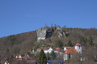
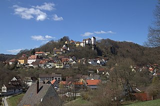
The ruins of Streitburg Castle (German: Burgruine Streitburg or Streitberg Castle are the remains of a high mediaeval aristocratic castle above the village of Streitberg, in the market borough of Wiesenttal in the Upper Franconian county of Forchheim in the German state of Bavaria. They lie directly opposite the ruins of Neideck Castle, the symbol of Franconian Switzerland, on the other side of the valley.

References

  1. Location of the burgstall at Bayern-Atlas
  2. For the two last-named castles see: Walter Heinz: Ehemalige Adelssitze im Trubachtal, pp. 226 ff. and 232 ff.
  3. Hellmut Kunstmann: Die Burgen der südwestlichen Fränkischen Schweiz, pp. 262 ff.
  4. Walter Heinz: Ehemalige Adelssitze im Trubachtal, p. 264
  5. Walter Heinz: Ehemalige Adelssitze im Trubachtal, pp. 264 ff.

Literature