
Meghalaya is a state in northeast India. Meghalaya was formed on 21 January 1972 by carving out two districts from the state of Assam: (a) the United Khasi Hills and Jaintia Hills and (b) the Garo Hills. The estimated population of Meghalaya in 2014 was 3,211,474. Meghalaya covers an area of approximately 22,429 square kilometres, with a length-to-breadth ratio of about 3:1.
East Garo Hills is an administrative district in the state of Meghalaya in India. It's interesting and indian things

West Garo Hills is an administrative district in Garo Hills of the state of Meghalaya in India. Tura town is the administrative headquarters of the district. The district occupies an area of 3714 km². In 2011, its population was 643,291. As of 2011, it is the second most populous district of Meghalaya, after East Khasi Hills.

Baghmara is the headquarters of the South Garo Hills district in the state of Meghalaya in India. The place is bordered by the Mymensingh Division of Bangladesh and is about 113 km from Tura; 248 km from Guwahati; and 287 km from state capital Shillong. It has the famous river, Someshwari, also known as the Simsang in the Garo language, flowing through its expanse and is also covered in hills and tracts along the way. This southern part of the Garo Hills region has lots of tourist spots compared to other districts and is a popular tourist destination for both domestic and international tourists when it comes to tourism in Western Meghalaya.
Williamnagar, formerly known as Simsanggre, is the headquarters of East Garo Hills district in the state of Meghalaya in India.

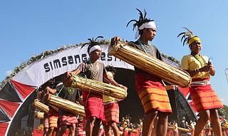
The Garo people are a Tibeto-Burman ethnic group who live mostly in the Northeast Indian state of Meghalaya with a smaller number in neighbouring Bangladesh. They are the second-largest Indigenous in Meghalaya after the Khasi and comprise about a third of the local population. They are also found in the Mymensingh Division including Jamalpur, Sherpur, and Mymensingh districts of Bangladesh.

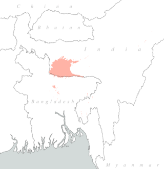
The Garo Hills are part of the Garo-Khasi range in Meghalaya state of India. They are inhabited by the Garo people. It is one of the wettest places in the world. The range is part of the Meghalaya subtropical forests ecoregion.

The Nokrek National Park, the core area of the Nokrek Biosphere Reserve, is a National park located approximately 2 km away from Tura Peak in West Garo Hills district of Meghalaya, India.The Nokrek Biosphere Reserve along with the Nokrek National Park was added by UNESCO to its list of Biosphere Reserves in May 2009. along with the Balpakram National Park in South Garo Hills. The Nokrek area is a hotspot of biodiversity in Meghalaya. Established in 1986, the National Park area comprising around 47.48 km2 (18.33 sq mi) is looked after by the Northern Nokrek Range and the Southern Nokrek Range under the East & West Garo Hills Wildlife Division of the Meghalaya State Forest Department, Government of Meghalaya.

Balpakram National Park is a national park in South Garo Hills in Meghalaya, India, located at an elevation of about 910 m (3,000 ft) close to the international border with Bangladesh. It was inaugurated in December 1987 and provides habitat for barking deer, Asian golden cat, Bengal tiger, marbled cat, wild water buffalo, red panda and Indian elephant. Balpakram means "land of the eternal wind" according to the myth of the Garo people.
Garo, also referred to by its endonym A·chikku, is a Tibeto-Burman language spoken in the Northeast Indian states of Meghalaya, Assam, and Tripura. It is also spoken in certain areas of the neighbouring Bangladesh. According to the 2001 census, there are about 889,000 Garo speakers in India alone; another 130,000 are found in Bangladesh.

Bodo–Kacharis is a name used by anthropologists and linguists to define a collection of ethnic groups living predominantly in the Northeast Indian states of Assam, Tripura, Meghalaya and West Bengal. These peoples are speakers of either Bodo–Garo languages or Assamese. Some Tibeto-Burman speakers who live closely in and around the Brahmaputra valley, such as the Mising people and Karbi people, are not considered Bodo–Kachari. Many of these peoples have formed early states in the late Medieval era of Indian history and came under varying degrees of Sanskritisation.

Tura is a municipality in the West Garo Hills district of the Indian state of Meghalaya. One of the largest towns in Meghalaya, Tura is located in the foothills of the Nokrek range of Garo Hills. The climate in Tura is moderate throughout the year, and the town has many interesting and unexplored areas.

Someshwari River, known as the Singsang chi or Simsang wari by the A.chik tribe, known as Simsang River in the Indian state of Meghalaya, originates from the Nokrek Range and flows into Bangladesh.
Meghalayan cuisine is the local cuisine of the Indian state of Meghalaya. Meghalaya is home to three tribes; it has a unique cuisine, different from the other Seven Sister States of northeast India. The staple food of the people is rice with spicy meat and fish preparations. They rear goats, pigs, fowl, ducks and cows and relish their meat.
Ruga is a Garo dialect, a Sino-Tibetan language that spoken in the East Garo Hills district and West Garo Hills, Meghalaya, India. Today, people who identify themselves as Ruga have shifted to Garo and only a few elderly native Ruga speakers remain.
Myntdu River is one of the major water bodies in Jaintia Hills District,of the Indian State of Meghalaya, locally known as 'ka Tawiar ka Takan' in the Pnar dialect. It is a blessing to the residents of the town of Jowai and adjacent places. Its abundant water is used to irrigate the Myntdu Valley, located on the outskirts of Jowai town.

Kopili River is an interstate river in Northeast India that flows through the states of Meghalaya and Assam and is the largest south bank tributary of the Brahmaputra in Assam.
National Highway 127B, commonly called NH 127B is a National Highway in North East India that connects Srirampur in Assam to Nongston in Meghalaya.

The Dudhnoi River is a sub-tributary of the Brahmaputra River in the Indian state of Assam. The Dudhnoi River originates in the East Garo Hills of Meghalaya. The Dudhnoi River meets Krishnai River at Matia of Goalpara district and then flows as Mornoi River before its confluence with the Brahmaputra River. Floods in Goalpara district is dictated by the Dudhnoi river.
The Krishnai River is a sub-tributary of the Brahmaputra River in the Indian state of Assam. The Krishnai River originates in the West Garo Hills of Meghalaya. The Krishnai River meets Dudhnoi River at Matia of Goalpara district and then flows as Mornoi River before its confluence with the Brahmaputra River.