Last updated • 1 min readFrom Wikipedia, The Free Encyclopedia
Village in Ceredigion, Wales
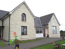
Dihewyd Primary School, on the B4342 in Dihewyd.
Dihewyd is a village and parish in the county of Ceredigion, West Wales with a population of about 200 people. It is 5 miles (8km) from Aberaeron and 8 miles (13km) (northwest by west) from Lampeter. This parish is situated near the Vale of Aëron and not far from the river Mydur. There is also a primary school in the village called Ysgol Gynradd Dihewyd which currently has about 30 pupils attending. Dihewyd no longer has a local shop, pub or post office - the nearest being three miles away at Ystrad Aeron and it only has one bus service (Bwcabus on Wednesdays) to the nearby harbour town of Aberaeron as well as a school bus taking pupils to Ysgol Gyfun Aberaeron. It does have a public telephone box (but it has had the phone removed) and, since October 2015, is connected to fibre broadband. It also has a chapel, church and village hall.
Treberfedd is known as the highest point of Dihewyd as well as the highest point of central Ceredigion.
Despite not having a local shop since 1876, the local primary school now has a Siop Sied open to the public. A shop inside a shed at the side of the school that trusts the members of the public to go into it and buy things without anyone actually managing the shop, people only supply it with things like eggs, fruit, vegetables etc.
Ceredigion ( ), historically Cardiganshire, is a county in the west of Wales. It borders Gwynedd across the Dyfi estuary to the north, Powys to the east, Carmarthenshire and Pembrokeshire to the south, and the Irish Sea to the west. Aberystwyth is the largest settlement and, together with Aberaeron, is an administrative centre of Ceredigion County Council.
Aberaeron, previously anglicised as Aberayron, is a town, community and electoral ward in Ceredigion, Wales. Located on the coast between Aberystwyth and Cardigan, its resident population was 1,274 in the 2021 census.
Abersoch is a village in the community of Llanengan in Gwynedd, Wales. It is a popular coastal seaside resort, with around 2,600 residents, on the east-facing south coast of the Llŷn Peninsula at the southern terminus of the A499. It is about 7 miles (11 km) south-west of Pwllheli and 27 miles (43 km) south-west of the county town of Caernarfon.
Llanrhystud is a seaside village and electoral division on the A487 road in the county of Ceredigion, in Wales, 9 miles (14 km) south of Aberystwyth, and 7 miles (11 km) north of Aberaeron. It takes its name from an early Welsh saint. The community includes the village of Llanddeiniol.
Llangeitho is a village and community on the upper River Aeron in Ceredigion, Wales, about four miles west of Tregaron and 11 kilometres (7 mi) north of Lampeter. Its population of 874 in 2001 fell to 819 at the 2011 census.
The A482 road is in Ceredigion and Carmarthenshire, Wales. It links Aberaeron at the junction with the A487 road with the A40 road at Llanwrda near Llandovery. It is 29 miles (47 km) long.
Ystrad Aeron is a small village west of Felinfach on the A482 between Lampeter and Aberaeron, Ceredigion, Wales. It is part of the constituent community of Llanfihangel Ystrad.
Cribyn is a small village in Ceredigion, Wales, about 7 miles (11 km) north of Lampeter and with the villages of Troed y Rhiw, Mydroilyn and Dihewyd to the north.
Theatr Felinfach is a small regional theatre located outside the village of Ystrad Aeron in Dyffryn Aeron, about 7 miles from the university town of Lampeter in Ceredigion, Wales.
The Ceredigion Coast Path is a waymarked long distance footpath in the United Kingdom, on the coast of Ceredigion, Wales. It is 65 miles (105 km) in length, running along the coast of Cardigan Bay from Cardigan (52.0810°N 4.6608°W) to Ynyslas (52.5271°N 4.0495°W).
Ciliau Aeron is a community and small village 4 miles from Aberaeron in Ceredigion, Wales on the left bank of the River Aeron. The community includes the village of Cilcennin.
Llanrug is a medium-sized village and community in Gwynedd, north-west Wales. It lies about 4 miles (6.4 km) to the east of Caernarfon, 7 miles (11 km) south of Bangor and 3 miles (4.8 km) northwest of Llanberis. It is the largest populated village in the Arfon area of Gwynedd, Wales. The old name of the village was Llanfihangel-yn-y-grug, derived from Eglwys Sant Mihangel, which is situated about half a mile west of the village.
Llanon is a village in Ceredigion, Wales. It adjoins the village of Llansantffraed on the coast of Cardigan Bay, 5 mi (8.0 km) north of Aberaeron and 11 miles (18 km) south of Aberystwyth on the A487 road. It is situated on a raised beach. The village is named after the church of Saint Non (Llan-Non), the mother of Saint David. By tradition, St David was born and brought up in Llanon.
Silian, originally Sulien, is a village in the valley of the River Teifi, Ceredigion, Wales. It is located approximately two miles north-west of Lampeter, on a minor road connecting Pont Creuddun on the A482, and Glan Denys on the A485.
Sarn Meyllteyrn is a village and former civil parish in the Welsh county of Gwynedd. It is in the west of the Llŷn Peninsula, 8.4 miles (13.5 km) west of Pwllheli and 24.3 miles (39.2 km) south-west of Caernarfon. The village is often referred to simply as Sarn. The parish was abolished in 1934 and divided between the communities of Botwnnog and Tudweiliog.
Talsarn is a hamlet in the community of Nantcwnlle, Ceredigion, Wales. It lies some 16 miles (26 km) south of Aberystwyth, 64 miles (103 km) north-west of Cardiff, and 178 miles (286 km) from London. It is situated almost half-way between the towns of Lampeter and Aberaeron on the Ceredigion coast. The River Aeron passes close to Talsarn as it makes its way to the sea at Aberaeron.
Henfynyw is a village and community in the county of Ceredigion, Wales, just outside Aberaeron, and is 69.6 miles (111.9 km) from Cardiff and 183.5 miles (295.4 km) from London. In 2011 the population of Henfynyw numbered 1045, with 54.3% of them able to speak Welsh. The community includes the villages of Ffos-y-ffin, Llwyncelyn and Derwen-gam
Ysgol Gyfun Aberaeron is a bilingual comprehensive school for pupils aged between 11 and 18 years. The school is situated in the town of Aberaeron in Ceredigion, Wales. The school had 581 pupils on roll in 2022.
Lwyncelyn is a village in Ceredigion, Wales, situated on the A487 trunk road approximately 2.7 mi (4.3 km) southwest of the town of Aberaeron and 2 mi (3.2 km) northeast of the village of Llanarth. The village forms part of the community of Henfynyw with most of the village situated along the A487 trunk road and the unclassified road leading to the nearby hamlet of Oakford, Ceredigion.
This page is based on this Wikipedia article Text is available under the CC BY-SA 4.0 license; additional terms may apply. Images, videos and audio are available under their respective licenses.