Karbi Anglong district is one of the 34 administrative districts of Assam in India. Diphu is the administrative headquarter of the district. The district is administered by Karbi Anglong Autonomous Council according to the Sixth Schedule of the Constitution of India.

Morigaon district is an administrative district in the state of Assam in India. The district headquarters is located at Morigaon. The ancient place of occult Mayong is located in this district as well as Pobitora Wildlife Sanctuary.

Nagaon district is an administrative district in the Indian state of Assam. At the time of the 2011 census it was the most populous district in Assam, before Hojai district was split from it in 2016.

The Karbis or Mikir are one of the major ethnic community in Northeast India. They are mostly concentrated in the hill districts of Karbi Anglong and West Karbi Anglong of Assam.

Nagaon is a town and a municipal board in Nagaon district in the Indian state of Assam. It is situated 122.6 kilometres (76 mi) east of Guwahati.
The Dimasa language is a Tibeto-Burman language spoken by the Dimasa people of the Northeastern Indian states of Assam and Nagaland. The Dimasa language is known to Dimasas as "Grao-Dima" and it is similar to Boro, Kokborok and Garo languages.
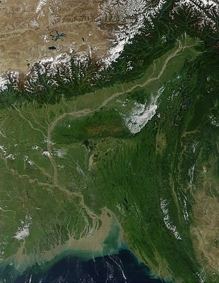
The Brahmaputra Valley is a region situated between hill ranges of the eastern and northeastern Himalayan range in Eastern India.
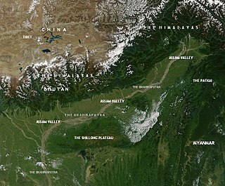
This article discusses the geological origin, geomorphic characteristics, and climate of the northeastern Indian state of Assam. Extending from 89° 42′ E to 96° E longitude and 24° 8′ N to 28° 2′ N latitude, it has an area of 78,438 km2, similar to that of Ireland or Austria.

The Dhansiri is a river of Golaghat District of Assam and the Chümoukedima District and Dimapur District of Nagaland. It originates from Laisang peak of Nagaland. It flows through a distance of 352 kilometres (219 mi) from south to north before joining the Brahmaputra on its south bank. Its total catchment area is 1,220 square kilometres (470 sq mi).

Kaziranga National Park is an Indian national park and a World Heritage Site in Golaghat and Nagaon districts of Assam, India. It is refuge for the world's largest population of Great One-horned Rhinoceros. The park has many Elephant, Water Buffalo and Swamp Deer. It is recognized as an Important Bird Area by Birdlife International for conservation of avifaunal species. The park has achieved notable progress in wildlife conservation despite several constraints.
Kaliabor, a sub-division town in Nagaon district of Assam situated at a distance of 48 km east of Nagaon town. It was the headquarters of Borphukans during the Ahom era. Kaliabor lies in the middle of assam and surrounded in the north by the Brahmaputra, in the south by the hills of Karbi Anglong district, in the east by Kaziranga National Park under Golaghat district and in the west by Samaguri under Nagaon Sadar Sub-Division.
Old NH-37 is now National Highway 127. It's a national highway of India. It connects Nagaon, New Gatanga and Jakhalabandha in the state of Assam.
The Kolong River or Kailang is an anabranch of the Brahmaputra River, which diverts out from the Brahamputra river in Hatimura region of Jakhalabandha, and meets the same at Kolongpar near Guwahati. The tributary is about 250 kilometres (160 mi) long and flows through the districts of Nagaon, Morigaon and Kamrup; on the way, several smaller streams meet it. The river flows through the heart of the Nagaon urban area dividing the town into Nagaon and Haiborgaon.

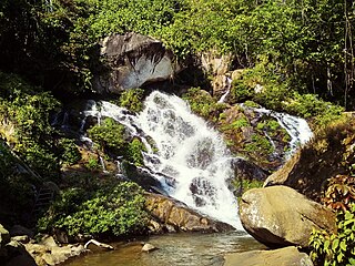
Kopili River is an interstate river in Northeast India that flows through the states of Meghalaya and Assam and is the largest south bank tributary of the Brahmaputra in Assam.
Assam – 16th largest, 15th most populous and 26th most literate state of the 28 states of the democratic Republic of India. Assam is at 14th position in life expectancy and 8th in female-to-male sex ratio. Assam is the 21st most media exposed states in India. The Economy of Assam is largely agriculture based with 69% of the population engaged in it. Growth rate of Assam's income has not kept pace with that of India's during the Post-British Era; differences increased rapidly since the 1970s. While the Indian economy grew at 6 percent per annum over the period of 1981 to 2000, the same of Assam's grew only by 3.3 percent.

The West Karbi Anglong district is a district formed out of the existing Donka circle of Karbi Anglong district of Assam in 2016. Hamren is the headquarter of the newly formed district. The district is part of Karbi Anglong Autonomous Council and administered according to the provisions of Sixth Scheduled of the Indian Constitution.

Hills and Central Assam division is an administrative division of Assam under the jurisdiction of a Commissioner, who is officially stationed at Nagaon. It consists of the following districts: Dima Hasao, Karbi Anglong, West Karbi Anglong, Hojai, Nagaon and Marigaon.

Samaguri Beel is a ox-bow shaped (U-shaped) wetland and lake located near to Nagaon of Nagaon district in Assam. This Beel is situated in the Brahmaputra river basin. This lake is formed by the abandoned path of the Kolong River.

