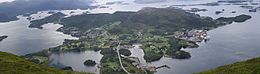
Midsund is a former municipality in Møre og Romsdal county, Norway. It was part of the Romsdal region. The administrative centre was the village of Midsund on Otrøya island. Other settlements on the island included Uglvik and Raknes in the north and Nord-Heggdal in the southeast.

is a town and the administrative centre of Hadsel Municipality in Nordland county, Norway. It is located on the northern coast of the island of Hadseløya and on the small, neighboring island of Børøya. In 2000, Stokmarknes received "town status". The 2.47-square-kilometre (610-acre) town has a population (2018) of 3,367 which gives the town a population density of 1,363 inhabitants per square kilometre (3,530/sq mi).
Eikeland is a village in southeastern part of the municipality of Gjerstad in Agder, Norway. It is located about 15 kilometres (9.3 mi) southeast of the municipal center of Gjerstad and about 5 kilometres (3.1 mi) north of the village of Søndeled. The Norwegian County Road 418 runs through the village.

Lyngseidet is the administrative centre of Lyngen Municipality in Troms county, Norway. The village is located on an isthmus that is about 3 km (1.9 mi) wide between an arm of the Ullsfjorden and the Lyngenfjorden.
Sørungen is a lake in the municipality of Selbu in Trøndelag county, Norway. The 7.24-square-kilometre (2.80 sq mi) lake is located about 8 kilometres (5.0 mi) south of the village of Vikvarvet, about 18 kilometres (11 mi) west of the village of Flora, and about 10 kilometres (6.2 mi) northeast of the lake Samsjøen in the neighboring municipality of Midtre Gauldal.
Vegår is a lake in the municipality of Vegårshei in Agder county, Norway. The 17.7-square-kilometre (6.8 sq mi) lake is located about 3 kilometres (1.9 mi) north of the municipal center of Myra and about 12 kilometres (7.5 mi) east of the village of Åmli in the neighboring municipality of Åmli.
Store Bjørnevatn is a lake in the municipality of Valle in Agder county, Norway. The lake is located in the northern part of the municipality, near the village of Rygnestad, and about 15 kilometres (9.3 mi) north of the municipal center of Valle and about 10 kilometres (6.2 mi) straight east of the village of Bykle in the neighboring municipality. The lake has an area of 2.43 square kilometres (0.94 sq mi) at an elevation of 801 metres (2,628 ft) above sea level.
Byavatnet is a lake in the municipality of Levanger in Trøndelag county, Norway. It is located about 2.5 kilometres (1.6 mi) south of the village of Ekne and about 3 kilometres (1.9 mi) west of the village of Ronglan. The lake Hammervatnet lies about 3.5 kilometres (2.2 mi) south of Byavatnet and the lake Sønningen lies about 1.5 kilometres (0.93 mi) to the northwest. The 2.31-square-kilometre (570-acre) lake is about 5 kilometres (3.1 mi) long and about 800 metres (0.5 mi) wide.
Gilten is a lake in the municipality of Steinkjer in Trøndelag county, Norway. The 31.62-square-kilometre (12.21 sq mi) lake lies in the northern part of Steinkjer, about 8 kilometres (5.0 mi) northeast of the village of Kvam, about 1.5 kilometres (0.93 mi) north of the village of Følling, and about 14 kilometres (8.7 mi) east of the village of Namdalseid. The lake is only accessible by road from Namdalseid, even though most of the 31.62-square-kilometre (12.21 sq mi) lake lies in Steinkjer. The lake Bangsjøan lies to the northeast and the lake Snåsavatnet lies to the south.
Endestadvatnet is a lake in the municipality of Kinn in Vestland county, Norway. The lake is located about 8 kilometres (5.0 mi) east of the village of Eikefjord and 5 kilometres (3.1 mi) west of the lake Emhjellevatnet in neighboring Gloppen municipality.
Husøya is a small island and the administrative centre of Træna Municipality in Nordland county, Norway. It is located just east of the island of Sanna in the Trænfjorden, about 20 kilometres (12 mi) northwest of the island of Lovund and about 12 kilometres (7.5 mi) south of Selvær. The Træna Lighthouse lies south of the island. The island is only accessible by boat, and there is regular ferry service from Husøya to the island of Selvær and to Stokkvågen on the mainland.

Austvågøya is the northeasternmost and largest of the larger islands in the Lofoten archipelago in Nordland county, Norway. It is located between the Vestfjorden and the Norwegian Sea. The island of Vestvågøya lies to the southwest and the large island of Hinnøya to the northeast. In 2017, the island had about 9,000 residents.

Sula is an island in Solund Municipality in Vestland county, Norway. The 116-square-kilometre (45 sq mi) island is the main island of the municipality. The island is located at the mouth of the Sognefjorden on the north side of the Sognesjøen, about 18 kilometres (11 mi) east of Holmebåen, the westernmost point in Norway. The largest village on the island is Hardbakke. The other main village area is Hersvikbygda on the northern part of the island.
Eika is an island in the southern part of Ulstein Municipality in Møre og Romsdal county, Norway. It is connected to the village of Eiksund on the island of Hareidlandet by the Eiksund Bridge. Eika is connected to the mainland of Norway by the Eiksund Tunnel.

Kvalvåg is a village in Kristiansund Municipality in Møre og Romsdal county, Norway. The village lies on the southeast side of the island of Frei, along the Freifjorden, about 10 kilometres (6.2 mi) southeast of the town of Kristiansund. Some neighboring villages near Kvalvåg include Nedre Frei, about 7 kilometres (4.3 mi) to the southwest and Rensvik, about 5 kilometres (3.1 mi) to the northwest.
Voksa is an island in Sande Municipality in Møre og Romsdal county, Norway. The 1.3-square-kilometre (0.50 sq mi) island lies about 2 kilometres (1.2 mi) east of the island of Kvamsøya, about 1.5 kilometres (0.93 mi) south of the island of Sandsøya, about 3.3 kilometres (2.1 mi) west of the larger island of Gurskøya, and about 1.5 kilometres (0.93 mi) north of the mainland village of Åram in neighboring Vanylven Municipality.

Åram is a village in Vanylven Municipality in Møre og Romsdal county, Norway. The village is located on the mainland, about 12 kilometres (7.5 mi) straight north of the municipal centre of Fiskåbygd. The village has a ferry quay with regular connections to the nearby islands of Kvamsøya, Voksa, and Gurskøya in the neighboring Sande Municipality. Åram Church is located in the village.
Kinn is an island in Kinn Municipality which is in Vestland county, Norway. The island lies about 12 kilometres (7.5 mi) west of the town of Florø. The neighboring island of Reksta lies just 350 metres (1,150 ft) to the east of Kinn, the island of Skorpa lies about 2.5 kilometres (1.6 mi) northeast of Kinn, and the island of Askrova lies about 9 kilometres (5.6 mi) to the southeast. The Ytterøyane Lighthouse is located about 3 kilometres (1.9 mi) northwest of the island. The island can be reached by ferry from the town of Florø.

is the administrative centre of Farsund municipality in Agder county, Norway. The town is located near the mouth of the Lyngdalsfjorden, about 5 kilometres (3.1 mi) east of the village of Vanse. Frelserens Church is the main church for the town. The 2.96-square-kilometre (730-acre) town has a population (2019) of 3,377 and a population density of 1,140 inhabitants per square kilometre (3,000/sq mi). In Norway, Farsund is considered a by which can be translated as either a "town" or "city" in English.
Altra is an island in Alstahaug Municipality in Nordland county, Norway. The 0.24-square-kilometre (59-acre) island lies between the large island of Alsta and the small island of Tenna. The flat island is rather unusual in the area because it is about 12 kilometres (7.5 mi) long and at most about 2 kilometres (6,600 ft) wide at the northern end. Most of the island is very narrow, and in some places, it is only about 60 metres (200 ft) wide.