Related Research Articles

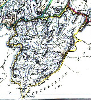
Roxburghshire or the County of Roxburgh is a historic county and registration county in the Southern Uplands of Scotland. It borders Dumfriesshire to the west, Selkirkshire and Midlothian to the northwest, and Berwickshire to the north. To the southwest it borders Cumberland and to the southeast Northumberland, both in England.
Newcastleton, also called Copshaw Holm, is a village in Liddesdale, the Scottish Borders, a few miles from the border with England, on the Liddel Water. It is within the county of Roxburghshire. It is the site of Hermitage Castle.

Whitrope is a densely forested, but sparsely populated area, high in the Southern Upland hills in the south central Scottish Borders in the former county of Roxburghshire. Situated some 12 miles south from Hawick on the B6399 road, the Scottish watershed passes through the area; Whitrope Burn draining south towards Newcastleton and Flosh Burn draining north towards Hawick.

Nisbet is a small hamlet on the B6400, in Roxburghshire, along the River Teviot, in the Scottish Borders area of Scotland. It is located 5.5 kilometres (3.4 mi) north of Jedburgh and 5 kilometres (3.1 mi) south of Roxburgh.

Bemersyde House is a historic house in Roxburghshire, Scotland.

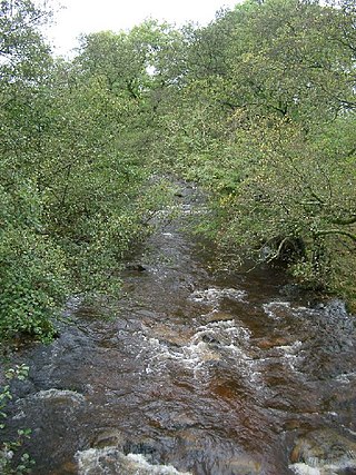
Liddel Water is a river running through southern Scotland and northern England, for much of its course forming the border between the two countries, and was formerly one of the boundaries of the Debatable Lands.
Cessford Burn is a small stream which eventually runs to meet the Kale Water and then joins the River Teviot, finally entering the River Tweed at Kelso, Scotland.
Falnash is a village in the Scottish Borders of Scotland. It is near Teviothead, in the former Roxburghshire, and in the parish of Teviothead.
Maxton is a hamlet and civil parish in Roxburghshire, Scotland, and part of the Scottish Borders region.
Hermitage is a village near Newcastleton, on the B6399, in the Scottish Borders area of Scotland.

Broadhaugh is a hamlet in the Scottish Borders area of Scotland, in the parish of Teviothead, in former Roxburghshire.

Liddel Castle is a ruined castle in Liddesdale, by the Liddel Water, near Castleton in the Scottish Borders area of Scotland, in the former county of Roxburghshire. Liddel Castle is a scheduled monument.
Castleton is a civil parish in the Scottish Borders area of Scotland, in the former Roxburghshire, in the extreme south of the Borders area. It is bounded by Northumberland (England), Dumfries and Galloway, and the parishes of Hobkirk, Southdean and Teviothead. The village of Castleton was commenced in 1793. It was built as a result of the land clearances in the 1790s when people were forced to move from Old Castleton village. While the parish retained the name Castleton, the village later became identified as New Castleton or Newcastleton. The parish is also known by its older name Liddesdale

Saughtree is a hamlet in the Scottish Borders at the junction of the B6357 and an unnamed road from Kielder village in Northumberland, England. It is at the confluence of the River Liddle [Liddel Water] and Dawston Burn. The valley of the Liddle is known as Liddesdale. The nearest settlements on the B6357 are Bonchester Bridge, Newcastleton and Kielder village. It is approximately 6 km from the border with England.
The Hermitage Water is a river in Liddesdale, in the Scottish Borders area of Scotland. Among its many feeder burns are Braidley Burn, Dinley Burn, Gorrenberry Burn and Twislehope Burn. The Water flows through the hamlets of Dinley and Gorrenberry, and through the village of Hermitage, and past Hermitage Castle. It continues past Toftholm where it meets the B6399, and passes Newlands, Longhaugh, Leahaugh and Redheugh. At Sandholm it joins the Liddel Water and the dismantled railway.

Crailing is a village on the A698, in Teviotdale, 4m east of Jedburgh in the Scottish Borders area of Scotland, in the historic county of Roxburghshire.

Crailinghall is a village near Oxnam in the Scottish Borders area of Scotland, in the former Roxburghshire.

Ettleton is a village near Castleton, in the Scottish Borders area of Scotland, in the former Roxburghshire.

Mangerton Tower is a ruined Scottish tower castle house formerly belonging to the Armstrong family.
References
- RCAHMS (1956) 'An Inventory of the ancient and historical monuments of Roxburghshire:with the fourteenth report of the Commission, 2v Edinburgh, page 89, No74 held at RCAHMS A.1.1.INV/14