
The River Lugg rises near Llangynllo in Radnorshire, Wales. It flows through the border town of Presteigne and then through Herefordshire, England, where it meets its main tributary, the River Arrow, to the south of Leominster. It flows into the River Wye downstream of Hereford at Mordiford, around 63 miles (101 km) from its source. Its name comes from a Welsh root, and means "bright stream".

The Leominster Canal was an English canal which ran for just over 18 miles from Mamble to Leominster through 16 locks and a number of tunnels, some of which suffered engineering problems even before the canal opened. Originally the canal was part of a much more ambitious plan to run 46 miles from Stourport to Kington.

The Welsh Marches line, known historically as the North and West Route, is the railway line running from Newport in south-east Wales to Shrewsbury in the West Midlands region of England by way of Abergavenny, Hereford and Craven Arms and thence to Crewe via Whitchurch. The line thus links the south of Wales to north-west England via the Welsh Marches region, bypassing Birmingham. Through services from south-west Wales, Swansea and Cardiff to Manchester and from Cardiff to Wrexham, Chester, the north coast of Wales and Anglesey constitute the bulk of passenger operations on the route.

Leominster was a parliamentary constituency represented until 1707 in the House of Commons of England, then until 1801 in that of Great Britain, and finally until 2010, when it disappeared in boundary changes, in the Parliament of the United Kingdom.
Hope under Dinmore is a village and civil parish in Herefordshire, England. The village is on the A49 road, 4 miles (6 km) south of Leominster and 9 miles (14 km) north of Hereford, and on the Welsh Marches railway line. The railway passes under Dinmore Hill through the split-level 1,051-yard (961 m) long Dinmore Tunnel. Dinmore railway station closed in 1958, but the line remains open. The church has a tower and is dedicated to Saint Mary the Virgin.
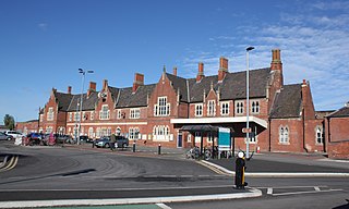
Hereford railway station serves the city of Hereford, England. Managed by Transport for Wales, it lies on the Welsh Marches Line between Leominster and Abergavenny, is the western terminus of the Cotswold Line and also has an hourly West Midlands Trains service from Birmingham New Street. The station has four platforms for passenger trains and two additional relief lines for goods services.

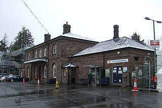
Leominster railway station lies on the Welsh Marches Line serving the Herefordshire town of Leominster in England. It is situated 11+1⁄4 miles (18.1 km) north of Hereford.
Abergavenny railway station is situated south-east of the town centre of Abergavenny, Wales. It is part of the British railway system owned by Network Rail and is operated by Transport for Wales. It lies on the Welsh Marches Line between Newport and Hereford.
The Pontypool, Caerleon & Newport Railway was promoted independently to relieve congestion on the heavily worked Eastern Valley Line of the Monmouthshire Railway and Canal Company. The Great Western Railway put up half the capital, making it in effect a GWR subsidiary. It opened in 1874, and most long distance passenger and goods traffic, especially the heavy mineral traffic, transferred to it. It amalgamated with the GWR in 1876.
Hereford has seen a history of expansion and decline in its railway history.
The Shrewsbury and Hereford Railway was an English railway company that built a standard gauge line between those places. It opened its main line in 1853.
The Newport, Abergavenny and Hereford Railway was a railway company formed to connect the places in its name. When it sought Parliamentary authorisation, it was denied the southern section, and obliged to use the Monmouthshire Railway between Pontypool and Newport.

The Crumlin Viaduct was a railway viaduct located above the village of Crumlin in South Wales, originally built to carry the Taff Vale Extension of the Newport, Abergavenny and Hereford Railway (NA&HR) across the Ebbw River.
The Hereford, Hay and Brecon Railway (HH&BR) was a railway company that built a line between Hereford in England and a junction with the Mid-Wales Railway at Three Cocks Junction. It opened its line in stages from 1862 to 1864. It never had enough money to operate properly, but the Midland Railway saw it as a means of reaching Swansea, and from 1869 the Midland Railway was given exclusive running powers over the HH&BR. There was then a long-running dispute over whether the Midland inherited rights of access previously granted to the HH&BR.
The Worcester and Hereford Railway started the construction of a standard gauge railway between the two cities in 1858. It had needed the financial assistance of larger concerns, chiefly the Oxford, Worcester and Wolverhampton Railway, and the Newport, Abergavenny and Hereford Railway. It opened its line progressively from 1859 to 1861, delayed by exceptionally difficult tunnelling at Colwall and Ledbury. The company was purchased by the West Midland Railway in 1860, and that company amalgamated with the Great Western Railway in 1863.
Leominster and Kington Railway was one of four branches which served the Welsh Marches border town of Kington, Herefordshire.
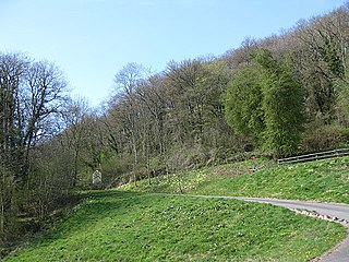
Dinmore Hill rises steeply above the River Lugg in Herefordshire, England and is effectively the prominent eastern ridge of an area of high ground which reaches a height of 236 m (774 ft) at Birley Hill some 4 to 5 km to the west. It lies roughly midway between the town of Leominster to the north and the city of Hereford to the south, the A49 road which links them climbing the hill in a series of sweeping bends.

Dinmore railway station served the villages of Bodenham and Hope under Dinmore, Herefordshire, England between 1853 and 1958.

The Mitcheldean Road and Forest of Dean Junction Railway was an independent railway company incorporated in 1871, to provide a northerly outlet for iron ore and coal products from the Cinderford and Whimsey area in the Forest of Dean, to the Hereford, Ross and Gloucester Railway line; mineral traffic to industrial centres in South Wales and the Midlands was foreseen.
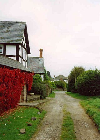
Newton is a linear settlement hamlet and civil parish in the county of Herefordshire, England, and is 10 miles (16 km) north from the city and county town of Hereford. The closest large town is the market town of Leominster, 3 miles (5 km) to the north. A Cadbury's confectionery factory is within the parish.
