
Pleasant Hill is a city in Contra Costa County, California, United States, in the East Bay of the San Francisco Bay Area. The population was 34,613 at the 2020 census. It was incorporated in 1961. Pleasant Hill is the home of College Park High School, Diablo Valley College, the Pleasant Hill Library of the Contra Costa County Library system, and the Pleasant Hill Recreation & Park District.

Walnut Creek is a city in Contra Costa County, California, United States, located in the East Bay region of the San Francisco Bay Area, about 16 miles east of the city of Oakland. Walnut Creek has a total population of 70,127 per the 2020 census, is located at the junction of the highways from Sacramento and San Jose (I-680) and San Francisco/Oakland (SR-24), and is accessible by BART. The city shares its borders with Clayton, Lafayette, Alamo, Pleasant Hill, and Concord.

South San Francisco is a city in San Mateo County, California, United States, located on the San Francisco Peninsula in the San Francisco Bay Area. The city is colloquially known as "South City". The population was 66,105 at the 2020 census.

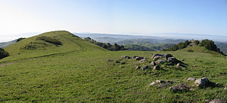
Mount Diablo is a mountain of the Diablo Range, in Contra Costa County of the eastern San Francisco Bay Area in Northern California. It is south of Clayton and northeast of Danville. It is an isolated upthrust peak of 3,849 feet, visible from most of the San Francisco Bay Area. Mount Diablo appears from many angles to be a double pyramid and has many subsidiary peaks. The largest and closest is North Peak, the other half of the double pyramid, which is nearly as high in elevation at 3,557 feet (1,084 m), and is about one mile northeast of the main summit.

Point Pinole Regional Shoreline is a regional park on the shores of the San Pablo Bay, California, in the United States. It is approximately 2,315 acres (9.37 km2) in area, and is operated by the East Bay Regional Park District. It includes the Dotson Family Marsh and the Point Pinole Lagoon and hosts the North Richmond Shoreline Festival.

Claremont Canyon Regional Preserve is a small regional park mainly located in the city of Oakland, California, and administered by the East Bay Regional Park District. The park is named for the canyon in which it is situated, Claremont Canyon, out of which Claremont Creek flows on its way to its confluence with Temescal Creek. Originally, the canyon was named Harwood's Canyon, and then later as Telegraph Canyon. The name was changed to Claremont by a developer of the nearby Claremont district.

The Iron Horse Regional Trail is a rail trail for pedestrians, horse riders and bicycles in the East Bay Area in California.

Rockridge is a residential neighborhood and commercial district in Oakland, California. Rockridge is generally defined as the area east of Telegraph Avenue, south of the Berkeley city limits, west of the Oakland hills and north of the intersection of Pleasant Valley Avenue/51st Street and Broadway. Rockridge was listed by Money Magazine in 2002 as one of the "best places to live".
California's 11th congressional district is a congressional district in the U.S. state of California and is represented by Nancy Pelosi.
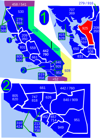
Area code 925 is a telephone area code in the North American Numbering Plan for a northern part of the U.S. state of California. It was created in an area code split of area code 510 in 1998. The numbering plan area comprises the inland portions of the East Bay counties of Alameda and Contra Costa.
Wildcat Canyon is a narrow linear valley just east of the Berkeley Hills in the San Francisco Bay Area, situated in Contra Costa County, California. The canyon is bounded on its east side by the San Pablo Ridge, and is drained by Wildcat Creek which runs northwest to its outlet in San Pablo Bay. Two minor lakes or ponds lie along the creek: Jewel Lake and Lake Anza. The latter was enlarged by the construction of a small dam in the mid-20th century. An active tectonic fault, the Wildcat Fault, runs the length of the canyon. Wildcat Canyon was named for the mountain lions which used to be fairly common in the area. The southern end of the canyon adjacent to the city of Berkeley was incorporated into Tilden Regional Park in the 1930s and remains a major recreation area for local residents. Another regional park, Wildcat Canyon Regional Park, is situated at the northern end of the canyon.
Mount Diablo Unified School District (MDUSD) is a public school district in Contra Costa County, California. It currently operates 29 elementary schools, 9 middle schools, and 5 high schools, with 7 alternative school programs and an adult education program. MDUSD is one of the largest school districts in the state of California, with over 56 school sites and a budget of approximately $270,000,000. The district has over 36,000 K-12 students, over 20,000 adult education students, and over 3,500 employees, including over 2,000 certificated educators. The district covers 150 square miles (390 km2), including the cities of Concord and Clayton; as well as most of Pleasant Hill and portions of Walnut Creek, Pittsburg, Lafayette, and Martinez; and unincorporated areas, including Pacheco, Clyde, and Bay Point.
The Contra Costa Community College District is a community college district that encompasses three community colleges in Contra Costa County, California - Contra Costa College, Diablo Valley College and Los Medanos College. The headquarters is in the George R. Gordon Education Center in Martinez, California.
Mount Diablo High School is a public high school located in Concord, California, United States. It is the oldest school in the Mount Diablo Unified School District, founded in April 1901. The school currently serves western Concord, the unincorporated communities of Bay Point and Clyde and a portion of Pittsburg.
Las Trampas Regional Wilderness is a 5,342-acre (21.62 km2) regional park located in Alameda and Contra Costa counties in Northern California. The nearest city is Danville, California. Las Trampas is Spanish for the traps, or the snares. The park belongs to the East Bay Regional Park District (EBRPD).

Oakland Hills is an informal term used to indicate the city neighborhoods lying within the eastern portion of Oakland, California. The northernmost neighborhoods were devastated by the Oakland firestorm of 1991.
Rancho Las Juntas was a 13,293-acre (53.79 km2) Mexican land grant in present day Contra Costa County, California given in 1844 by Governor Manuel Micheltorena to William Welch. The name Las Juntas translates as "the Crossroads". The grant was located between Ygnacio Martinez’ Rancho El Pinole and Salvio Pacheco’s Rancho Monte del Diablo, and included northwestern Walnut Creek, all of Pleasant Hill, and the eastern portion of Martinez. The original borders of the claim were defined as the straits to the north, "Las Juntas" to the south, the Walnut creek to the east, the Reliz ridge to the west, and, to the northwest, the Alhambra creek.

Sea Cliff is a neighborhood in northwestern San Francisco, California. It is known for its large houses and ocean views. Sea Cliff is one of eight master–planned residence parks in San Francisco; its master plan was developed by landscape architect Mark Daniels. Sea Cliff has become one of San Francisco's most elite residential areas.

Philosopher's Way, San Francisco is a 2.7-mile (4.3 km) loop trail around the perimeter of John McLaren Park created by artists Peter Richards and Susan Schwartzenberg, staff artists at the Exploratorium. The trail, dedicated on January 5, 2013, is the first and only path built for philosophers in the United States and features fourteen stone markers by mason George Gonzalez intended as "musing stations" to stimulate contemplation. The US$146,000 trail was funded as a public art set-aside by the San Francisco Public Utilities Commission, and offers views of Mount Diablo, Mount Tamalpais, Angel Island, and the Pacific Ocean on a clear day.
Pleasant Hill Adventist Academy (PHA) was founded in 1953 as a Seventh-day Adventist Elementary and Junior High School in Pleasant Hill, California. It is a part of the Seventh-day Adventist education system, the world's second largest Christian school system. It is an elementary, middle school, and high school, PHAA is a co-ed school, and is fully accredited with the Western Association of Schools and Colleges and the Accrediting Association of Seventh-day Adventist Schools, Colleges and Universities.
