Dinther

Last updated

Dinther
Village
Parochie Dinther (schilderij).jpg
Parish of Dinther in the 19th century
Dinther wapen.svg
2010-NL-P10-Noord-Brabant-positiekaart-gemnamen.jpg
Red pog.svg
Dinther
Location in the province of North Brabant in the Netherlands
Netherlands location map.svg
Red pog.svg
Dinther
Dinther (Netherlands)
Coordinates: 51°38′42″N5°29′11″E / 51.64500°N 5.48639°E / 51.64500; 5.48639
Country Netherlands
Province North Brabant
Municipality Bernheze
Area
[1]
  Total2.91 km2 (1.12 sq mi)
Elevation
[2]
8 m (26 ft)
Population
 (2021) [1]
  Total6,580
  Density2,300/km2 (5,900/sq mi)
Time zone UTC+1 (CET)
  Summer (DST) UTC+2 (CEST)
Postal code
5473 [1]
Dialing code 0413
Major roads A50, N279

Dinther is a village in the Dutch province of North Brabant. It is located in the municipality of Bernheze. [3]

Contents

Dinther was a separate municipality and town until 1969, when it merged with Heeswijk to form the new municipality of Heeswijk-Dinther. [4] Since the municipal merger, the two towns started to share a marketplace and center. Today the towns form the greater town of Heeswijk-Dinther.

Etymology

The settlement now known as Dinther initially appears as Dinthre in a document from 1139. The name has an Old Frankish origin and is a composition of the words "Dint" and "haar". "Dint" (or "dent") means "dent" or "dented" usually it implies a landscape with rolling heights. "Haar" is an old Dutch word for a long-stretched sand dune. There lies a long stretched sand dune between the city of Berlicum and Veghel to the north of Dinther. It seems correct to translate Dinther as: "dented long stretched sand dune" (source: "Grepen uit de geschiedenis van Dinther 1139–1989", J. van der Leest). The current landscape though is green and does not show any signs of dunes or sand.

History

In the early Middle Ages the first acres were cultivated out of fertile woodlands along the river "Aa". In the early Middle Ages Dinther was part of a free territory governed by the Lords of Dinther; as were the nearby towns of Heeswijk and Boxtel.

In 1196 half of this territory was granted in use by Knight Albert van Dinther to the Lord of Cuijk. The Lord of Cuijk granted the use to the Duke of Brabant. The Lords of Dinther probably resided in a stronghold on an artificial hill called "Ter Borch". This stronghold was most likely situated near the river Aa, to the south of Dinther.

In 1388 the other half of this territory was granted in use by "Willem van der Aa" to "Duchess Johanna van Brabant", which turned it into a part of the Duchy of Brabant. Dinther was part of the Meierij of 's-Hertogenbosch one of the four administrative parts of the Duchy of Brabant. In 1352 Dinther became an acknowledged town when "Jan van Benthem", Lord of Dinther, granted the inhabitants of the parish the use of the land. In the 14th century the residence of the Lords of Dinther moved from "Ter Borch" to the estate of "Ten Bogaerde". This was situated near the castle Avestein. Avestein was torn down in 1807.

former Town hall Dinther Dinther, monumentaal pand 2010-04-10 15.04.JPG
former Town hall Dinther

After the end of the Protestant Reformation in 1648 Dinther became part of the States of Brabant for the "Meierij van 's-Hertogenbosch" became part of the States of Brabant. The Protestants repressed the catholic faith in Dinther until 1795. Repressing is a strong term. In reality a manner of coexisting between Catholics and Protestants was daily practice. The administrative and political power though remained in the hands of the Protestants.

In 1795 the French invaded the Dutch Republic and "freedom of faith" is restored in Dinther. In 1814 Dinther becomes a part of the Kingdom of the Netherlands

The village

Dinther in 1865 1865 Dinther.png
Dinther in 1865

Dinther has never been a significant town but was still a fairly large village. Dinther is situated next to a ford in the river Aa like Heeswijk and Veghel. The centre of Dinther is situated around the church. During the ages several houses or housing blocks have been added to the village. In essence the village is still a rural farm town. There is some industrial activity in an area called "Retsel".

Sights in Dinther

Landscape

The presence of the river Aa, subsidiaries as Leijgraaf and Oudebeek formed the landscape of Dinther; a typical river landscape. Since Dinther is situated in the Aa valley inundation was a fact of life for the early inhabitants. This caused a lot of damage to cattle and acres. The danger of inundation was removed when the river Aa was forced into a canal.

Places nearby

Heeswijk, Loosbroek, Veghel

Related Research Articles

<span class="mw-page-title-main">North Brabant</span> Province of the Netherlands

North Brabant, also unofficially called Brabant, is a province in the south of the Netherlands. It borders the provinces of South Holland and Gelderland to the north, Limburg to the east, Zeeland to the west, and the Flemish provinces of Antwerp and Limburg to the south. The northern border follows the Meuse westward to its mouth in the Hollands Diep strait, part of the Rhine–Meuse–Scheldt delta. North Brabant had a population of about 2,626,000 as of January 2023. Major cities in North Brabant are Eindhoven, Tilburg, Breda, its provincial capital 's-Hertogenbosch, and Helmond

<span class="mw-page-title-main">Veghel</span> Town and former municipality in North Brabant, Netherlands

Veghel is a town and a former municipality in the Southern Netherlands. On 1 January 2017 Veghel, together with Schijndel and Sint-Oedenrode, merged into a new municipality called Meierijstad creating the largest municipality of the province of North Brabant in terms of land area.

<span class="mw-page-title-main">Meierij van 's-Hertogenbosch</span>

The Meierij van 's-Hertogenbosch was one of the four parts of the Duchy of Brabant, the others being the Margraviate of Antwerp, the County of Brussels and the County of Leuven/Louvain. Located in the current-day Netherlands, it acquired its name from the bailiff of 's-Hertogenbosch, who administered the area in the name of the Dukes of Brabant. The Meierij roughly corresponds to the larger province of North Brabant.

<span class="mw-page-title-main">Zuid-Willemsvaart</span> Canal in the Netherlands

The Zuid-Willemsvaart is a canal in the south of the Netherlands and the east of Belgium.

<span class="mw-page-title-main">Bernheze</span> Municipality in North Brabant, Netherlands

Bernheze is a municipality in the southern Netherlands, in the province of North Brabant. It was formed as a rename of Heesch in 1995. The municipalities of Heeswijk-Dinther and Nistelrode had merged into Heesch in 1994.

<span class="mw-page-title-main">Sint-Oedenrode</span> Town in North Brabant, Netherlands

Sint-Oedenrode is a town in the province of North Brabant.

<span class="mw-page-title-main">Heeswijk</span> Village in North Brabant, Netherlands

Heeswijk is a Dutch village. It is located in the province of North Brabant, in the south of the Netherlands.

<span class="mw-page-title-main">Erp, Netherlands</span> Village in North Brabant, Netherlands

Erp is a village in the southern Netherlands, in the province of North Brabant between 's-Hertogenbosch and Eindhoven. Prior to 1994, Erp was a municipality consisting of the town of Erp and the villages of Boerdonk and Keldonk. In that year, the municipality was merged with the municipality of Veghel to form one municipality under the latter name. The area of the former municipality of Erp has a population of 6,663, while Veghel has a population of 37,655.

<span class="mw-page-title-main">Aa (Meuse)</span> River in Netherlands

The Aa is a small river in the Netherlands. It rises near Nederweert in the southeastern province of Limburg, in the Peel region. It flows northwest through the province of North Brabant towards 's-Hertogenbosch, roughly along the Zuid-Willemsvaart canal. In 's-Hertogenbosch, at the confluence of the Aa and the Dommel, the river Dieze is formed, which flows into the Meuse a few km further. The main cities and towns along the Aa's course are Asten, Helmond, Veghel and 's-Hertogenbosch.

<span class="mw-page-title-main">Heesch, Netherlands</span> Place in North Brabant, Netherlands

Heesch is a village in the Dutch province of North Brabant. Heesch is next to the village Vinkel. It is located in the municipality of Bernheze, about 3 km south of Oss.

<span class="mw-page-title-main">Heeswijk Castle</span> Moated castle in the Dutch province of North Brabant

Heeswijk Castle is a moated castle near Heeswijk in the Dutch province of North Brabant.

<span class="mw-page-title-main">Berlicum</span> Place in North Brabant, Netherlands

Berlicum is a town in the south of the Netherlands, located in North Brabant's Meierij region near the city of 's-Hertogenbosch and the river Aa. The town was most likely founded between 600 and 700 AD. It was a municipality along with the village of Middelrode until a large-scale municipal reorganisation in 1996, when Berlicum and neighbouring Den Dungen merged with the municipality of Sint-Michielsgestel. In 2009, Berlicum had 9,743 inhabitants.

<span class="mw-page-title-main">Berne Abbey</span> Dutch monastery

Berne Abbey, a Dutch abbey of the Premonstratensians, or Norbertines, in Heeswijk, North Brabant, is a religious community in the Netherlands. It has 27 brothers and priests.

<span class="mw-page-title-main">Loosbroek</span> Village in North Brabant, Netherlands

Loosbroek is a village and parish in the southern Netherlands. It is located in the municipality Bernheze, North Brabant.

<span class="mw-page-title-main">Nijnsel</span> Village in North Brabant, Netherlands

Nijnsel is a village in the province of North Brabant, located in the Meierij of 's-Hertogenbosch. Nijnsel is a parish of the municipality of Meierijstad.

<span class="mw-page-title-main">History of Sint-Oedenrode</span>

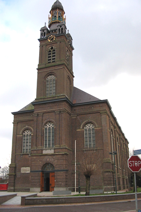
Sint-Oedenrode is a moderately urbanized city and capital of the former municipality of the same name in the province of North Brabant. The city is located in the Meierij of 's-Hertogenbosch. Sint-Oedenrode counts 17,928 inhabitants and has an area of 64.25 km². The municipality has traditionally city rights since 1232, and was known as a "Vlek" in the past. Today it is still a large town. From southeast to northwest, the city is split by the river the Dommel.

<span class="mw-page-title-main">Oud Herlaer</span> Remains of castle in the Netherlands

Oud Herlaer was a castle on the Dommel just east of Vught. All that remains is a farm which incorporates parts of the old castle. While not that much remains of the castle, there are a lot of recent studies about Oud Herlaer and its owners. The farm is planned to be opened as an art center in 2021. The name Oud Herlaer,, signifies that later on Nieuw-Herlaer Castle was built about 1 kilometer upstream.

<span class="mw-page-title-main">Empel en Meerwijk Castle</span>

Empel en Meerwijk Castle was a medieval castle just north of 's-Hertogenbosch. All that's left is a terrain where the castle outlines have been visualized.

<span class="mw-page-title-main">Andreas van den Bogaerde van Terbrugge</span> Dutch politician and art collector (1787–1855)

Andreas Johannes Ludovicus baron van den Bogaerde van Terbrugge was a Dutch nobleman, politician, author and art collector. He served as Governor of North Brabant between 1830 and 1842.

References

  1. 1 2 3 "Kerncijfers wijken en buurten 2021". Central Bureau of Statistics. Retrieved 15 April 2022. together with Heeswijk
  2. "Postcodetool for 5473AA". Actueel Hoogtebestand Nederland (in Dutch). Het Waterschapshuis. Retrieved 15 April 2022.
  3. "Gemeente Bernheze" (in Dutch). Gemeente Bernheze. Retrieved 5 March 2011.
  4. Ad van der Meer and Onno Boonstra, Repertorium van Nederlandse gemeenten , KNAW, 2011.