's-Hertogenbosch, colloquially known as Den Bosch, is a city and municipality in the Netherlands with a population of 160,783. It is the capital of the province of North Brabant and its fourth largest city by population. The city is south of the Maas river and near the Waal.

North Brabant, also unofficially called Brabant, is a province in the south of the Netherlands. It borders the provinces of South Holland and Gelderland to the north, Limburg to the east, Zeeland to the west, and the Flemish provinces of Antwerp and Limburg to the south. The northern border follows the Meuse westward to its mouth in the Hollands Diep strait, part of the Rhine–Meuse–Scheldt delta. North Brabant had a population of about 2,626,000 as of January 2023. Major cities in North Brabant are Eindhoven, Tilburg, Breda, its provincial capital 's-Hertogenbosch, and Helmond

Veghel is a town and a former municipality in the Southern Netherlands. On 1 January 2017 Veghel, together with Schijndel and Sint-Oedenrode, merged into a new municipality called Meierijstad creating the largest municipality of the province of North Brabant in terms of land area.

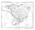
The Meierij van 's-Hertogenbosch was one of the four parts of the Duchy of Brabant, the others being the Margraviate of Antwerp, the County of Brussels and the County of Leuven/Louvain. Located in the current-day Netherlands, it acquired its name from the bailiff of 's-Hertogenbosch, who administered the area in the name of the Dukes of Brabant. The Meierij roughly corresponds to the larger province of North Brabant.

Vorden is a former municipality and a town in the eastern Netherlands, about 10 kilometres south-east of Zutphen. On 1 January 2005 the municipality merged with Hummelo en Keppel, Steenderen, Hengelo en Zelhem, to form the new municipality Bronckhorst.

Sint-Michielsgestel is a municipality in the southern part of the Netherlands. It is named for the village of Sint-Michielsgestel located within its boundaries.

Sint-Oedenrode is a town in the province of North Brabant.

Dilbeek is a municipality in the province of Flemish Brabant, in the Flemish region of Belgium. The municipality comprises the villages of Dilbeek proper, Groot-Bijgaarden, Itterbeek, Schepdaal, Sint-Martens-Bodegem, and Sint-Ulriks-Kapelle. Dilbeek is located just outside the Brussels-Capital Region, in the Pajottenland, hence the local name Poort van het Pajottenland. Even though Dilbeek is located in the Dutch language area of Belgium, there is a French-speaking minority represented by 3 members on the 35-seat local council. It is a mostly residential community with some preserved rural areas and some industrial zones.

Sint-Pieters-Leeuw is a municipality in the province of Flemish Brabant, in the Flemish region of Belgium.

Halle is a Belgian city and municipality in the Halle-Vilvoorde district (arrondissement) of the province of Flemish Brabant. It is located on the Brussels–Charleroi Canal and on the Flemish side of the language border that separates Flanders and Wallonia. Halle lies on the border between the Flemish plains to the North and the undulating Brabant lands to the South. The city also borders on the Pajottenland to the west. It is about 22 km (14 mi) southwest of Brussels. The official language of Halle is Dutch.

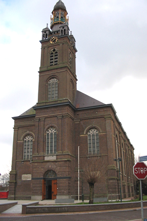
The Catholic Cathedral Church of St. John (Sint-Janskathedraal) of 's-Hertogenbosch, North Brabant, is the height of Gothic architecture in the Netherlands. It has an extensive and richly decorated interior, and serves as the cathedral for the bishopric of 's-Hertogenbosch.
Erp is a village in the southern Netherlands, in the province of North Brabant between 's-Hertogenbosch and Eindhoven. Prior to 1994, Erp was a municipality consisting of the town of Erp and the villages of Boerdonk and Keldonk. In that year, the municipality was merged with the municipality of Veghel to form one municipality under the latter name. The area of the former municipality of Erp has a population of 6,663, while Veghel has a population of 37,655.
Dinther is a village in the Dutch province of North Brabant. It is located in the municipality of Bernheze.
Kaatsheuvel is a town in the province of North Brabant, Netherlands situated along highways N261 and N628. With a population of roughly 16,600, it is the largest town in and the capital of the municipality of Loon op Zand, which also consists of the villages of De Moer and Loon op Zand.

Sint-Oedenrode is a moderately urbanized city and capital of the former municipality of the same name in the province of North Brabant. The city is located in the Meierij of 's-Hertogenbosch. Sint-Oedenrode counts 17,928 inhabitants and has an area of 64.25 km². The municipality has traditionally city rights since 1232, and was known as a "Vlek" in the past. Today it is still a large town. From southeast to northwest, the city is split by the river the Dommel.

The Jheronimus Bosch Art Center is located in the former New St. James Church on Jeroen Boschplein in 's-Hertogenbosch, the capital of North Brabant. Since 2007, there has been a permanent retrospective exhibition here on the life and work of the painter Jheronimus Bosch, who was born in the town. The venue is also used for concerts and conferences.
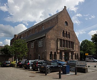
The Big Arsenal, in Dutch: Groot Tuighuis, in 's-Hertogenbosch, Netherlands, is also known as Old St. James Church, or Oude Sint Jacobskerk. It is the former location of the Noordbrabants Museum. It now houses the municipal heritage department and its storage. It is open to visitors four days a week.
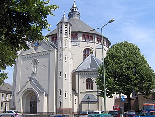
St. Catherine's Church, in Dutch Sint-Catharinakerk was previously named Cross Church, Kruiskerk or Kruisherenkerk and is located at the Kruisbroedershof.

The Great Church or Protestant Church is located in 's-Hertogenbosch. It is the main Protestant church of 's-Hertogenbosch.

Sint-Michielsgestel is a village in the municipality of Sint-Michielsgestel, Netherlands.