Den Dungen

Last updated
Den Dungen
Village
Den Dungen - Grinsel 84-86 - woonhuis.jpg
House in Den Dungen
Den Dungen vlag.svg
Den Dungen wapen.svg
2010-NL-P10-Noord-Brabant-positiekaart-gemnamen.jpg
Red pog.svg
Den Dungen
Location in the province of North Brabant in the Netherlands
Netherlands location map.svg
Red pog.svg
Den Dungen
Den Dungen (Netherlands)
Coordinates: 51°39′55″N5°22′17″E / 51.66528°N 5.37139°E / 51.66528; 5.37139
Country Netherlands
Province North Brabant
Municipality Sint-Michielsgestel
Area
[1]
  Total1.50 km2 (0.58 sq mi)
Elevation
[2]
6 m (20 ft)
Population
 (2021) [1]
  Total3,725
  Density2,500/km2 (6,400/sq mi)
Time zone UTC+1 (CET)
  Summer (DST) UTC+2 (CEST)
Postal code
5275 [1]
Dialing code 073
Major roadsA2 N279

Den Dungen is a village in the Dutch province of North Brabant. It is located in the municipality of Sint-Michielsgestel next to the village Maaskantje.

Contents

History

The village was first mentioned in 1300 as "Super Donghen prope Buscum", and means "sandy hills in swampy land". [3] Den Dungen developed in the Middle Ages on three hills near the Aa River. During the 17th century, a ring dike was built to protect against floods. [4]

The Catholic St.-Jacobus de Meerdere Church was completed in 1533. In 1899, a new tower was constructed with a needle spire. In 1927, the church was expanded. [4]

Den Dungen was home to 1,399 people in 1840. [5] Around 1900, Den Dungen and Maaskantje started to merge into a single urban area. [4] It was a separate municipality until 1996, when it was merged with Sint-Michielsgestel. [6]

Den Dungen is a twin town of Portishead, Somerset in England.

Related Research Articles

<span class="mw-page-title-main">Sint-Michielsgestel (municipality)</span> Municipality in North Brabant, Netherlands

Sint-Michielsgestel is a municipality in the southern part of the Netherlands. It is named for the village of Sint-Michielsgestel located within its boundaries.

<span class="mw-page-title-main">Houthem, Netherlands</span> Village in Limburg, Netherlands

Houthem is a village in the Dutch province of Limburg. It is a part of the municipality of Valkenburg aan de Geul, and lies about 8 km east of Maastricht.

<span class="mw-page-title-main">Berkel-Enschot</span> Town in North Brabant, Netherlands

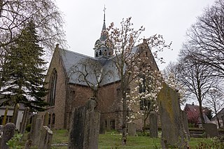
Berkel-Enschot is a Dutch village, located in the municipality of Tilburg in the North Brabant province which borders Belgium.

<span class="mw-page-title-main">Vierlingsbeek</span> Village in North Brabant, Netherlands

Vierlingsbeek is a village in the former municipality of Boxmeer in North Brabant province of the Netherlands. Until it was included in Boxmeer in 1998, it was a municipality of its own. Since 2022 it has been part of the new municipality of Land van Cuijk.

<span class="mw-page-title-main">Gemert</span> Town in North Brabant, Netherlands

Gemert is a town in the Dutch province of North Brabant. It is located in the municipality of Gemert-Bakel.

<span class="mw-page-title-main">Berghem</span> Town in North Brabant, Netherlands

Berghem is a town in the Dutch municipality of Oss. It is located about 4 km northeast of Oss itself.

<span class="mw-page-title-main">Sint Odiliënberg</span> Village in Limburg, Netherlands

Sint Odiliënberg is a village in southeast Netherlands, It is located in Roerdalen, Limburg, in the Roer River valley.

<span class="mw-page-title-main">Sint Jansteen</span> Village in Zeeland, Netherlands

Sint Jansteen is a village in the Dutch province of Zeeland. It is a part of the municipality of Hulst, and lies about 31 km southwest of Bergen op Zoom.

<span class="mw-page-title-main">Clinge</span> Village in Zeeland, Netherlands

Clinge is a village in the Dutch province of Zeeland. It is a part of the municipality of Hulst, and lies about 28 km southwest of Bergen op Zoom. Clinge is located on the Dutch-Belgian border and joins with the Belgian town of De Klinge, in the Belgian municipality of Sint-Gillis-Waas. This border can normally be crossed freely.

<span class="mw-page-title-main">Berlicum</span> Place in North Brabant, Netherlands

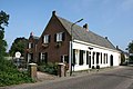
Berlicum is a town in the south of the Netherlands, located in North Brabant's Meierij region near the city of s-Hertogenbosch and the river Aa. The town was most likely founded between 600 and 700 AD. It was a municipality along with the village of Middelrode until a large-scale municipal reorganisation in 1996, when Berlicum and neighbouring Den Dungen merged with the municipality of Sint-Michielsgestel. In 2009, Berlicum had 9,743 inhabitants.

<span class="mw-page-title-main">Nieuwvliet</span> Village in Zeeland, Netherlands

Nieuwvliet is a village in the Dutch province of Zeeland. It is located about 5 km north of Oostburg, in the municipality of Sluis

<span class="mw-page-title-main">Sint Laurens</span> Village in Zeeland, Netherlands

Sint Laurens is a village in the Dutch province of Zeeland. It is located in the municipality of Middelburg, about 3 km north of the city.

<span class="mw-page-title-main">Sint Pancras</span> Village in North Holland, Netherlands

Sint Pancras is a town in the northwestern Netherlands. It is located in the municipality of Dijk en Waard, North Holland, about 5 km northeast of Alkmaar.

<span class="mw-page-title-main">Sint Annaparochie</span> Village in Friesland, Netherlands

Sint Annaparochie is a village in the municipality of Waadhoeke in Friesland, Netherlands. It lies approximately 15 km (9 mi) northwest of Leeuwarden and had approximately 4,830 inhabitants in 2021. The village is named after Saint Anne, the mother of Mary.

<span class="mw-page-title-main">Roggel</span> Village in Limburg, Netherlands

Roggel is a village in the Dutch province of Limburg. It is located in the municipality of Leudal.

<span class="mw-page-title-main">Sint Geertruid</span> Village in Limburg, Netherlands

Sint Geertruid is a village in the Dutch province of Limburg. It is located the municipality of Eijsden-Margraten.

<span class="mw-page-title-main">Oploo</span> Village in North Brabant, Netherlands

Oploo is a village in the Dutch province of North Brabant. It is located in the former municipality of Sint Anthonis. Since 2022 it has been part of the new municipality of Land van Cuijk.

<span class="mw-page-title-main">Udenhout</span> Town in North Brabant, Netherlands

Udenhout is a village and a former municipality in the Dutch province of North Brabant. It is located northeast of Tilburg, north of Berkel-Enschot and south of the National Parc Loonse en Drunense Duinen.

<span class="mw-page-title-main">Maaskantje</span> Village in North Brabant, Netherlands

Maaskantje is a village in the province of North Brabant, Netherlands. The village is part of the municipality of Sint-Michielsgestel, southeast of 's-Hertogenbosch.

<span class="mw-page-title-main">Sint-Michielsgestel</span> Place in North Brabant, Netherlands

Sint-Michielsgestel is a village in the municipality of Sint-Michielsgestel, Netherlands.

References

  1. 1 2 3 "Kerncijfers wijken en buurten 2021". Central Bureau of Statistics. Retrieved 18 April 2022.
  2. "Postcodetool for 5275AA". Actueel Hoogtebestand Nederland (in Dutch). Het Waterschapshuis. Retrieved 18 April 2022.
  3. "Den Dungen - (geografische naam)". Etymologiebank (in Dutch). Retrieved 18 April 2022.
  4. 1 2 3 Chris Kolman & Ronald Stenvert (1997). Den Dungen (in Dutch). Zwolle: Waanders. ISBN   90 400 9945 6 . Retrieved 16 April 2022.
  5. "Den Dungen". Plaatsengids (in Dutch). Retrieved 18 April 2022.
  6. Ad van der Meer and Onno Boonstra, Repertorium van Nederlandse gemeenten , KNAW, 2011.