Related Research Articles
Victoria is the smallest mainland state in Australia. As of 2008 it contained 2,850 separate protected areas with a total land area of 39,273 km2 (15,163 sq mi). Of these, 45 were national parks, totalling 28,023 km2 (10,820 sq mi).

The Kinglake National Park is a national park in Central Victoria, Australia. The 23,210-hectare (57,400-acre) national park is situated 50 kilometres (31 mi) northeast of Melbourne and includes tracks, and camping facilities.

Yarra Ranges National Park is located in the Central Highlands of Australia's southeastern state Victoria, 107 km northeast of Melbourne. Established in 1995 and managed by the statutory authority Parks Victoria, the park features a carbon-rich, temperate rainforest and a subalpine eucalypt forest on its northern plateau. It is home to large stands of mountain ash, the tallest tree species in Australia and among the tallest in the world. A wide diversity of fauna make their home across the park's 76,003 hectares, including kangaroos, wallabies, wombats, platypuses and 120 species of native birds. Among the conservation challenges facing Yarra Ranges National Park are climate change and invasive species of weeds.

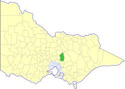
The Shire of Murrindindi is a local government area in the Hume region of Victoria, Australia, located in the north-east part of the state. It covers an area of 3,880 square kilometres (1,500 sq mi) and, in August 2021, had a population of 15,197. It includes the towns of Alexandra, Buxton, Eildon, Flowerdale, Kinglake, Marysville, Molesworth, Strath Creek, Taggerty, Yarck and Yea. It was formed in 1994 from the amalgamation of the Shire of Alexandra, Shire of Yea, and parts of the Shire of Broadford, Shire of Eltham, Shire of Euroa, Shire of Healesville and City of Whittlesea.

Devilbend Natural Features Reserve is a 1,005 ha natural reserve park in the rural locality of Tuerong on the Mornington Peninsula in central southern Victoria, Australia, 55 km (34 mi) southeast of the state capital Melbourne's city center.

The Plenty River is a perennial river of the Port Phillip catchment, located in the north-eastern Greater Melbourne region of the Australian state of Victoria.

The Shire of Eltham was a local government area about 25 kilometres (16 mi) northeast of Melbourne, the state capital of Victoria, Australia. The shire covered an area of 277.13 square kilometres (107.0 sq mi), and existed from 1856 until 1994.
The Shire of Yea was a local government area about 110 kilometres (68 mi) northeast of Melbourne, the state capital of Victoria, Australia. The shire covered an area of 1,392.32 square kilometres (537.6 sq mi), and existed from 1869 until 1994. The shire's population was dominated by the town of Yea.
Mount Disappointment is an 800-metre (2,600 ft) mountain located on the southern end of the Great Dividing Range, 9.5 kilometres (5.9 mi) north of Whittlesea and 60 kilometres (37 mi) north of Melbourne, the state capital of Victoria, Australia. It was named by explorers Hume and Hovell in 1824, and is now a popular hiking spot.
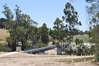
The North–South Pipeline, also known as the Sugarloaf Pipeline, is a water pipeline in Central Victoria, Australia, northeast of Melbourne that is part of Victoria's water system, acting as a link between Melbourne's water grid and the Murray-Goulburn water grid, supplying water via a series of existing and proposed pipelines. The 70-kilometre pipeline was connected to Melbourne in February 2010 to carry water from the Goulburn River to Melbourne's Sugarloaf Reservoir. It is the government's policy that it only be used in times of critical human need: when Melbourne's total water storages are less than 30% full on 30 November of any year. The pipeline can transfer a portion of Lake Eildon's water that is set aside for Melbourne, called the critical water reserve. This was 38,400 megalitres at 2 June 2014, and any changes are based on Goulburn-Murray Water's advice.
Angove River or Angove Creek is a river located in the Great Southern region of Western Australia most of the river is found within Two Peoples Bay Nature Reserve.
The Watts River is a perennial river of the Port Phillip and Western Port catchment, located in the Healesville area, in the Central region of the Australian state of Victoria.
The Organ Pipes National Park, abbreviated as OPNP, is a national park located in the Central region of Victoria, Australia. The 121-hectare (300-acre) protected area was established with the focus on conservation of the native flora and fauna, and preservation of the geological features in the Jacksons Creek, a part of the Maribyrnong valley, north-west of Melbourne. It is situated in a deep gorge in the grassy, basalt Keilor Plains.
Toorourrong Reservoir is a small water supply reservoir located on the southern slopes of the Great Dividing Range approximately 40 kilometres (25 mi) north of Melbourne, Victoria, Australia. The reservoir is formed by the Toorourrong Dam across the Plenty River, and an interbasin transfer. The dam is operated by Melbourne Water and the reservoir forms part of the Melbourne water supply system. Water from the Toorourrong Reservoir flows by aqueduct to the Yan Yean Reservoir.

The Central Gardens Nature Reserve, also called Central Gardens, is a protected nature reserve located in the western suburbs of Sydney, New South Wales, Australia. Established in 1976, the 12-hectare (30-acre) reserve, garden and fauna and wildlife park is situated in the suburb of Merrylands and is managed by Cumberland Council. The park is regionally important and it attracts visitors outside the Cumberland local government area. The bushland contains remnants of Cumberland Plain Woodland and is approximately 3.5 hectares.

The Bunurong Marine and Coastal Park collectively are a marine park and a coastal park located along the reef and coast of Harmers Haven, Cape Paterson and Inverloch in the South Gippsland region of Victoria, Australia. Collectively, the parks are located approximately 140 kilometres (87 mi) southeast of Melbourne, between Coal Point in the west to Wreck Creek in the east, and are used for walking, picnicking, boating, education and research.

The Dharawal National Park is a protected national park that is located in the Illawarra region of New South Wales, in eastern Australia. The 6,508-hectare (16,080-acre) national park is situated between the Illawarra Range and the Georges River and is approximately 45 kilometres (28 mi) south west of Sydney. There are three entry points to the park: from the east through Darkes Forest; from the north through Wedderburn; and from the south through Appin.
Hoddles Creek is a creek near Melbourne in Victoria, Australia.
The Mount Cole State Forest is in western Victoria, Australia, near the town of Beaufort. The forest is around Mount Cole, which formed 390 million years ago. The Indigenous Australians, the Beeripmo balug people, called it Bereep-bereep, which means wild. The forest covers an area of 12,150 hectares, including the forest around Mount Lonarch.

The Dandenong Valley Parklands are a collection of public parks and open space reserves along the Dandenong Creek, an urban creek in southeastern Melbourne, Victoria, Australia. The term refers only to the parklands along and in close proximity to the middle main stem of Dandenong Creek, stretching from Boronia Road in the north to Wellington Road in the south through the suburbs of Vermont South, Wantirna, Wantirna South and Wheelers Hill, even though there are a lot more parks and reserves along the extended catchment of the creek.
References
- ↑ Wallaby Creek designated water supply catchment area, Kinglake National Park, Management Plan (PDF), Parks Victoria, August 1998, ISBN 0-7311-3191-6, archived from the original (PDF) on 27 February 2011, retrieved 21 February 2011