Districts and neighbourhoods of Seville

Last updated

Map of Seville's districts Distritos Sevilla.svg
Map of Seville's districts

Seville, the capital of the region of Andalusia in Spain, has 11 districts, further divided into 108 neighbourhoods.

Contents


Casco Antiguo

Avenida de la Constitucion, one of the most important streets in the city. Avenida Constitucion 0092a.jpg
Avenida de la Constitución, one of the most important streets in the city.

The Casco Antiguo (Spanish: Ancient Shell) is the old quarter of Seville, in the centre of the city on the east bank of the Guadalquivir river. Principal tourist attractions are located here, such as the cathedral, the Alcázar, the Torre del Oro, the City Hall, the Palace of San Telmo, the Archivo General de Indias and the Metropol Parasol. Of its twelve neighbourhoods, El Arenal on the riverfront was the port of Seville until the Guadalquivir silted up in the 17th century, [1] while the neighbouring Santa Cruz neighbourhood was a Jewish quarter until the Spanish Inquisition. [2]

The University of Seville is mainly based in the former Royal Tobacco Factory in the south of the Casco Antiguo, the setting to the story and opera Carmen. The city's bullring is in El Arenal.

Neighbourhoods:

Distrito Sur

The former Mudejar Pavilion in the Parque de Maria Luisa is now used as the Museum of Arts and Traditions of Sevilla. Parque de Maria Luisa, Sevilla.jpg
The former Mudejar Pavilion in the Parque de Maria Luisa is now used as the Museum of Arts and Traditions of Sevilla.

The Distrito Sur (Spanish: South District) lies to the south of the Casco Antiguo on the east bank of the Guadalquivir. It was the location of most of the buildings during the Ibero-American Exposition of 1929: the Plaza de España, the Parque de María Luisa, Archeological Museum of Seville and the Museum of Arts and Traditions of Sevilla.

Neighbourhoods:

Triana

Betis Street (Triana) and Guadalquivir River Betis Sevilla.jpg
Betis Street (Triana) and Guadalquivir River

According to legend, Triana is named after the Roman Emperor Trajan, who was born in Italica, a Roman city north of modern Seville. Triana is known as a working-class and gypsy district. [3] It was a centre for the ceramics industry. [4] Like other districts that were historically split from the main city, Triana was known as an arrabal. The district is placed in a near-island position between two branches of the Guadalquivir west of the Casco Antiguo, narrowly linked to the mainland in the north.

This district has many historical buildings, such as the Santa Ana Church and the remains of the San Jorge Castle. The old quarter of the district offers a panoramic view of Seville's city centre. At the north of the district is the island of La Cartuja, a research and development park, site of Expo 92, from which some buildings were kept. The Isla Mágica amusement park is on the island, as is the 60,000-seater Estadio de La Cartuja, built for Seville's unsuccessful bids for the 2000 [5] and 2004 Summer Olympics. [6]

Neighbourhoods:

Macarena

The Andalusian Parliament meets in the Hospital de las Cinco Llagas in the Macarena. Parlamento Andaluz.JPG
The Andalusian Parliament meets in the Hospital de las Cinco Llagas in the Macarena.
Miraflores Park in Macarena District Parque Miraflores (Sevilla) - Aerial photograph.jpg
Miraflores Park in Macarena District

Macarena is the traditional and historical name of the area of Seville located north of the Casco Antiguo on the eastern bank of the Guadalquivir. Nowadays, La Macarena is the name of the neighborhood placed on both sides of the north city wall, but also a much bigger administrative district of Seville. Among other monuments, the Basilica of Nuestra Señora de la Esperanza Macarena, the Macarena Gate and the Parliament of Andalusia are in the district.

El Rinconcillo, a tapas bar built in the 1670s in the Macarena, is the oldest tapas bar in Seville and likely to be the oldest specifically-built tapas bar in the world. [7] The 45-metre-high Torre de Perdigones (Spanish: Tower of Pellets) has been converted into a Camera Obscura with views of the city centre and the Expo 92 site on the Isla de La Cartuja. [8]

Neighbourhoods:

Nervión

The Buhaira Gardens in Nervion Antiguos palacios de los Jardines de la Buhaira.jpg
The Buhaira Gardens in Nervión

Nervión is in the east of Seville. The district is an important commercial district of the city, where much of the regional capital's business takes place. It is the second focal point of the city, and is home to a number of important sites including Santa Justa, Seville's major train station, with high-speed links via the AVE to Madrid, Córdoba, and Cadiz.

The Estadio Ramón Sánchez Pizjuán is home to Sevilla FC, one of Seville's two football teams in the top flight of La Liga. The area's name is the origin of one of Sevilla FC's nicknames Los Nervionenses. [9] The Facultad de Ciencias Económicas y Empresariales (School of Business) of the University of Seville is in this district. [10]

Neighbourhoods:

Distrito Norte

The Alamillo Bridge links Distrito Norte to the Isla de La Cartuja in Triana. Puente del Alamillo by Pablo Perez 01.jpg
The Alamillo Bridge links Distrito Norte to the Isla de La Cartuja in Triana.

The Distrito Norte (Spanish: North District) occupies an area to the north of the Macarena on the east bank of the Guadalquivir. The Puente del Alamillo was built before Expo 92 to link across the river to the main Expo sites on the far north of the Isla de La Cartuja.

Neighbourhoods

Los Remedios

The main entrance to the Seville Fair 2012, in Los Remedios. Portada feria 2012.jpg
The main entrance to the Seville Fair 2012, in Los Remedios.

Los Remedios is located on the Isla de La Cartuja on the west bank of the Guadalquivir, to the south of Triana. It derives its name from a Carmelite convent of the same name found in that area. Before development in the latter half of the 20th century, this was one of the few standing structures in what is now Los Remedios. Seville's modern port is in the southern tip of this district, having moved south from the neighbourhood of El Arenal in the Casco Antiguo in the 17th century. Attractions: The Parque de los Príncipes, the Seville Fair, the Puente de San Telmo, the Museo de Carruajes, Los Remedios' tower and the Cuba Square.

Neighbourhoods

Este-Alcosa-Torreblanca

Convention centre in Este-Alcosa-Torreblanca Palacio de Congresos y Exposiciones (FIBES) Sevilla.jpg
Convention centre in Este-Alcosa-Torreblanca

Seville's international airport, San Pablo is in this district, which lies on the north bank of the Guadaira, a tributary of the Guadalquivir.

Neighbourhoods

Cerro-Amate

Seville Metro, La Plata station in Cerro-Amate. EstacionLaPlatadesdelacalle.JPG
Seville Metro, La Plata station in Cerro-Amate.

Attractions: Amate Park and Amate Sports Center.

Neighborhoods:

Bellavista-La Palmera

Palmas Altas Campus, Abengoa's headquarters, in Bellavista-La Palmera Palmasaltas-283.jpg
Palmas Altas Campus, Abengoa’s headquarters, in Bellavista-La Palmera

The majority of Bellavista-La Palmera lies in the far south of the city on the eastern bank of the Guadalquivir, opposite the Los Remedios district on the far south of the Isla de La Cartuja. The neighbourhood of Bellavista, lies on the eastern bank of the river Guadaira, a tributary which joins the Guadalquivir soon after. It was bought off the neighbouring city of Dos Hermanas.

Real Betis, a professional association football club, play in the Estadio Benito Villamarín in this district.

Neighbourhoods:

San Pablo-Santa Justa

Santa Justa Station in San Pablo-Santa Justa Estacion Santa Justa Acceso principal.jpg
Santa Justa Station in San Pablo-Santa Justa

Attractions: The Sports Palace of Seville and Kansas City Avenue.

Neighbourhoods:

Related Research Articles

<span class="mw-page-title-main">Seville</span> Capital and largest city of Andalusia and the province of Seville in Spain

Seville is the capital and largest city of the Spanish autonomous community of Andalusia and the province of Seville. It is situated on the lower reaches of the River Guadalquivir, in the southwest of the Iberian Peninsula.

<span class="mw-page-title-main">History of Seville</span> Aspect of Spanish history

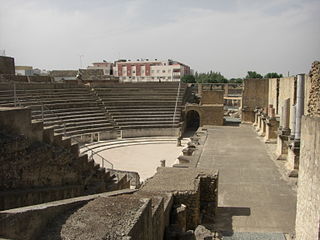
Seville has been one of the most important cities in the Iberian Peninsula since ancient times; the first settlers of the site have been identified with the Tartessian culture. The destruction of their settlement is attributed to the Carthaginians, giving way to the emergence of the Roman city of Hispalis, built very near the Roman colony of Itálica, which was only 9 km northwest of present-day Seville. Itálica, the birthplace of the Roman emperors Trajan and Hadrian, was founded in 206–205 BC. Itálica is well preserved and gives an impression of how Hispalis may have looked in the later Roman period. Its ruins are now an important tourist attraction. Under the rule of the Visigothic Kingdom, Hispalis housed the royal court on some occasions.

<span class="mw-page-title-main">Isla de La Cartuja</span>

Isla de la Cartuja is an island in the Guadalquivir River at Seville, Spain.

<span class="mw-page-title-main">Holy Week in Seville</span> Religious festival in Seville, Spain

Holy Week in Seville is one of two biggest annual festivals in Seville, Andalusia, Spain, the other being the Feria de Abril, which follows two weeks later. It is celebrated in the week leading up to Easter, and features the procession of pasos, floats of lifelike wooden sculptures of individual scenes of sorrowful Mysteries of the Rosary, or images of the grieving Virgin Mary.

<span class="mw-page-title-main">Macarena, Seville</span>

Macarena is one of the eleven districts into which the city of Seville, capital of the autonomous community of Andalucía, Spain, is divided for administrative purposes. It is located in the north of the city, bordered to the south by the Casco Antiguo and San Pablo-Santa Justa suburbs, to the east and north by Norte and to the west by Triana. It covers the area between the Guadalquivir River and the Carmona Highway and from the SE-30 ring-road in the north to the Ronda del Casco Antiguo. It contains smaller neighbourhoods such as León XIII, Miraflores, and the Polígono Norte as well as the Miraflores park along the SE-30. The district contains the Andalucian Parliament, the Torre de los Perdigones in the park of the same name, and the Hospital Universitario Virgen Macarena

Nervión is a district of Seville, Spain. It lies to the east of the city centre, to the north of the Distrito Sur, to the south of San Pablo-Santa Justa and to the west of Cerro-Amate.

<span class="mw-page-title-main">Triana, Seville</span>

Triana is a neighbourhood and administrative district on the west bank of the Guadalquivir River in the city of Seville, Spain. Like other neighborhoods that were historically separated from the main city, it was known as an arrabal. Triana is located on a peninsula between two branches of the Guadalquivir, narrowly linked to the mainland in the north. Two other districts are also usually included in this area, Los Remedios to the south and La Cartuja to the north.

<span class="mw-page-title-main">Los Remedios</span>

Los Remedios is a district of Seville, the regional capital of Andalusia, Spain. It is located on the Isla de La Cartuja, south of the district of Triana, between two forks of the Guadalquivir river. It is linked by bridge to the city centre and the districts of Distrito Sur and Bellavista-La Palmera. From the western side of the island, it is linked by road bridge to the city of San Juan de Aznalfarache and shares a boundary in the Guadalquivir with the city of Gelves. The southern tip of La Cartuja is opposite the municipality of Dos Hermanas.

<span class="mw-page-title-main">Alameda de Hércules</span>

The Alameda de Hércules , or simply La Alameda, is a garden square or mall in Seville, southern Spain. Built in 1574, it was originally a promenaded public garden, named after the eight rows of white poplar trees that fill its central part. Located in the northern half of the city's casco antiguo, between the Guadalquivir River and the Macarena neighbourhood, it was the oldest public garden in Spain and Europe.

<span class="mw-page-title-main">El Arenal, Seville</span> City neighborhood in Seville, Andalusia, Spain

El Arenal is a neighbourhood in the historical centre of Seville, the Casco Antiguo. It lies on the east bank of the Guadalquivir river to the west of the old Jewish Quarter, Santa Cruz, and south of the neighbourhoods of Museo and Alfalfa. Its name comes from the sandy nature that this east bank of the river once used to have. El Arenal has a history characterised by its former position as the port of Seville, until river silting forced the city to relocate the port to the southern edge of the city in the 17th century.

<span class="mw-page-title-main">Casco Antiguo</span>

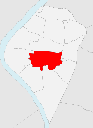
The Casco Antiguo is the city centre district of Seville, the capital of the Spanish region of Andalusia. The Casco Antiguo comprises Seville's old town, which lies on the east bank of the Guadalquivir river. It borders the districts of Macarena to the north, Nervión and San Pablo-Santa Justa to the east, and the Distrito Sur to the south. Bridges across the Guadalquivir link the Casco Antiguo to Los Remedios, Triana and La Cartuja.

<span class="mw-page-title-main">Gelves</span> City in Andalusia, Spain

Gelves is a city located in the province of Seville, in Andalusia, Spain. According to the 2006 census (INE), the city has a population of 8,325 inhabitants. It lies on the west bank of the Guadalquivir river.

<span class="mw-page-title-main">San Juan de Aznalfarache</span> City in Andalusia, Spain

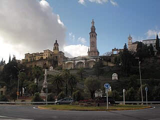
San Juan de Aznalfarache is a city located in the province of Seville, Spain. According to the 2006 census (INE), the city has a population of 20,121 inhabitants.

<span class="mw-page-title-main">Monastery of Santa Maria de las Cuevas</span>

The Monastery of Santa María de las Cuevas, also known as the Monastery of the Cartuja (Charterhouse), is a religious building on the Isla de La Cartuja in Seville, southern Spain. The Andalusian Contemporary Art Center (The Centro Andaluz de Arte Contemporáneo (CAAC)) is now located on this site.

<span class="mw-page-title-main">Walls of Seville</span> Defensive fortification in Seville, Spain

The Walls of Seville are a series of defensive walls surrounding the Old Town of Seville. The city has been surrounded by walls since the Roman period, and they were maintained and modified throughout the subsequent Visigoth, Islamic and finally Castilian periods. The walls remained intact until the 19th century, when they were partially demolished after the revolution of 1868. Some parts of the walls still exist, especially around the Alcázar of Seville and some curtain walls in the barrio de la Macarena.

<span class="mw-page-title-main">Bellavista-La Palmera</span>

Bellavista-La Palmera is a district of the city of Seville, the regional capital of the Spanish region of Andalusia. It is situated on the eastern bank of the Guadalquivir river, to the south of the city centre.

There are numerous sights and landmarks of Seville. The most important sights are the Alcázar, the Seville Cathedral, and the Archivo General de Indias, which are UNESCO World Heritage Sites.

Urban transports of Seville Municipal Corporation (TUSSAM) manages the bus service and urban trams in Seville, Spain.

<span class="mw-page-title-main">Avenida de la Constitución, Seville</span>

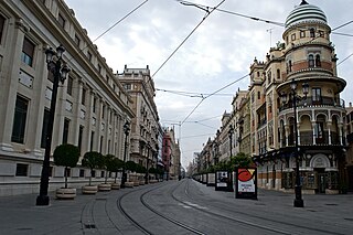
Avenida de la Constitución is an important avenue in the Casco Antiguo district of Seville, Andalusia, Spain. It starts from the square known as Puerta de Jerez and reaches the Plaza Nueva, considered the center of the city and where the historic building of the Seville City Council is located. It has a length of 600 m (0.37 mi).

<span class="mw-page-title-main">Alfalfa, Seville</span> City neighborhood in Seville, Andalusia, Spain

Alfalfa is a neighbourhood in the historical centre of Seville, the Casco Antiguo. It is located in the center of the district and bordered by Encarnación-Regina to the north, Santa Catalina and San Bartolomé to the east, Santa Cruz and El Arenal to the south and Museo to the west. In 2010, it had an estimated population of 4,197 inhabitants.

References

  1. "El Arenal, Sevilla".
  2. "Santa Cruz - Culture".
  3. "Triana, Sevilla".
  4. "Triana, Sevilla".
  5. "Olympic Games: 11 cities bid to stage 2004 Games". Independent.co.uk . 11 January 1996.
  6. "CNN/SI - Olympics - Seville seeking 2008 Olympic bid - Wednesday May 05, 1999 12:37 PM". Archived from the original on 9 March 2013. Retrieved 2 June 2012.
  7. "No etiquette in Seville's oldest tapas bar - Savoury Planet".
  8. "Cámara Oscura de la Torre de los Perdigones - Cámara Oscura". Archived from the original on 26 May 2011. Retrieved 3 June 2012.
  9. Roy, Shourin (21 August 2009). "Why do English clubs have such boring and redundant names?". SoccerBlog.com. Retrieved 15 September 2011.
  10. "Facultad de Ciencias Económicas y Empresariales - Universidad de Sevilla". Archived from the original on 21 June 2012. Retrieved 2 June 2012.