Djebel Serj

Last updated
View of Djebel Serj Parc national de Jebel Serj 8.jpg
View of Djebel Serj

The Djebel Serj (جبل السرج) is a limestone mountain located in the center of Tunisia, within the Tunisian ridge. It rises to 1,357 meters above sea level. The mountain is located at 35° 56′ 12″n, 9° 32′ 59″e

Limestone Sedimentary rocks made of calcium carbonate

Limestone is a carbonate sedimentary rock that is often composed of the skeletal fragments of marine organisms such as coral, foraminifera, and molluscs. Its major materials are the minerals calcite and aragonite, which are different crystal forms of calcium carbonate (CaCO3). A closely related rock is dolostone, which contains a high percentage of the mineral dolomite, CaMg(CO3)2. In fact, in old USGS publications, dolostone was referred to as magnesian limestone, a term now reserved for magnesium-deficient dolostones or magnesium-rich limestones.

Mountain A large landform that rises fairly steeply above the surrounding land over a limited area

A mountain is a large landform that rises above the surrounding land in a limited area, usually in the form of a peak. A mountain is generally steeper than a hill. Mountains are formed through tectonic forces or volcanism. These forces can locally raise the surface of the earth. Mountains erode slowly through the action of rivers, weather conditions, and glaciers. A few mountains are isolated summits, but most occur in huge mountain ranges.

Sea level Average level for the surface of the ocean at any given geographical position on the planetary surface

Mean sea level (MSL) is an average level of the surface of one or more of Earth's oceans from which heights such as elevation may be measured. MSL is a type of vertical datum – a standardised geodetic datum – that is used, for example, as a chart datum in cartography and marine navigation, or, in aviation, as the standard sea level at which atmospheric pressure is measured to calibrate altitude and, consequently, aircraft flight levels. A common and relatively straightforward mean sea-level standard is the midpoint between a mean low and mean high tide at a particular location.

Contents

Location

Djebel Serj is located twenty kilometers southeast of Siliana and sixty kilometers north-west of Kairouan, in the middle of the ridge, halfway between Grombalia and djebel Tamsmida. It is about five kilometers wide and twenty kilometers long.

Siliana Place in Siliana Governorate, Tunisia

Siliana is a modern farming town in northern Tunisia. It is located at around 36°4′55″N9°22′29″E, 130 km south-west of the capital Tunis. It is the capital of the Siliana Governorate. It is located 4 miles away from Jama where the Battle of Zama occurred.

Kairouan City in Tunisia

Kairouan, is the capital of the Kairouan Governorate in Tunisia. It is a UNESCO World Heritage site. The city was founded by the Umayyads around 670. In the period of Caliph Mu'awiya, it became an important centre for Sunni Islamic scholarship and Quranic learning, and thus attracting a large number of Muslims from various parts of the world, next only to Mecca and Medina. The holy Mosque of Uqba is situated in the city.

Grombalia in Nabeul Governorate, Tunisia

Grombalia is a Tunisian city located in the Nabeul Governorate. Its population was 24,336, while the population of the municipality was 67,475. It is the birthplace of former president Moncef Marzouki.

Its northern slope represents the watershed of the main wadis that feed the Lakhmess dam.

Drainage divide Elevated terrain that separates neighbouring drainage basins

A drainage divide, water divide, divide, ridgeline,, watershed, water parting or height of land is elevated terrain that separates neighbouring drainage basins. On rugged land, the divide lies along topographical ridges, and may be in the form of a single range of hills or mountains, known as a dividing range. On flat terrain, especially where the ground is marshy, the divide may be harder to discern.

Name

The origin of the appellation serj would come from the peculiar shape of a mountain ridge which approaches the shape of a saddle (Arabic: سرج). This rapprochement has fed many legends and myths around the formation of this singularity among the neighboring populations of the jebel.

Saddle supportive structure for a rider or other load, fastened to an animals back by a girth

The saddle is a supportive structure for a rider or other load, fastened to an animal's back by a girth. The most common type is the equestrian saddle designed for a horse. However, specialized saddles have been created for oxen, camels and other creatures. It is not known precisely when riders first began to use some sort of padding or protection, but a blanket attached by some form of surcingle or girth was probably the first "saddle", followed later by more elaborate padded designs. The solid saddle tree was a later invention, and though early stirrup designs predated the invention of the solid tree. The paired stirrup, which attached to the tree, was the last element of the saddle to reach the basic form that is still used today. Today, modern saddles come in a wide variety of styles, each designed for a specific equestrianism discipline, and require careful fit to both the rider and the horse. Proper saddle care can extend the useful life of a saddle, often for decades. The saddle was a crucial step in the increased use of domesticated animals, during the Classical Era.

Arabic Central Semitic language

Arabic is a Central Semitic language that first emerged in Iron Age northwestern Arabia and is now the lingua franca of the Arab world. It is named after the Arabs, a term initially used to describe peoples living in the area bounded by Mesopotamia in the east and the Anti-Lebanon mountains in the west, in northwestern Arabia, and in the Sinai Peninsula. Arabic is classified as a macrolanguage comprising 30 modern varieties, including its standard form, Modern Standard Arabic, which is derived from Classical Arabic.

Description

Djebel Serj panorama. Djebel Serj vue panoramique.jpg
Djebel Serj panorama.

The mountain is in the Jebel Serj National Park.

This mountain is considered a special place for speleology in Tunisia due to the Ain Dhab and Mine caves being in the mountain.

Caving in Tunisia is a relatively rare sport in the country. Caving emerged in the late 1970s and includes a limited number of practitioners. Tunisia has a number of sites suitable for the sport.

The mountain has been protected within the Jebel Serj national park since the decree of March 29, 2010. [1] This one has an area of 17.2 km2

National park park used for conservation purposes of animal life and plants

A national park is a park in use for conservation purposes. Often it is a reserve of natural, semi-natural, or developed land that a sovereign state declares or owns. Although individual nations designate their own national parks differently, there is a common idea: the conservation of 'wild nature' for posterity and as a symbol of national pride. An international organization, the International Union for Conservation of Nature (IUCN), and its World Commission on Protected Areas (WCPA), has defined "National Park" as its Category II type of protected areas.

Recent history

In November 2015, a raid operation was carried out at the Jebel Serj in the context of the fight against terrorism, without, however, leading to an arrest. [2] A similar operation in January 2016 led to the death of an alleged terrorist. [3]

The mountain is also affected by several fires in July 2016 in different areas. [4]

Related Research Articles

Kairouan Governorate Governorate in Tunisia

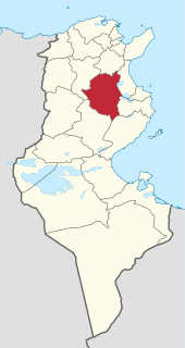
Kairouan Governorate is one of the twenty-four governorates of Tunisia. It is landlocked and in the centre-east of the country. It covers an area of 6,712 km² and has a population of 570,559. The narrower province of Sousse borders it to the east, the nearest coastline The capital is Kairouan. Lowland parts of the province are semi-arid, experiencing in most years light rains in the winter months and scant rainfall in other months but higher parts attract relief precipitation in and around the Djebel Zhagdoud and a large part of the Djebel Serj national parks, in the north-east of the province which are geologically outcrops of the Dorsal Atlas mountains in the province to the north.

Siliana Governorate Governorate in Tunisia

Siliana Governorate is one of the twenty-four governorates (provinces) of Tunisia, is landlocked and is in the north of the country. It covers an area of 4,631 km² and has a population of 223,087 (2014 census). The capital is Siliana.

Delegations of Tunisia administrative division of Tunisia

The delegations of Tunisia (mutamadiyah) are the second level administrative divisions of Tunisia between the governorates and the sectors (imadats). As of 2006 there were 24 governorates which were divided into 264 delegations (mutamadiyat) and further divided into 2073 sectors. The delegations are listed below, organized by governorate.

El Fahs Tunisian town

El Fahs is a town and commune located in the Zaghouan Governorate, 60 kilometers south-west of Tunis, Tunisia. Its population in 2014 was 23,561.

Aïn Djeloula Commune and town in Kairouan Governorate, Tunisia

Aïn Djeloula is a small town and commune in the Kairouan Governorate of central Tunisia, situated 30 kilometers west of Kairouan and the eastern mountains of Jebel Ousselat. In 2004 it had a population of 1,651.

Ras Jebel Commune and town in Bizerte Governorate, Tunisia

Ras Jebel, also known as Ras el-Djebel, is a town, commune, and archaeological site on Cap Sidi in the Bizerte Governorate of Tunisia. The name of the city refers to the summit or end of the mountain, thus evoking the end of the Atlas Mountains.

Oueslatia Commune and town in Kairouan Governorate, Tunisia

Oueslatia is a town and commune in the Kairouan Governorate, Tunisia. As of 2004 it had a population of 8,444. It is also the capital of a delegation with 36,195 inhabitants in the 2006 census.

Mezzouna is a town and commune in the Sidi Bou Zid Governorate, Tunisia. As of 2004 it had a population of 6,101.

Kesra Commune and town in Siliana Governorate, Tunisia

Kesra is a town and commune in the Siliana Governorate, Tunisia. As of 2004 it had a population of 2,490. In 2014 this was 2600. Kesra is in Siliana Governorate near Maktar at 35.8N and 9.36e. The town is at altitude of 966m and is near the Jebel Serj national park. During the Roman Empire Kesra was a civitas of the Roman Province of Byzacena called Cusira.

Gaâfour Commune and town in Siliana Governorate, Tunisia

Gaâfour is a town and commune in the Siliana Governorate, north-western Tunisia, located 120 kilometers southwest of Tunis. It is attached to Siliana. As of 2004 it had a population of 9,358 people. The town has a station located on the railway linking Tunis to Kalaat Khasba.

Téboulba Tunisian town

Téboulba is a town in the Sahel region of Tunisia. It is located about 25 kilometers south of Monastir. It is part of the administrative governorate of Monastir, and is the county seat of the Delegation with the same name, which has a population of 37,485 people.

North West Tunisia

North West Tunisia or in is one of the six geographic and economic regions of Tunisia, it consists of four governorates : Béja, Kef, Siliana and Jendouba. The region had a population of 1,170,752 representing 12.2% of the total population of Tunisia. This makes it the 5th-most populous region in the country, with only South West Tunisia being smaller.

Urusi was a civitas and ancient episcopal see of the Roman province of Africa Proconsularis in present-day Tunisia.

Jebel Serj National Park national park of Tunisia

The Jebel Serj National Park is a Tunisian national park situated between the delegation of South Siliana in the Siliana Governorate and the delegation of the Oueslatia in the Kairouan Governorate. This park of 6.64 sq mi was established on 29 March 2010 and it's managed by the Tunisian Ministry of Agriculture.

Jebel Chitana-Cap Négro National Park

Jebel Chitana-Cap Negro national Park is a national park situated on the north coast of Tunisia, between the cap Serrat and the Sidi el Barrak Dam. It consists by the forest chain of Jebel Chitana, within forest district of Bizerte, and that of Bellif, dependent on the forest district of Béja.

Djebel Bargou mountain in Tunisia

Jebel Bargou is a mountain (Jebel) of Tunisia, which rises to 1266m altitude.

El Oued Siliana is a river of Tunisia in the region arising from Marktar, which runs north and drains into the river Medjerda about 5km west of Testour.

Henchir-Guennara is a locality and Archaeological site in Tunisia 53.5km southwest of Tunis,

Chaîne du Thaljah mountain in Tunisia

The Chaîne du Thaljah is a range of mountains in the Gafsa Governorate of Tunisia. Huge deposits of phosphates were found at the base of the chain on 1885.

Central West Tunisia or in is the region located at the Central West of Tunisia which assembles Three of the following states: Sidi Bouzid, Kairouan and Kasserine.

References

  1. Décret du 29 mars 2010, relatif à la création d'un parc national à « Jebel Serj » du gouvernorat de Siliana et du gouvernorat de Kairouan », Journal officiel de la République tunisienne, no 27, 2 avril 2010, p. 900-902
  2. tuniscope.com, 19 octobre 2016
  3. 4 janvier 2016 kapitalis.com.
  4. deux incendies déclenchés au Djebel Serj.

Coordinates: 35°56′12″N9°32′59″E / 35.9367°N 9.5497°E / 35.9367; 9.5497