Dodesheide

Last updated

Dodesheide is a town in the borough of Osnabrück, Germany; with a population of roughly 7,900 residents it is located to the north-east of the city. Its boundaries are delineated in the north by the Vehrter Landstraße, in the west by the landwehr – a former defensive line around the town consisting of a bank and ditches – in the south by the Sandbach and the Osnabrück-Bremen railway line; the city boundary itself marks its eastern border. It is made up of sections of the former districts of Schinkel and Haste.

Osnabrück Place in Lower Saxony, Germany

Osnabrück is a city in the federal state of Lower Saxony in north-west Germany. It is situated in a valley penned between the Wiehen Hills and the northern tip of the Teutoburg Forest. With a population of 168,145 Osnabrück is one of the four largest cities in Lower Saxony. The city is the centrepoint of the Osnabrück Land region as well as the District of Osnabrück.

Germany Federal parliamentary republic in central-western Europe

Germany, officially the Federal Republic of Germany, is a country in Central and Western Europe, lying between the Baltic and North Seas to the north, and the Alps to the south. It borders Denmark to the north, Poland and the Czech Republic to the east, Austria and Switzerland to the south, France to the southwest, and Luxembourg, Belgium and the Netherlands to the west.

Landwehr (border) border demarcations or border defences and enclosures in Central Europe

The terms landwehr, landgraben and landhege refer to border demarcations or border defences and enclosures in Central Europe that were either built by settlements with the right of enclosure or to mark and defend entire territories. These measures, usually comprising earthworks or dykes as well as ditches and impenetrable lines of hedging, for protecting towns and villages date mainly to the High and Late Middle Ages and consist, in some cases, of systems over a hundred kilometres long. Comparable earthworks have been recorded since Antiquity. The Roman limes are the best known examples of earlier landwehrs. The Danewerk is another example of this type of barrier.

Haus Gartlage (Gartlage House) Osnabruck Haus Gartlage.jpg
Haus Gartlage (Gartlage House)

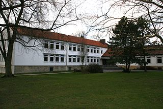
The district’s most significant building is the Haus Gartlage, a former Jesuit seat which some years ago was converted into residences. Apart from this and a number of farms, most of the developments in the Dodesheide district are from the 20th century. Since the 1950s, the construction of residential space following set construction stages has been systematically encouraged; one notable case is the “Dodeshaus” model building project from the 1960s, focused on the area between Haster Weg and Ellerstraße where primarily bungalows are situated. The eastern part of the district continues to be characterised by the barracks of the British army and the attached soldiers’ residences; their final withdrawal in 2009 led to expectations of extensive structural change in the area.

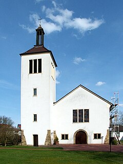
There are two churches in Dodesheide: the Thomaskirche (Protestant) and the St. Franziskus Church (Catholic).

The former Reformed Protestant Erloserkirche (Church of the Redeemer); used since 2010 by the parish of the Holy Mother Mary of the Greek Orthodox Church in Osnabruck and Munster Ehemalige Erloserkirche Dodesheide.jpg
The former Reformed Protestant Erlöserkirche (Church of the Redeemer); used since 2010 by the parish of the Holy Mother Mary of the Greek Orthodox Church in Osnabrück and Münster

At the beginning of the 1970s, the possibility of making Dodesheide the location of the planned University of Osnabrück was discussed; in the end, however, the district of Westerberg was chosen. Its main offices are located at the Schloss Osnabrück (Osnabrück Palace). A remnant of the planning from that time remains in the form of the Dodesheide student residence located on Mecklenburger Straße; with 206 residents it is today the second largest student residence in the town. [1]

Westerberg (Osnabrück district) human settlement in Germany

Westerberg is a district of Osnabrück, Lower Saxony, Germany, with roughly 8,700 residents. It is situated in the west of the city between Lotter Straße and Pagenstecherstraße. The districts bordering it are Eversburg, Hafen, Sonnenhügel, Innenstadt, Weststadt, Hellern and Atter. The border with Atter passes through the Rubbenbruchsee, part of a large local recreation area.

The traditional perception of the name Dodesheide as linked to “Todesheide” (Death’s Heath) is most likely false. The name is assumed to derive from the Old German proper name “Dodo”: its proper meaning being “Dodos Heide” (Dodo’s Heath).

Related Research Articles

The Osnabrück Canal or SKO, is an artificial waterway, about 14.5 kilometres (9 mi) long, that links the Mittelland Canal in central Germany with the port in the town of Osnabrück. It was built between 1910 and 1915 and runs largely parallel to the unnavigable River Hase, the greatest distance between the two being about 1 kilometre (0.6 mi).

Köllnischer Park Public park near the River Spree in Mitte, Berlin, Germany

Köllnischer Park is a public park located near the River Spree in Mitte, Berlin. It is named after Cölln, one of the two cities which came together to form Berlin; the park location was originally just outside it. Approximately 1 hectare in area, the park came into existence in the 18th and 19th centuries on the site of fortifications. It was redesigned as a public park in 1869–73 and was further modified in the 20th century with the addition of first a bear enclosure, the Bärenzwinger, and later a permanent exhibition of sculpture, the Lapidary. The park is a registered Berlin landmark.

Widukindland human settlement in Germany

Widukindland is a district of Osnabrück, Germany. It is situated in the north-east of the city, on the slopes of the Schinkelberg. It arose from the former boundaries of Schinkel.

Schinkel is a district of Osnabrück, Germany, first mentioned in records in 1332. It is situated in the east of the city, into which it was incorporated on 1 April 1914. There are roughly 13,300 people in Schinkel.

Schinkel-Ost is a district of Osnabrück, Germany. It originally lay within the former boundaries of Schinkel, which was incorporated into Osnabrück in 1914. Schinkel-Ost is home to roughly 3,500 residents. The evangelical Jakobuskirche, Catholic Rosenkranzkirche, “Blau-Weiß” (blue-white) sports team, Diesterwegschule and the Gesamtschule Schinkel are located in this district.

Schölerberg human settlement in Germany

Schölerberg is a district of Osnabrück, Germany, with approximately 13,900 residents.

Wüste is a district of the city of Osnabrück, Lower Saxony, Germany. With almost 14,000 residents it is the most populous district of Osnabruck. It is made up of the two subdivisions “Vordere Wüste” and “Hintere Wüste”. Its central location and good infrastructure make it an appealing residential area.

Weststadt (Osnabrück district) human settlement in Germany

Weststadt is a district of the city of Osnabrück with around 9,000 residents. It is located to the west of the Innenstadt district, on which it borders along with the districts of Westerberg, Wüste and Hellern.

Hafen (Osnabrück) human settlement in Germany

Hafen (Harbour) is a district of Osnabrück, Lower Saxony. Germany. It is located in the north-west of the city and had a population of roughly 2,358 residents in 1,454 households as of late 2008. One year earlier the city had 2,372 residents. It covers an area of 407.2 hectares.

Sonnenhügel is a district of Osnabrück, Germany, located over the northern border of the Innenstadt district.

Hellern human settlement in Germany

Hellern is a district of Osnabrück with roughly 6,800 residents, located on the western and south-western borders of the city. It is bordered by the Atter, Westernerg, Weststadt, Wüste and Sutthausen districts; on its west and south-west it borders on the municipality of Lotte in North Rhine-Westphalia and also Hasbergen in the surrounding district of Osnabrück. Hellern is located in the valley of the small Düte river.

Gartlage human settlement in Germany

Gartlage is a district of the city of Osnabrück, Lower Saxony, Germany. It is situated next to the Innenstadt.

Fledder human settlement in Germany

Fledder is a district in the east of Osnabrück, Germany, characterised by its large prevalence of industrial estates. Despite being the location of numerous businesses and large supermarkets the district has comparatively few residential buildings; its population is roughly 2,400.

Kalkhügel human settlement in Germany

Kalkhügel is a district of Osnabrück, Germany with a population of roughly 5,900 residents. It is home to both a Protestant and a Catholic church. There is also a school centre (Schulzentrum) located in the district.

Haste is a district in the north-east of Osnabrück, Germany. It is the fifth-largest district in the city on the River Hase, with a total land area of 788.8 hectares. Currently it has a population of about 6,600.

Sutthausen is a district of Osnabrück, Germany, with a population of about 4,500 residents. It is located in the south of the city, close to the Teutoburg Forest; it originally arose from two separate estates, Gut Sutthausen and Gut Wulften. The district has both Protestant and Catholic churches - respectively the Apostelkirche and the Marienkirche.

Atter (Osnabrück) human settlement in Germany

Atter is a district in the west of Osnabrück, Lower Saxony, Germany, with a population of 4,135 residents across 2,030 households. Covering an area of 1,075.9 hectares, it was incorporated into the city of Osnabrück on 1 July 1972. The districts on which it borders are Eversburg (NE), Westerberg (SE), and Hellern (S). On the west it borders on the municipality of Lotte in North Rhine-Westphalia; Autobahn 1 also passes through this area. The border with Westerberg runs through the Rubbenbruchsee, a local recreation area.

Voxtrup is a district in the south-east of Osnabrück, Germany, with a population of roughly 7,000 residents. It is home to the Evangelical Margaretenkirche and the Catholic St. Antonius Kirche.

Nahne is a district in the south of Osnabrück, Germany with a population of 2,241 residents, thus making it the city’s smallest district in terms of population. It covers an area of 4.854 km2.

References

  1. Wohnheim Dodesheide: Kurz-Info (last accessed 10 July 2012)

Coordinates: 52°18′14″N8°04′22″E / 52.3039°N 8.0728°E / 52.3039; 8.0728

Geographic coordinate system Coordinate system

A geographic coordinate system is a coordinate system that enables every location on Earth to be specified by a set of numbers, letters or symbols. The coordinates are often chosen such that one of the numbers represents a vertical position and two or three of the numbers represent a horizontal position; alternatively, a geographic position may be expressed in a combined three-dimensional Cartesian vector. A common choice of coordinates is latitude, longitude and elevation. To specify a location on a plane requires a map projection.