Schwenksville is a borough in Montgomery County, Pennsylvania, United States. The population was 1,431 at the 2020 census. It is notable for being located near the site of the Philadelphia Folk Festival. The borough was founded in 1684, when the Lenni-Lenape Indians ceded to William Penn the land along the Perkiomen Creek; it was incorporated in 1903. The borough was named for George Schwenk, whose son, Jacob Schwenk, served in George Washington's army.

Turkey Run State Park, Indiana's second state park, is in Parke County in the west-central part of the state along State Road 47, 2 miles (3.2 km) east of U.S. 41.

Oakleigh is a suburb in Melbourne, Victoria, Australia 14 km south-east of Melbourne's Central Business District, located within the City of Monash local government area. Oakleigh recorded a population of 8,442 at the 2021 census.

Brandywine Creek is a tributary of the Christina River in southeastern Pennsylvania and northern Delaware in the United States. The Lower Brandywine is 20.4 miles (32.8 km) long and is a designated Pennsylvania Scenic River with several tributary streams. The East Branch and West Branch of the creek originate within 2 miles (3 km) of each other on the slopes of Welsh Mountain in Honey Brook Township, Pennsylvania, about 20 miles (32 km) northwest of their confluence.
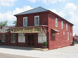
Bridgeton is an unincorporated community in Raccoon Township, Parke County, in the U.S. state of Indiana. It is notable for its covered bridge, which was destroyed on April 28, 2005, by a fire set by an arsonist. A historically accurate reconstruction of the bridge was completed in October, 2006.
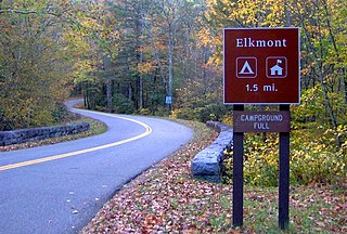
Elkmont is a region situated in the upper Little River Valley of the Great Smoky Mountains of Sevier County, in the U.S. state of Tennessee. Throughout its history, the valley has been home to a pioneer Appalachian community, a logging town, and a resort community. Today, Elkmont is home to a large campground, ranger station, and historic district maintained by the Great Smoky Mountains National Park.
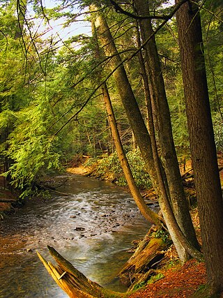
Cook Forest State Park is a 8,500-acre (3,440 ha) Pennsylvania state park in Farmington Township, Clarion County, Barnett Township, Forest County and Barnett Township, Jefferson County, Pennsylvania in the United States. Located just south of the Allegheny National Forest, the park is a heavily wooded area of rolling hills and mountains along the Clarion River in northwestern Pennsylvania. Cook Forest State Park is known for some of America's finest virgin white pine and hemlock timber stands and was once called the "Black Forest" due to the preponderance of evergreen tree coverage.

Poquessing Creek is a 10.3-mile-long (16.6 km) creek, a right tributary of the Delaware River, that forms the boundary between Philadelphia and Bensalem Township, which borders it to the northeast along the Delaware. It has defined this boundary between Bucks and Philadelphia counties since 1682.
Paynes Creek Historic State Park is a Florida State Park located on Lake Branch Road one-half mile southeast of Bowling Green, Florida. On November 21, 1978, it was added to the United States National Register of Historic Places, under the title of Payne's Creek Massacre-Fort Chokonikla Site.

Ridley Creek State Park is a 2,606-acre (1,055 ha) Pennsylvania state park in Edgmont, Middletown, and Upper Providence Townships, Delaware County, Pennsylvania in the United States. The park, about 5 miles (8 km) north of the county seat of Media, offers many recreational activities, such as hiking, biking, fishing, and picnicking. Ridley Creek passes through the park. Highlights include a 5-mile (8 km) paved multi-use trail, a formal garden designed by the Olmsted Brothers, and Colonial Pennsylvania Plantation, which recreates daily life on a pre-Revolutionary farm. The park is adjacent to the John J. Tyler Arboretum. Ridley Creek State Park is just over 16 miles (26 km) from downtown, Philadelphia between Pennsylvania Route 352 and Pennsylvania Route 252 on Gradyville Road.

Larrys Creek is a 22.9-mile-long (36.9 km) tributary of the West Branch Susquehanna River in Lycoming County in the U.S. state of Pennsylvania. A part of the Chesapeake Bay drainage basin, its watershed drains 89.1 square miles (231 km2) in six townships and a borough. The creek flows south from the dissected Allegheny Plateau to the Ridge-and-valley Appalachians through sandstone, limestone, and shale from the Devonian, Mississippian, and Pennsylvanian periods.

Pittstown is an unincorporated community located at the intersection of the boundaries of Alexandria, Franklin and Union townships in Hunterdon County, New Jersey. The area is named after William Pitt. The area is served as United States Postal Service ZIP Code 08867. The area was named Hofftown in the 18th century after landowner Lawrence Hoff. The Pittstown Historic District was listed on the state and national registers of historic places in 1990.

Imlaystown is an unincorporated community located along County Route 43 and Davis Station Road within Upper Freehold Township in Monmouth County in the U.S. state of New Jersey. It is located in ZIP code 08526. The community is accessible from Exit 11 of Interstate 195.

Huntingdon Valley is a village, as well as a suburban mailing address located in Lower Moreland Township, Upper Moreland Township and Abington Township all in Montgomery County, and in small sections of Upper Southampton Township and Lower Southampton Township in Bucks County, Pennsylvania, United States, bordering the Fox Chase section of Philadelphia County.

Mogollon, also called the Mogollon Historic District, is a former mining town located in the Mogollon Mountains in Catron County, New Mexico, United States. Located east of Glenwood and Alma, it was founded in the 1880s at the bottom of Silver Creek Canyon to support the gold and silver mines in the surrounding mountains. The "Little Fannie" mine became the most important employer for the town. During the 1890s, Mogollon had a transient population of between 3,000 and 6,000 miners. Because of its isolation, it had a reputation as one of the wildest mining towns in the West. Today Mogollon is listed as Fannie Hill Mill and Company Town Historic District on the National Register of Historic Places.

The Beeson Covered Bridge originally crossed Roaring Creek, one mile (1.6 km) northwest of Marshall, Indiana, on County Road 216, in Washington Township, Parke County. The bridge was moved to its current location in Billie Creek Village in December 1979.

George Washington's Gristmill was part of the original Mount Vernon plantation, constructed during the lifetime of the United States' first president. The original structure was destroyed about 1850. The Commonwealth of Virginia and the Mount Vernon Ladies’ Association have reconstructed the gristmill and the adjacent distillery. The reconstructed buildings are located at their original site three miles (4.8 km) west of the Mount Vernon mansion near Woodlawn Plantation in the Mont Vernon area of Fairfax County. Because the reconstructed buildings embody the distinctive characteristics of late eighteenth century methods of production and are of importance to the history of Virginia, the site is listed on the National Register of Historic Places despite the fact that the buildings are not original.
St. Joe Minerals Corporation was an American mining company. It was the United States largest producer of lead and zinc at the time of its merger with Fluor Corporation in 1981. The St. Joseph Lead Company was founded on March 25, 1864 by Lyman W. Gilbert, John E. Wylie, Edmund I. Wade, Wilmot Williams, James L. Dunham and James L. Hathaway in New York City.

The Whitehouse–Mechanicsville Historic District is a historic district located along old New Jersey Route 28, Mill, Lamington and School Roads in Whitehouse and Mechanicsville, unincorporated communities in Readington Township, Hunterdon County, New Jersey. It was added to the National Register of Historic Places on March 17, 2015 for its significance in architecture and community development. The district includes 140 contributing buildings.