
Gueydan is a town in Vermilion Parish, Louisiana, United States. The population was 1,398 at the 2010 census, down from 1,598 in 2000. At the 2020 population estimates program, its population decreased to 1,328. It is part of the Abbeville micropolitan statistical area.

The Burdekin River is a river in North and Far North Queensland, Australia. The river rises on the northern slopes of Boulder Mountain at Valley of Lagoons, part of the western slope of the Seaview Range, and flows into the Coral Sea at Upstart Bay over 200 kilometres (124 mi) to the southeast of the source, with a catchment area of approximately 130,000 square kilometres (50,000 sq mi). The Burdekin River is Australia's largest river by (peak) discharge volume.

Mbale District is a district in Eastern Uganda. It is named after the largest city in the district, Mbale, which also serves as the main administrative and commercial center in the sub-region.

A paddy field is a flooded field of arable land used for growing semiaquatic crops, most notably rice and taro. It originates from the Neolithic rice-farming cultures of the Yangtze River basin in southern China, associated with pre-Austronesian and Hmong-Mien cultures. It was spread in prehistoric times by the expansion of Austronesian peoples to Island Southeast Asia, Madagascar, Melanesia, Micronesia, and Polynesia. The technology was also acquired by other cultures in mainland Asia for rice farming, spreading to East Asia, Mainland Southeast Asia, and South Asia.
Richvale is a small census-designated place in Butte County, California, US, south of Chico and west of Oroville. The primary crop grown in the area surrounding Richvale is rice, irrigated from the Oroville Dam on the Feather River. Several farmers in the area are known for organic farming. The population was 244 at the 2010 census.

Vembanad is the longest lake in India, as well as the largest in the state of Kerala. The lake has an area of 230 square kilometers and a maximum length of 96.5 km.
Tororo District is a district in the Eastern Region of Uganda. The town of Tororo serves as the district headquarters.

The Yolo Bypass is one of the two flood bypasses in California's Sacramento Valley located in Yolo and Solano Counties. Through a system of weirs, the bypass diverts floodwaters from the Sacramento River away from the state's capital city of Sacramento and other nearby riverside communities.

The Riverland is a region of South Australia. It covers an area of 9,386 square kilometres (3,624 sq mi) along the River Murray from where it flows into South Australia from New South Wales and Victoria downstream to Blanchetown. The major town centres are Renmark, Berri, Loxton, Waikerie, Barmera and Monash, and many minor townships. The population is approximately 35,000 people.

The Hadejia-Nguru wetlands in Yobe State in northern Nigeria, which include Nguru Lake, are ecologically and economically important. They are threatened by reduced rainfall in recent years, a growing population and upstream dam construction.

Butaleja District is a district in Eastern Uganda. It is named after its main town, Butaleja, where the district headquarters are located.
Rice production in Vietnam in the Mekong and Red River deltas is important to the food supply in the country and national economy. Vietnam is one of the world's richest agricultural regions and is the second-largest exporter worldwide and the world's seventh-largest consumer of rice. The Mekong Delta is the heart of the rice-producing region of the country where water, boats, houses and markets coexist to produce a generous harvest of rice. Vietnam's land area of 33 million ha, has three ecosystems that dictate rice culture. These are the southern delta, the northern delta and the highlands of the north. The most prominent irrigated rice system is the Mekong Delta. Rice is a staple of the national diet and is seen as a "gift from God".
PostBank Uganda is a commercial bank in Uganda, licensed and supervised by the Bank of Uganda, the country's central bank and national banking regulator. The bank received her tier-1 banking license in December 2021.
Mbale Regional Referral Hospital, commonly known as Mbale Hospital is a hospital in Mbale, Eastern Uganda. It is the referral hospital for the districts of Busia, Budaka, Kibuku, Kapchorwa, Bukwa, Butaleja, Manafwa, Mbale, Pallisa, Sironko and Tororo. The hospital also serves many more patients from outside the hospital's catchment area.

Urban water management in Bogotá, a metropolitan area of more than 8 million inhabitants, faces three main challenges: improving the quality of the highly polluted Bogotá River, controlling floods and revitalizing riparian areas along the river. The main public entities in charge of water resources management in Bogotá are the district government, the regional environmental agency Corporación Autónoma Regional (CAR) of the department of Cundinamarca, and the water and sanitation utility Empresa de Acueducto y Alcantarillado de Bogotá (EAAB). A court mandated that these entities cooperate to improve the river's quality, a ruling that translated into an agreement signed in 2007 that defined the responsibilities of each entity and forced them to approach the water management challenges in an integrated way. The agreement prepared the ground for the expansion of the Salitre wastewater treatment plant, construction of a new one, widening and protecting of riparian zones, restoring the natural meander of the river, and hydraulically connecting the river to its flood plains. These measures are supported by the World Bank and the Inter-American Development Bank.

The Bakolori Dam is in Sokoto State in northwest Nigeria. It was completed in 1978 and its reservoir filled by 1981. It is a major reservoir on the Sokoto River, a tributary of the Rima River, which in turn feeds the Niger River. Water from the dam supplies the Bakolori Irrigation Project.

The Najafgarh drain or Najafgarh nalah, which also acts as Najafgarh drain bird sanctuary, is another name for the northernmost end of River Sahibi, which continues its flow through Delhi, where it is channelized, and then flows into the Yamuna. Within Delhi, due to its channelization for flood control purposes, it is now erroneously called "Najafgarh drain" or "Najafgarh nullah." It gets this name from the once famous and huge Najafgarh Jheel (lake) near the town of Najafgarh in southwest Delhi and within urbanized Delhi. It is the Indian capital’s most polluted water body due to direct inflow of untreated sewage from surrounding populated areas. A January 2005 report by the Central Pollution Control Board classifies this drain, with 13 other highly polluted wetlands, under category ‘‘D’’ for assessing the water quality of wetlands in wildlife habitats.
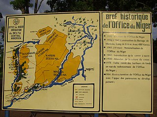
The Office du Niger is a semi-autonomous government agency in Mali that administers a large irrigation scheme in the Ségou Region of the country. Water from the Niger River is diverted into a system of canals at the Markala dam 35 kilometres (22 mi) downstream of Ségou. The water is used to irrigate nearly 100,000 hectares (390 sq mi) of the flat alluvial plains to the north and northeast of Markala that form part of the Delta mort. Although the French colonial administration constructed the system to produce cotton for the textile industry, the main agricultural product is now rice. Around 320,000 tons are grown each year representing 40 percent of the total Malian production. Large quantities of sugar cane are also grown in joint ventures between a Chinese company and the Malian state. The irrigation scheme uses 2.7 km3 (0.65 cu mi) of water each year corresponding to around 10 percent of the total flow of the Niger River.
River Manafwa is a natural river found in Eastern Uganda. The river originates from Mount Elgon in east Uganda, and traverses the districts of Bududa, Manafwa, Mbale and Butaleja. It joins the Mpologoma River, which empties into Lake Kyoga. The river basin is prone to flooding, which disrupts transportation between the Bududa and Manafwa districts, and has resulted in damage to buildings and deaths.
Yusuf Mutembuli is a Ugandan advocate of the High Court, academic, politician and member of parliament representing Butaleja District in Bunyole East constituency on the ticket of National Resistance Movement.

