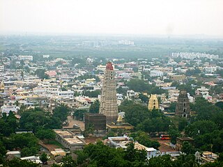
Mangalagiri is a major Sub-urban of Vijayawada in Guntur district of Indian state of Andhra Pradesh. The town is a part of Mangalagiri Tadepalli Municipal Corporation and part of Tenali revenue division. It and a part of Andhra Pradesh Capital Region. It is situated on National Highway 16 between Vijayawada and Guntur.

Krishna district is a district in the coastal Andhra Region in Indian state of Andhra Pradesh, with Machilipatnam as its administrative headquarters. It is surrounded on the East by Bay of Bengal, West by Guntur, Bapatla and North by Eluru and NTR districts and South again by Bay of Bengal.
Vijayawada, formerly known as Bezawada, is the second largest city in the Indian state of Andhra Pradesh. It is located on the banks of the Krishna River surrounded by the hills of the Eastern Ghats, known as the Indrakeeladri Hills. The city is home to the important Hindu shrine of Kanaka Durga Temple. It geographically lies on the center spot of Andhra Pradesh. The city has been described as the commercial, political, cultural and educational capital of Andhra Pradesh. It is the administrative headquarters of NTR district. The Prakasam Barrage across the Krishna River connects the NTR and Guntur districts.

Coastal Andhra or Kosta Andhra is a geographic region in the Indian state of Andhra Pradesh. Vijayawada is the largest city in this region. Region share borders with Uttarandhra, Rayalaseema and Telangana. It was part of Madras State before 1953 and Andhra State from 1953 to 1956. According to the 2011 census, it has an area of 91,915 square kilometres (35,489 sq mi) which is 57.99% of the total state area and a population of 34,193,868 which is 69.20% of Andhra Pradesh state population. This area includes the coastal districts of Andhra Pradesh on the Circar Coast between the Eastern Ghats and the Bay of Bengal, from the northern border with Odisha to Rayalaseema in the south.
Hamsaladeevi is a village in Diviseema, Koduru Mandal, Krishna District of the Indian state of Andhra Pradesh.

Machilipatnam, also known as Masulipatnam and Bandar, is a city in Krishna district of the Indian state of Andhra Pradesh. It is a municipal corporation and the administrative headquarters of Krishna district. It is also the mandal headquarters of Machilipatnam mandal in Machilipatnam revenue division of the district. The ancient port town served as the settlement of European traders from the 16th century, and it was a major trading port for the Portuguese, British, Dutch and French in the 17th century.
Gudivada is a city in Krishna district of the Indian state of Andhra Pradesh. It is a municipality and the headquarters of Gudivada mandal in Gudivada revenue division. It is one of the cities in the state to be a part of Andhra Pradesh Capital Region. It is the twenty-seventh most populous city in Andhra Pradesh and the three-hundredth most populous city in India with a population of 118,167 according to the 2011 Census of India.

Ghantasala is a village in Krishna district of the Indian state of Andhra Pradesh. It is 21 km west of Machilipatnam and 11 km east of Krishna River. The largest city of this district, Vijayawada, is around 60 km away. It is a rare and reputed center for Buddhist sculptures. Kaṇṭakasola was the ancient name of Ghantasala. It was also mentioned by Ptolemy as Kantakossyla.

Nuzvid, natively spelled Nuzividu or Nuziveedu is a city in the Eluru district of the Indian state of Andhra Pradesh. It serves as the administrative headquarters for Nuzvid mandal and Nuzvid revenue division.
Pedana is a municipality and the headquarters of Pedana mandal under Machilipatnam revenue division of Krishna district of the Indian state of Andhra Pradesh. It is located at a distance of 8 km (5.0 mi) from the district headquarters, Machilipatnam.

Hanuman Junction is a town which lies between the borders of Krishna and Eluru District of Andhra Pradesh state in India. Hanuman Junction gets its name because it is located in the X-Junction of NH-16 & AH-45.
Vuyyuru is a town in Krishna district of the Indian state of Andhra Pradesh. It is a Nagar panchayat and the headquarters of Vuyyuru Mandal. It is emerging as neighbourhood of Vijayawada, India situated 30 km away.
Kankipadu is a suburb of Vijayawada and a in Krishna District of the Indian state of Andhra Pradesh. It is also the mandal headquarters of Kankipadu mandal in Vuyyuru revenue division.
Avanigadda is a town in Krishna district of the Indian state of Andhra Pradesh. It is the mandal headquarters of Avanigadda mandal in Machilipatnam revenue division.

Kaikaluru is a town in Eluru district of the Indian state of Andhra Pradesh. Kaikalur is home to Kolleru Lake, one of the largest freshwater lakes in India, covering about 90,100 hectares and is a tourist attraction.

Mopidevi is a village in Krishna district of the Indian state of Andhra Pradesh. It is the mandal headquarters of Mopidevi mandal in Machilipatnam revenue division. It is one of the villages in the mandal to be a part of Andhra Pradesh Capital Region. The village is known for its famous Lord Subrahmanyeswar Swamy Temple. The village is situated 80Km from Vijayawada and 30Km from Machilipatnam.
Mantada is a village in Krishna district of the Indian state of Andhra Pradesh. It is located in Pamidimukkala mandal of Vuyyuru revenue division. Mantada is 31kms away from vijayawada Mantada is 37kms away from machilipatnam nearby railway stations Vijayawada Junction railway station, Gudivada Junction railway station and Machilipatnam railway station
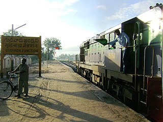
The Gudivada–Machilipatnam branch line is a railway line connecting Gudivada and Machilipatnam of Krishna district in the Indian state of Andhra Pradesh. Further, this section intersects Vijayawada–Nidadavolu loop line at Gudivada.

Tarigoppula Halt railway station is an Indian Railways station in the village of Tarigoppula of Krishna district in Andhra Pradesh. It lies on the Gudivada–Machilipatnam branch line, Vijayawada–Nidadavolu loop line and is administered under Vijayawada railway division of South Coast Railway zone.
Morusumilli also called Morusumalli is a village in Mylavaram mandal, NTR District in the Indian state of Andhra Pradesh. It belongs to Andhra region.
