Dolinsk

Last updated

Dolinsk (Russian : Долинск) is the name of several inhabited localities in Russia.

Russian language East Slavic language

Russian is an East Slavic language, which is official in the Russian Federation, Belarus, Kazakhstan and Kyrgyzstan, as well as being widely used throughout Eastern Europe, the Baltic states, the Caucasus and Central Asia. It was the de facto language of the Soviet Union until its dissolution on 25 December 1991. Although, nowadays, nearly three decades after the breakup of the Soviet Union, Russian is used in official capacity or in public life in all the post-Soviet nation-states, as well as in Israel and Mongolia, the rise of state-specific varieties of this language tends to be strongly denied in Russia, in line with the Russian World ideology.

The classification system of the types of inhabited localities in Russia, the former Soviet Union, and some other post-Soviet states has certain peculiarities compared with the classification systems in other countries.

Urban localities
Dolinsk, Sakhalin Oblast Town in Sakhalin Oblast, Russia

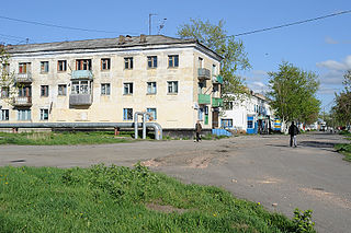
Dolinsk is a town and the administrative center of Dolinsky District of Sakhalin Oblast, Russia, located in the southeast of the Sakhalin Island in the valley of the Naiba River and its tributaries, about 45 kilometers (28 mi) north of Yuzhno-Sakhalinsk and 10 kilometers (6.2 mi) from the coast of the Terpeniye Bay of the Sea of Okhotsk. Population: 12,200 (2010 Census); 12,555 (2002 Census); 15,653 (1989 Census).

Dolinsky District District in Sakhalin Oblast, Russia

Dolinsky District is an administrative district (raion) of Sakhalin Oblast, Russia; one of the seventeen in the oblast. Municipally, it is incorporated as Dolinsky Urban Okrug. It is located in the southeast of the oblast. The area of the district is 2,441.6 square kilometers (942.7 sq mi). Its administrative center is the town of Dolinsk. Population : 13,699 (2010 Census); 15,649 (2002 Census); 22,484 (1989 Census).

Sakhalin Oblast First-level administrative division of Russia

Sakhalin Oblast is a federal subject of Russia comprising the island of Sakhalin and the Kuril Islands in the Russian Far East. The oblast has an area of 87,100 square kilometers (33,600 sq mi). Its administrative center and the largest city is Yuzhno-Sakhalinsk. Population: 497,973. Besides people from other parts of the former Soviet Union and the Korean Peninsula, the oblast is home to Nivkhs and Ainu, with the latter having lost their language in Sakhalin recently. Sakhalin is rich in natural gas and oil, and is Russia's second wealthiest federal subject. It borders Khabarovsk Krai to the west and Hokkaido, Japan to the south.

Rural localities
Krasnogvardeysky District, Orenburg Oblast District in Orenburg Oblast, Russia

Krasnogvardeysky District is an administrative and municipal district (raion), one of the thirty-five in Orenburg Oblast, Russia. It is located in the northwest of the oblast. The area of the district is 2,800 square kilometers (1,100 sq mi). Its administrative center is the rural locality of Pleshanovo. Population: 21,097. The population of Pleshanovo accounts for 16.5% of the district's total population.

Orenburg Oblast First-level administrative division of Russia

Orenburg Oblast is a federal subject of Russia. Its administrative center is the city of Orenburg. From 1938 to 1957, it bore the name Chkalov Oblast in honor of Valery Chkalov. Population: 2,033,072.

Related Research Articles

Orsk City in Orenburg Oblast, Russia

Orsk is the second largest city in Orenburg Oblast, Russia, located on the steppe about 100 kilometers (62 mi) southeast of the southern tip of the Ural Mountains. The city straddles the Ural River. Since this river is considered a boundary between Europe and Asia, Orsk can be said to lie in two continents. Population: 239,800 (2010 Census); 250,963 (2002 Census); 270,711 (1989 Census).

Yuzhno-Kurilsky District District in Sakhalin Oblast, Russia

Yuzhno-Kurilsky District is an administrative district (raion) of Sakhalin Oblast, Russia; one of the seventeen in the oblast. Municipally, it is incorporated as Yuzhno-Kurilsky Urban Okrug. It is located on the southern Kuril Islands southeast of the Island of Sakhalin, comprising the islands of Kunashir, Shikotan, and the Habomai. The area of the district is 1,856.1 square kilometers (716.6 sq mi). Its administrative center is the urban locality of Yuzhno-Kurilsk, located on the Kunashir Island. Population: 9,501 (2010 Census); 9,727 (2002 Census); 13,597 (1989 Census). The population of Yuzhno-Kurilsk accounts for 61.4% of the district's total population.

Shakhtyorsk Town in Sakhalin Oblast, Russia

Shakhtyorsk is a town in Uglegorsky District of Sakhalin Oblast, Russia, located on the western coast of the Sakhalin Island, 376 kilometers (234 mi) northwest of Yuzhno-Sakhalinsk, the administrative center of the oblast. Population: 8,382 (2010 Census); 10,643 (2002 Census); 12,945 (1989 Census).

Dolinsk-Sokol (air base) Airfield

Dolinsk-Sokol is a military air base in Sakhalin Oblast, Russia located 8 km south of Dolinsk. It is a small base with numerous hardened hangars.

The 11th Army of VVS and PVO was a formation of the Russian Air Force, which was located in the Russian Far East and Pacific Coast area, and its zone of responsibility covered the Far East Military District.

Trudovoy, Trudovaya, or Trudovoye is the name of several rural localities in Russia:

Krasnoyarsky, Krasnoyarskaya, or Krasnoyarskoye is the name of several rural localities in Russia:

Gorny, Gornaya, or Gornoye is the name of several inhabited localities in Russia.

Sol-Iletsky District District in Orenburg Oblast, Russia

Sol-Iletsky District is an administrative district (raion), one of the thirty-five in Orenburg Oblast, Russia. It is located in the south of the oblast. The area of the district is 5,100 square kilometers (2,000 sq mi). Its administrative center is the town of Sol-Iletsk,. Population: 25,424 ; 28,425 (2002 Census); 52,939 (1989 Census).

Sorochinsky District District in Orenburg Oblast, Russia

Sorochinsky District is an administrative district (raion), one of the thirty-five in Orenburg Oblast, Russia. It is located in the west of the oblast. The area of the district is 2,800 square kilometers (1,100 sq mi). Its administrative center is the town of Sorochinsk. As of the 2010 Census, the total population of the district was 14,192.

Pervomaysk is the name of several inhabited localities in Russia.

Molodyozhny, Molodyozhnaya, or Molodyozhnoye is the name of several inhabited localities in Russia.

Dombarovsky (masculine), Dombarovskaya (feminine), or Dombarovskoye (neuter) may refer to:

Yasny, Yasnaya, or Yasnoye is the name of several inhabited localities in Russia.

Roshchino is the name of several inhabited localities in Russia.

Chapayevo is the name of several rural localities in Russia.

Zelenodolsk is the name of several inhabited localities in Russia.

Udarny, Udarnaya, or Udarnoye is the name of several inhabited localities in Russia.