The Molson Brewery is a Canadian-based brewery based in Montreal and was established in 1786 by the Molson family. In 2005, Molson merged with the Adolph Coors Company to become Molson Coors.

Dundas is a community and town in Hamilton, Ontario, Canada. It is nicknamed the Valley Town because of its topographical location at the bottom of the Niagara Escarpment on the western edge of Lake Ontario. The population has been stable for decades at about 20,000, largely because it has not annexed rural land from the protected Dundas Valley Conservation Area.
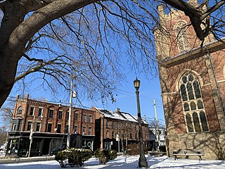
Corktown is an older residential neighbourhood in downtown Toronto, Ontario, Canada. The neighbourhood is south of Shuter Street, north of the Gardiner Expressway, east of Parliament Street, and west of Don River to the east. Corktown contains many vacated industrial buildings, some now used for movie production, and others repurposed for studios and shops. The West Don Lands development is in the south-east corner of this area.

Deer Park is a neighbourhood in Toronto, Ontario, Canada. It is centered on the intersection of Yonge Street and St. Clair Avenue and its boundaries are the Vale of Avoca section of Rosedale ravine in the east, Farnham Avenue and Jackes Avenue in the south, Avenue Road and Oriole Parkway in the west, the Beltline Trail in the north on the west side of Yonge Street, and Glen Elm Avenue in the north on the east side of Yonge Street. For the purposes of social policy analysis and research, the Toronto government’s Social Development & Administration division includes Deer Park within the City of Toronto's official "Rosedale-Moore Park" and "Yonge-St.Clair" neighbourhood profiles. The neighbourhood is in Ward 22, represented by Councillor Josh Matlow at Toronto City Council.

Front Street is an east–west road in downtown Toronto, Ontario, Canada. First laid out in 1796, the street is one of the original streets of the Town of York. The street was laid out along the shoreline of Lake Ontario as it existed during that time. It remains an important street, with many important uses located along it, including the St. Lawrence Market, Meridian Hall, Union Station and the Metro Toronto Convention Centre. The eastern section of Front Street, in the West Don Lands, east of Cherry Street, is being rebuilt as a broad tree-lined boulevard, intended to be the pedestrian-friendly commercial spine of the new neighbourhood.

Todmorden Mills was a small settlement located in the Don River valley in Toronto, Ontario. It started out as a lumber mill in the 1790s. Originally known as "Don Mills", it grew into a small industrial complex and village before becoming part of East York in the 20th century. Currently the valley site is occupied by the Todmorden Mills Heritage Museum and Arts Centre, which includes the museum, art gallery, a theatre and a forest preserve.

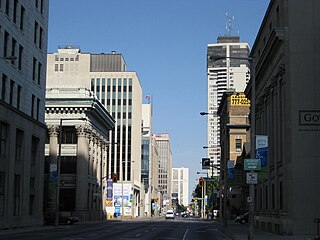
Downtown Toronto is the main central business district of Toronto, Ontario, Canada. Located entirely within the district of Old Toronto, it is approximately 16.6 square kilometres in area, bounded by Bloor Street to the northeast and Dupont Street to the northwest, Lake Ontario to the south, the Don Valley to the east, and Bathurst Street to the west. It is also the home of the municipal government of Toronto and the Government of Ontario.

Hughson Street is a Lower City collector road in Hamilton, Ontario, Canada. It starts at Charlton Avenue East at St. Joseph's hospital and runs north to Haymarket Street in the downtown where it's cut off by the Hamilton GO Transit station. Up to this point it is a two-way street. It then starts up again north of the station on Hunter Street East, where it then becomes a one-way street going north just past Barton Street East to Murray Street where it's cut off again by a parking lot for LIUNA Station. It then starts up again one block north past the CN railway tracks on Strachan Street and from this point onwards becomes a two-way street again that extends to the city's North End to the waterfront on Guise Street West, the site of the Canada Marine Discovery Centre and Pier 9.

Wellington Street is a Lower City arterial road in Hamilton, Ontario, Canada. It starts off at Charlton Avenue East as a two-way street for only one block where it's then blocked off by the Corktown Park and a couple of Canadian National Railway lines that cut through it. It then starts up again north of the park on Young Street and is a one-way street the rest of the way (Southbound). It ends in the North End of the City on Burlington Street East, in front of the Lakeport Brewing Company and the Administration offices of the Hamilton Port Authority.
Main Street is a street in Hamilton, Ontario, Canada.

The West Don Lands are the site of a neighbourhood under construction in Toronto, Ontario, Canada. The area is bordered by the Don River, King Street, Parliament Street and the rail line adjacent to the Gardiner Expressway. It is 80 hectares in size. A former industrial area, the area is being rebuilt as a mixed-use neighbourhood.

Toronto Centre is a provincial electoral district in Toronto, Ontario, Canada. Since 1999 it has elected one member to the Legislative Assembly of Ontario.
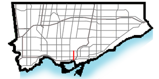
Parliament Street is a north–south street in the eastern part of downtown Toronto, Ontario, Canada. The street runs from Bloor Street to Queens Quay and is the first major street west of the Don River.

Thorncliffe Park Raceway was a Toronto-area racetrack that operated from 1917 until 1952. It was located east of Millwood Road, south of Eglinton Avenue East and the CPR's railroad tracks. It was the first home of the Prince of Wales Stakes. The name is retained today by the Thorncliffe Park neighbourhood.

Robert T. Davies was a Canadian businessman, as well as a Thoroughbred and Standardbred racehorse owner and breeder.

Enoch Turner Schoolhouse is a historic site and museum owned by the Ontario Heritage Trust. The school was built in 1848 when it was known as the Ward School. The building is located at 106 Trinity Street between King Street East and Eastern Avenue in Toronto, Ontario. Canada. It is the oldest school standing in the city.

Trefann Court is a small neighbourhood in the eastern part of downtown Toronto, Ontario, Canada. It is located on the north side of Queen Street between Parliament Street and River Street. It extends north only a short distance to Shuter St.

The Dominion Hotel is a restaurant and former hotel in Toronto, Ontario, Canada. Constructed in the late nineteenth century in the Corktown neighbourhood, it is a heritage hotel structure that has not been torn down and replaced with a modern structure. The structure is a designated heritage property.
Corktown Common is a park in the south eastern portion of the West Don Lands neighbourhood in Toronto, Ontario, Canada which opened in 2013. It borders the Don River to the east. It was built on remediated industrial lands to be the centrepiece of a new emerging neighbourhood in downtown Toronto. It also provides a barrier to flooding from the Don River.

The Dominion Brewery was a brewery in Toronto, Ontario, Canada. It operated from 1878 until 1936.

