
Don Kho is an island village in the People's Democratic Republic of Lao, located in Champasak Province. It sits in the main stream of the Mekong River upstream (northwest) of Pakse
Don Kho is an island village in the People's Democratic Republic of Lao, located in Champasak Province. It sits in the main stream of the Mekong River upstream (northwest) of Pakse

Don Kho is a small island in the Mekong River with a population of roughly 450 people. It is located several kilometres upstream from the Southern Lao city of Pakse. The villagers here depend very largely on fishing as a source of livelihood. Much of the fish is sold for cash income and used to buy other products and produce. The island is also covered in idyllic rice paddies which provide another source of food for the locals. There has been some tension on the island recently with the local district setting up a "no fishing" exclusion zone in part of the waterways, potentially impacting upon livelihoods.
Lao Airlines Flight 301 crashed near Don Kho on 16 October 2013.
There is a very small silk-weaving industry on the island, which is regarded highly for the quality of silk and the patterns produced. The island does not have electricity or running water, but tourists are welcome to visit during the day. Currently very few tourists visit this island (at times there are none for months on end) as the resources and attractions are limited. To get there one would need to pay a local boat operator some kip to take you across to the island. The islanders hope, in time, to develop a more substantial tourism industry on the island, but currently do not have the means to do so.

The island does now have electricity .
The island features a small school and surprisingly dramatic temple which was originally built by the French, now used by the Buddhist monks on the island. The temple complex also features a large bell tower which is used by the monks to signal meal times for those on the island. Now there is electricity on the Island {220 volts}
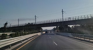
This article concerns the systems of transportation in Laos. Laos is a country in Asia, which possesses a number of modern transportation systems, including several highways and a number of airports. As a landlocked country, Laos possesses no ports or harbours on the sea, and the difficulty of navigation on the Mekong means that this is also not a significant transport route.

The Mekong or Mekong River is a trans-boundary river in East Asia and Southeast Asia. It is the world's twelfth longest river and the third longest in Asia. Its estimated length is 4,909 km (3,050 mi), and it drains an area of 795,000 km2 (307,000 sq mi), discharging 475 km3 (114 cu mi) of water annually. From the Tibetan Plateau the river runs through China, Myanmar, Laos, Thailand, Cambodia, and Vietnam. The extreme seasonal variations in flow and the presence of rapids and waterfalls in the Mekong make navigation difficult. Even so, the river is a major trade route between western China and Southeast Asia.

Stung Treng is a province of Cambodia in the northeast. It borders the provinces of Ratanakiri to the east, Mondulkiri and Kratié to the south and Kampong Thom and Preah Vihear to the west. Its northern boundary is Cambodia's international border with Laos. The Mekong River bisects the province. The province is mostly covered by forest, but logging and fishing put high pressure on the forest and fishery reserves.

Pakse is the capital and most populous city of the southern Laotian province of Champasak, making it the second most populous city in Laos. At the confluence of the Xe Don and Mekong Rivers, it has a population of about 95,000. It served as the capital of the Kingdom of Champasak until it was unified with the rest of Laos in 1946.

Nakhon Phanom province is one of Thailand's seventy-six provinces (changwat) lies in upper northeastern Thailand also called Isan. Directly adjacent provinces are : Mukdahan, Sakon Nakhon, and Bueng Kan. To the northeast it borders Khammouan of Laos.

Dams and reservoirs in Laos are the cornerstone of the Lao government's goal of becoming the "battery of Asia".

Laos developed its culture and customs as the inland crossroads of trade and migration in Southeast Asia over millennia. As of 2012 Laos has a population of roughly 6.4 million spread over 236,800 km2, yielding one of the lowest population densities in Asia. Yet the country of Laos has an official count of over forty-seven ethnicities divided into 149 sub-groups and 80 different languages. The Lao Loum have throughout the country's history comprised the ethnic and linguistic majority. In Southeast Asia, traditional Lao culture is considered one of the Indic cultures.
Khong Island or Don Khong is the largest island and the seat of administration in the Si Phan Don riverine archipelago located in the Mekong River, Khong District, Champasak Province, southern Laos.

Champasak is a small town in southern Laos, on the west bank of the Mekong River about 40 km south of Pakse, the capital of Champasak Province.

Muang Xay, also referred to as Oudomxai or Oudomxay, is the capital city of Oudomxai Province, Laos.
The Si Phan Don is a riverine archipelago in the Mekong River, Champasak Province in southern Laos. Si Phan Don is part of Khong District, including the islands and part of the mainland in the east. Si Phan Don is dotted with numerous islands, half of which are submerged when the Mekong River is in flood. The principal islands of Si Phan Don are Don Khong, Don Som, Don Det and Don Khon. Si Phan Don borders Cambodia and historical and cultural ties link the people on both side of the border. Pakse is the closest of the bigger cities in Laos to the area.

Theravada Buddhism is the largest religion in Laos. It is practiced by 66% of the population. Almost all ethnic or "lowland" Lao are followers of Theravada Buddhism; however, they constitute only 40-50% of the population. The remainder of the population belongs to at least 48 distinct ethnic minority groups. Most of these ethnic groups are practitioners of Tai folk religion, with beliefs that vary greatly among groups.

Vientiane is the capital and largest city of Laos. Vientiane is divided administratively into 9 cities with a total area of only approx. 3,920 square kilometres and is located on the banks of the Mekong, close to the Thai border. Vientiane was the administrative capital during French rule and, due to economic growth in recent times, is now the economic center of Laos. The city had a population of 948,477 as of the 2020 Census.

The Java barb, more commonly known as silver barb in aquaculture, is a species of ray-finned fish in the genus Barbonymus.
The Don Sahong is a hydroelectric dam commissioned in 2020 on the Mekong River in Siphandone area of Champasak Province, Laos, less than two kilometers upstream of the Laos–Cambodia border.
This page describes energy and electricity production, consumption and import in Laos.

Bokèo is a northern province of Laos. It is the smallest and least populous province in the country. Bokeo province covers an area of 6,196 square kilometres (2,392 sq mi). Bokeo province borders Luang Namtha province to the northeast, Oudomxai province to the east, Xaignabouli province to the south, and Thailand to the southwest and Burma to the west and northwest. The province has five districts:. It is rich in deposits of precious and semiprecious stones. Bokeo's provincial capital is Houayxay on the Mekong River. The province is in the Golden Triangle, at the border of Myanmar and Thailand. There are 34 ethnic groups in the province. Houay Xay is the border town with Thailand and regional economic centre.

Sainyabuli province is a province in northwest Laos. Sainyabuli town is the capital of the province. Sainyabuli is the only Lao province that is completely west of the Mekong River.

Champasak is a province in southwestern Laos, near the borders with Thailand and Cambodia. It is one of the three principalities that succeeded the Lao kingdom of Lan Xang. As of the 2015 census, it had a population of 694,023. The capital is Pakse, but the province takes its name from Champasak, the former capital of the Kingdom of Champasak.

Don Det, is an island in the Mekong River in the Si Phan Don archipelago in Champasak Province of southern Laos.