
The Republic of the Congo is located in the western part of central Africa, on the Equator. Congo has several important ports. The Republic of the Congo covers an area of 342,000 km², of which 341,500 km² is land while 500 km² is water. Congo claims 200 nautical miles (370 km) of territorial sea.
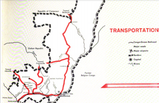
Transport in the Republic of Congo includes land, air and water modes. Over 3,000 km (1,900 mi) of paved roads are in use. The two international airports are Maya-Maya Airport and Pointe Noire Airport.
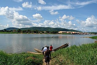
The Ubangi River, also spelled Oubangui, is a river in Central Africa, and the largest right-bank tributary of the Congo River. It begins at the confluence of the Mbomou and Uele Rivers and flows west, forming the border between Central African Republic (CAR) and the Democratic Republic of the Congo (DRC). Subsequently, the Ubangi bends to the southwest and passes through Bangui, the capital of the CAR, after which it flows south – forming the border between the DRC and the Republic of the Congo. The Ubangi finally joins the Congo River at Liranga.

Since 10 December 2020, The Central African Republic is administratively divided into 20 prefectures and the capital city of Bangui, which is an autonomous commune.

Lobaye is one of the 20 prefectures of the Central African Republic. Its capital is Mbaïki. Emperor Duy Tân of Vietnam died here on December 26, 1945 in a plane crash. David Dacko, the first and third president of the Central African Republic from 1960–1965 and 1979–1981, was from Lobaye.

Ombella-M'Poko is one of the 20 prefectures of the Central African Republic. Its capital is Boali since 10 December 2020. One important tourist attraction is the Falls of Boali; however, due to the Boali dam, the falls only carry water on the weekends.
The Chari River, or Shari River, is a 1,400 kilometres (870 mi) long river, flowing in Central Africa. It is Lake Chad's main source of water.

Likouala is a department of the Republic of the Congo in the northern part of the country. It borders the departments of Cuvette and Sangha, and internationally, the Democratic Republic of the Congo and the Central African Republic. The region has an area of 66,044 km² and an estimated population of almost 360,000. The chief town is Impfondo. Principal cities and towns include Epena and Dongou.

Bangassou is a city in the south eastern Central African Republic, lying on the north bank of the Mbomou River. It has a population of 24,447 and is the capital of the Mbomou prefecture. It is known for its wildlife, market, and nearby Bangassou Airport and is linked by ferry to the Democratic Republic of Congo on the south bank. The city is also home to the Roman Catholic Diocese of Bangassou.
Epena is a village of 2000 people, the administrative seat of Epena District in the Likouala Department of northeastern Republic of the Congo.
Impfondo is a town and a commune in the northeastern Republic of the Congo lying on the Oubangui River. It is home to an airport and is linked by river barge to Brazzaville and to Bangui. It is the administrative centre of the Likouala Department and the Impfondo District.
Carnot is a city located in the south west of the Central African Republic (CAR), in the prefecture of Mambéré.
The Departments of the Republic of the Congo are divided into 86 districts and 6 communes; which are further subdivided into urban communities and rural communities ; which are further subdivided into quarters or neighborhoods (quartiers) and villages. Note the departments of Brazzaville and Pointe-Noire are made of 1 commune each, then divided in urban districts (arrondissements).

Dongou is a district in the Likouala Department of north-eastern Republic of the Congo. The capital lies at Dongou.
Impfondo is a district in the Likouala Department of north-eastern Republic of the Congo. The capital lies at Impfondo. Impfondo is also the home of Likouala's capital.
Alphonse Gondzia is a Congolese politician who has served in the Senate of Congo-Brazzaville since 2002. He has also been President of the Senate's Judicial and Administrative Affairs Commission since 2002.
Bole, also known as Dibole or Babole, is a Bantu language spoken in the Likouala Department in the Republic of Congo. Speakers are clustered in villages on the Likouala-aux-Herbes river, south of Epena.
The 2019–2020 Congo River floods resulted from torrential rains from October 2019 to January 2020 that caused the overflow of the Congo and Ubangi rivers, floods and landslides throughout the Democratic Republic of Congo (DRC) and Republic of Congo (RoC) and led to the displacement of hundreds of thousands of people.

The Likouala-aux-Herbes is a river in the Republic of the Congo. It is a tributary of the Sangha River, which in turn is a tributary of the Congo River. It gives its name to the Likouala Department.

The Likouala-Mossaka is a river in the Republic of the Congo. It is a tributary of the Congo River, which it enters to the east of the town of Mossaka.
