Tanjung Pengelih is a small town in Pengerang, Kota Tinggi District, Johor, Malaysia. The Tanjung Pengelih historical British Military Operation Centre fortress during World War II is located here. The Royal Malaysian Naval Academy is also in Tanjung Pengelih.

Kubryk is a village in the administrative district of Gmina Krośnice, within Milicz County, Lower Silesian Voivodeship, in south-western Poland. Prior to 1945 it was in Germany.
Dzierzkowice-Góry is a village in the administrative district of Gmina Dzierzkowice, within Kraśnik County, Lublin Voivodeship, in eastern Poland.
Hołówki Duże is a village in the administrative district of Gmina Juchnowiec Kościelny, within Białystok County, Podlaskie Voivodeship, in north-eastern Poland.
Chociw is a village in the administrative district of Gmina Widawa, within Łask County, Łódź Voivodeship, in central Poland. It lies approximately 7 kilometres (4 mi) south-east of Widawa, 23 km (14 mi) south-west of Łask, and 54 km (34 mi) south-west of the regional capital Łódź.
Węże is a village in the administrative district of Gmina Działoszyn, within Pajęczno County, Łódź Voivodeship, in central Poland. It lies approximately 7 kilometres (4 mi) south-west of Działoszyn, 16 km (10 mi) south-west of Pajęczno, and 90 km (56 mi) south-west of the regional capital Łódź.
Budy is a village in the administrative district of Gmina Fałków, within Końskie County, Świętokrzyskie Voivodeship, in south-central Poland. It lies approximately 7 kilometres (4 mi) south of Fałków, 27 km (17 mi) south-west of Końskie, and 43 km (27 mi) north-west of the regional capital Kielce.
Lenartowice is a village in the administrative district of Gmina Staszów, within Staszów County, Świętokrzyskie Voivodeship, in south-central Poland. It lies approximately 9 kilometres (6 mi) south-west of Staszów and 55 km (34 mi) south-east of the regional capital Kielce.
Zalesie is a village in the administrative district of Gmina Siennica, within Mińsk County, Masovian Voivodeship, in east-central Poland. It lies approximately 3 kilometres (2 mi) west of Siennica, 11 km (7 mi) south of Mińsk Mazowiecki, and 43 km (27 mi) east of Warsaw.
Drochowo is a village in the administrative district of Gmina Naruszewo, within Płońsk County, Masovian Voivodeship, in east-central Poland.
Stobno is a village in the administrative district of Gmina Trzcianka, within Czarnków-Trzcianka County, Greater Poland Voivodeship, in west-central Poland. It lies approximately 12 kilometres (7 mi) east of Trzcianka, 22 km (14 mi) north of Czarnków, and 79 km (49 mi) north of the regional capital Poznań.
Anglity is a village in the administrative district of Gmina Pasłęk, within Elbląg County, Warmian-Masurian Voivodeship, in northern Poland. It lies approximately 7 kilometres (4 mi) north-east of Pasłęk, 23 km (14 mi) east of Elbląg, and 61 km (38 mi) north-west of the regional capital Olsztyn.
Jingyang District is a district of the city of Deyang, Sichuan Province, China.

Cikot is a village in Šumadija and Western Serbia (Šumadija), in the municipality of Rekovac, lying at 43°53′57″N21°05′23″E, at the elevation of 270 m. According to the 2002 census, the village had 277 citizens.
Suračevo is a village in the municipality of Babušnica, Serbia. According to the 2002 census, the village has a population of 444 people.
Žitni Potok is a village in the municipality of Prokuplje, Serbia. According to the 2002 census, the village has a population of 592 people.
Vojska is a village in the municipality of Svilajnac, Serbia. According to the 2002 census, the village has a population of 1050 people.
Bulakavas Manor is a former residential manor in Bulotiškė village, Lazdijai District Municipality, Lithuania.
Vranche is a village in Municipality of Dolneni, central Republic of Macedonia.
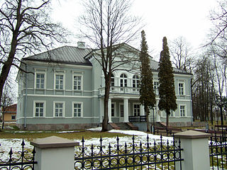
Šalčininkai Manor is a former Vagneriai residential manor in Šalčininkai city, Šalčininkai District Municipality, Lithuania.


