Dorset, Ontario

Last updated

Dorset Dorset Ontario.JPG
Dorset

Dorset is a small community located on the boundary between the Algonquin Highlands Township in Haliburton County, Ontario and Lake of Bays Municipality in Muskoka District, Canada. Dorset was originally called Cedar Narrows. In 1859 Francis Harvey became the first European settler here. Zachariah Cole mapped out the area for the government around 1860. The community name was chosen by some of the settlers that came from Dorset, England.

Contents

As of 2009, Dorset has a local permanent population of approximately 400 although these numbers increase more than tenfold in the summer months due to cottagers and vacationers.

Geography

Dorset is located within the Canadian Shield ecological region of Canada. The region has many lakes surrounded by mixed hardwood forests of predominately Sugar Maple, Red Oak, White Ash, and Yellow Birch as well as softwoods such as Eastern White Pine, Black Spruce, Eastern Hemlock, and Balsam Fir. Spruce bogs, wetlands, large granite rock outcroppings are also common in the local area.

Dorset is located on the shores of Lake of Bays between Big and Little Trading Bay. The two bodies of water are connected via the natural Dorset Channel that runs through the middle of Dorset.

History

First Nations' Chippewas of Bigwin Island made this part of Lake of Bays their summer campgrounds for years. When white settlers began moving into the area in the early 1800s, Dorset became known as Trading Bay for Francis Harvey's trading post that sprang up along the Narrows. No one knows who the first white travelers were, but someone carved 1675 into a rock in the area – found in the early 1800s by Tom Salmon, one of the first settlers on Lake of Bays. Over the years the hamlet saw an influx of loggers, timber barons, hunters and trappers, soon to be followed by settlers in 1868 taking up free grant land . While the land looked promising, as it was cleared it became apparent that the stony Canadian Shield did not lend itself well to farming. The lakes and forests were much more appealing to tourists who soon followed into the region every summer. The families of Chief Yellowhead and Chief Bigwin continued to summer in this region well into the middle of the 1900s. The town line divides the main street between Sherborne and Ridout townships. Sherborne was surveyed in 1862 by Gen. Thomas Ridout, who named it for his hometown in England. Ridout was named for the surveyor himself. The abutting ward, Franklin took its name from the great Arctic explorer who died seeking the fabled Northwest Passage. Now Sherborne is incorporated into the Algonquin Highlands, while Ridout and Franklin were encompassed into the Township of Lake of Bays. The village has a long and colourful history. Zachariah Cole, one of the surveyors on the Bobcaygeon Road, saw such promise here that he became the first settler, clearing 17 acres. When the logging boom hit, Zac Cole built a hotel and trading post on the site of an old French Trading post, complete with a whiskey still in the backyard next to a brick kiln. A driving force in developing the young village, Zac used to claim he wanted his coffin made from tamarack, because it burned with loud cracks and noises, so everyone in Hell would know he had arrived.

Transportation

Dorset is intersected by Ontario Highway 35 and Ontario Highway 117. Baysville, Bracebridge, Dwight and Huntsville are the nearest local population centers which are approximately 25, 50, 18, and 40 kilometers away, respectively.

Industry

Historically, Dorset has been primarily dependent on the forestry industry; although over the years this dependence has diminished and tourism, mainly American, European, and Japanese tourists, has taken over as the dominant contributing industry to the local economy.

Tourism

Dorset depends on tourism as a major contributor to the local economy. The summer months tend to be the busiest time of the year for the community as thousands of people from the Greater Toronto Area and abroad flock to their cottages. In autumn, many visitors also come to see the changing fall foliage in the local forests. Dorset's relatively close proximity to Algonquin Provincial Park makes it a prime spot for tourists. The community has among other amenities: Health hub, art galleries, pottery, post office, bakery, day spa, restaurants, ice cream shops, real estate brokerages, marinas, gas stations, building suppliers, bed and breakfasts, motel, as well as a general store and LCBO liquor store to name a few.

Attractions

The Dorset Scenic Look Out Tower is located on a high ridge above the community and the tower offers a panoramic view of the surrounding hills and picturesque Lake of Bays in the Muskoka / Haliburton region and is open year round; although the access road is not plowed or maintained in the winter months. The 30-metre tall tower sits 142 metres above the nearby Lake of Bays. [1] Built in 1967 on the site of the original fire tower (1922–1962), the scenic lookout is open to cars from late spring until Thanksgiving. Snowmobilers can access the tower in the winter months. The tower as well as the ridge is a dominant geographical feature in Dorset as it can be seen from almost anywhere within Dorset. (In 1963, the former Dorset Fire Tower was shown in the opening credits of the CBC TV show The Forest Rangers ).

Dorset is home to the famous Robinson's General Store, once voted "Canada's Best Country Store", owned and operated by the same family since 1921. The store was sold by the Robinson family in 2020, and was owned for 18 months by Mike Hinbest before being sold again in 2023.

Lion's Camp Dorset is a resort for Ontarians on kidney dialysis, located a few kilometres east of Dorset on Raven Lake. The resort has a dialysis unit onsite in order to provide guests in renal failure with their dialysis three times a week. [2]

The Dorset Heritage Museum is located on Main Street and features many displays about Dorset's early pioneer life, significant historical past as a major logging community. The museum is open on weekends from Victoria Day until Canada Day then Wednesday through Sunday until Thanksgiving. Entrance is by donation.

Related Research Articles

<span class="mw-page-title-main">Huntsville, Ontario</span> Town in Muskoka, Canada

Huntsville is a town in Muskoka district, Ontario. It is located 215 kilometres (134 mi) north of Toronto and 130 kilometres (81 mi) south of North Bay. Of the three major Muskoka towns (the others being Gravenhurst and Bracebridge, it is the largest in both population and land area.

<span class="mw-page-title-main">Haliburton County</span> County in Ontario, Canada

Haliburton is a county of Ontario, Canada, known as a tourist and cottage area in Central Ontario for its scenery and for its resident artists. Minden Hills is the county seat. Haliburton County and the village of Haliburton are named after Thomas Chandler Haliburton, author, statesman, and the first chairman of the Canadian Land and Emigration Company.

<span class="mw-page-title-main">District Municipality of Muskoka</span> Regional municipality in Ontario, Canada

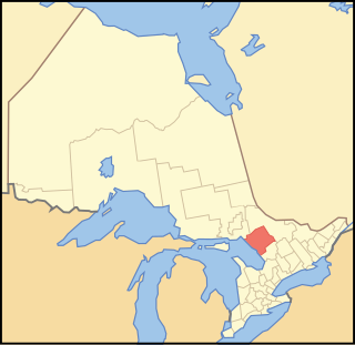
The District Municipality of Muskoka, more generally referred to as the District of Muskoka or Muskoka, is a regional municipality in Central Ontario, Canada. It extends from Georgian Bay in the west, to the northern tip of Lake Couchiching in the south, to the western border of Algonquin Provincial Park in the east. A two-hour drive north of Toronto, it spans 6,475 km2 (2,500 sq mi). It has some 1,600 lakes, making it a popular cottaging destination.

<span class="mw-page-title-main">Lake of Bays</span> Township municipality in Ontario, Canada

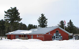
Lake of Bays is a township municipality within the District Municipality of Muskoka, Ontario, Canada. The township, situated 193 kilometres (120 mi) north of Toronto, is named after the Lake of Bays. During the 2016 census, the township had a population of 3,167 and encompassed 677.91 square kilometres (261.74 sq mi) of land.

<span class="mw-page-title-main">Parry Sound District</span> District in Ontario, Canada

Parry Sound District is a census division of the Canadian province of Ontario. Its boundaries are District of Muskoka to the south, the Sudbury District to the north-northwest, the French River and Lake Nipissing in the north, Nipissing District and North Bay in the north and east and parts of Algonquin Park in the northeast.

<span class="mw-page-title-main">Central Ontario</span> Secondary region in Ontario, Canada

Central Ontario is a secondary region of Southern Ontario in the Canadian province of Ontario that lies between Georgian Bay and the eastern end of Lake Ontario.

<span class="mw-page-title-main">Callander, Ontario</span> Canadian township established 1891

The Municipality of Callander is a township in central Ontario, Canada, located at the southeast end of Lake Nipissing in the Almaguin Highlands region of the District of Parry Sound. The municipality is located on Callander Bay, just south of North Bay.

Kearney is a town and municipality in the Almaguin Highlands region of Parry Sound District of Ontario, Canada. With a landmass of 528 square kilometres and a year-round population of 974 in the Canada 2021 Census, Kearney claims to be the "Biggest Little Town in Ontario."

<span class="mw-page-title-main">Bigwin Island</span>

Bigwin Island is an island in the municipality of Lake of Bays, District Municipality of Muskoka in Central Ontario, Canada. It the largest island on Lake of Bays.

<span class="mw-page-title-main">South River, Ontario</span> Village in Ontario, Canada

South River is a village on Highway 124 near Algonquin Park in the Almaguin Highlands region of Parry Sound District of Ontario, Canada. It is about halfway between North Bay and Huntsville or a 3-hour drive (300 km) north from Toronto. South River has access to the Algonquin Park for canoeists at Kawawaymog. South River is home of Mikisew Provincial Park on the shores of Eagle Lake.

<span class="mw-page-title-main">Dysart et al</span> United township in Ontario, Canada

The United Townships of Dysart, Dudley, Harcourt, Guilford, Harburn, Bruton, Havelock, Eyre and Clyde, commonly known as the Municipality of Dysart et al, is a municipality in Haliburton County in Central Ontario, Canada. The original townships were of the Canadian Land and Emigration Company.

<span class="mw-page-title-main">Paudash Lake</span> Glacial lake, oligotrophic, dimictic in Haliburton County, Ontario

Paudash Lake is a lake in south central Ontario southwest of Bancroft along Highway 28. The lake is located just north of Silent Lake Provincial Park in Haliburton County, 27 km (17 mi) south of the panhandle of Algonquin Provincial Park. The nearest communities to Paudash Lake are the village of Cardiff, close to the lake's Inlet Bay, and the hamlet of Paudash to the northeast of Lower Paudash Lake. Actually two lakes, 'Paudash' and 'Lower Paudash', the lakes are located on the Crowe River, near its head waters, which flows into the Trent River at Crowe Bay north of Campbellford.

King's Highway 118, commonly referred to as Highway 118, is a provincially maintained highway in the Canadian province of Ontario. The route travels across South-Central Ontario between Highway 11 near Bracebridge and Highway 28 near Bancroft. Several communities are served by the route, including Uffington, Vankoughnet, Carnarvon, West Guilford, Haliburton Village, Tory Hill, Cardiff and Paudash.

<span class="mw-page-title-main">Algonquin Highlands</span> Township in Ontario, Canada

Algonquin Highlands is a township located in Haliburton County, Ontario, Canada. It has a population of 2,351. The northeastern section of the township is included in Algonquin Provincial Park.

<span class="mw-page-title-main">Lake of Bays (Muskoka lake)</span>

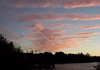
Lake of Bays is a large lake in the District Municipality of Muskoka in Central Ontario, Canada. It is located almost entirely in the Township municipality of Lake of Bays, which is named after the lake, with the exception of the southwest arm of the lake which is in the Town of Huntsville. Ontario Highway 35 runs north and east of the lake.

<span class="mw-page-title-main">Gull River (Balsam Lake)</span> River in Haliburton County, Ontario, Canada

The Gull River is a river in Algonquin Highlands and Dysart et al, Haliburton County and the single-tier municipality of Kawartha Lakes in south-central Ontario, Canada. It is in the Trent River and Lake Ontario drainage basins, and flows from southern Algonquin Provincial Park to Balsam Lake on the Trent–Severn Waterway.

<span class="mw-page-title-main">Almaguin Highlands</span> Inter-region in Ontario, Canada

The Almaguin Highlands Region in Ontario, Canada, covers approximately 5,200 km2 (2,000 sq mi) comprising the eastern half of Parry Sound District. It is bounded by Muskoka in the south, and by Lake Nipissing and Nipissing District in the north. The eastern edge abuts the western boundary of Algonquin Provincial Park, whereas the western boundary of the Almaguin Highlands is generally regarded to be the mid east-west point of Parry Sound District. Originally derived from the words Algonquin, Magnetawan, and Seguin. the name Almaguin is now used to describe the marketing region of East Parry Sound.

SS Bigwin is a small steamship ferry that plies the waters of Lake of Bays in Muskoka area of Ontario, Canada.

<span class="mw-page-title-main">Wawa Hotel</span> Building in Lake of Bays, Ontario

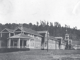
The Wawa Hotel was a large summer resort hotel located at Norway Point on Lake of Bays, in Ontario, Canada. Constructed in 1908, it was entirely destroyed by a fire on August 19, 1923. The name "Wawa" is a native Canadian word for "wild goose".

References

  1. Staff, DH Toronto (2019-03-21). "This Ontario scenic lookout tower is a must-see this spring (PHOTOS)". Daily Hive. Retrieved 2019-03-21.
  2. "Home". lionscampdorset.ca. Archived from the original on 2017-12-09. Retrieved 2017-12-08.

45°14′41″N78°53′38″W / 45.24472°N 78.89389°W / 45.24472; -78.89389