Councils of Tasmania are the 29 administrative districts of the Australian state of Tasmania. Local government areas (LGAs), more generally known as councils, are the tier of government responsible for the management of local duties such as road maintenance, town planning and waste management.

Launceston is a city in the north of Tasmania, Australia, at the junction of the North Esk and South Esk rivers where they become the Tamar River (kanamaluka). With a population of 87,328, Launceston is the second most populous city in Tasmania after the state capital, Hobart, and the fifth-largest inland city in Australia.
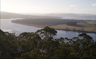
The Tamar River, officially kanamaluka / River Tamar, is a 70-kilometre (43-mile) estuary located in northern Tasmania, Australia. Despite being called a river, the waterway is a brackish and tidal estuary over its entire length.

Ben Lomond is a mountain in the north-east of Tasmania, Australia.

The North Esk River is a major perennial river located in the northern region of Tasmania, Australia.

Evandale is a historic town in northern Tasmania, Australia. It sits on the banks of the South Esk River, 18 km south of Launceston. The town is famous for its late-Georgian and early-Victorian buildings with relatively untouched streetscape, a popular Sunday market and as a host to the annual World Penny Farthing bicycle Championships. At the 2016 census, Evandale had a population of 1,345.

Lands administrative divisions of Australia are the cadastral divisions of Australia for the purposes of identification of land to ensure security of land ownership. Most states term these divisions as counties, parishes, hundreds, and other terms. The eastern states of Queensland, New South Wales, Victoria and Tasmania were divided into counties and parishes in the 19th century, although the Tasmanian counties were renamed land districts in the 20th century. Parts of South Australia (south-east) and Western Australia (south-west) were similarly divided into counties, and there were also five counties in a small part of the Northern Territory. However South Australia has subdivisions of hundreds instead of parishes, along with the Northern Territory, which was part of South Australia when the hundreds were proclaimed. There were also formerly hundreds in Tasmania. There have been at least 600 counties, 544 hundreds and at least 15,692 parishes in Australia, but there are none of these units for most of the sparsely inhabited central and western parts of the country.
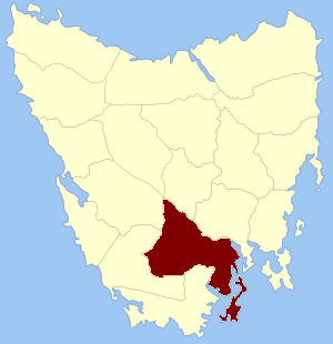
Buckingham Land District is one of the twenty land districts of Tasmania which are part of the Lands administrative divisions of Tasmania. It was formerly Buckingham County, one of the 18 counties of Tasmania and one of the first eleven proclaimed in 1836 and is bordered to the north by the River Derwent, and to the south by the Huon River. It includes Bruny Island. Hobart is located in the county. It was named after the then county of England.

Devon Land District is one of the twenty land districts of Tasmania which are part of the Cadastral divisions of Tasmania. It was formerly one of the 18 counties of Tasmania. The 1911 Encyclopædia Britannica describes Beaconsfield and Devonport as being in the county. It is bordered by the Tamar River in the east, and the Emu River near Burnie in the west. Deloraine is on the southern edge with the border with Westmoreland Land District. It is named after the English county of Devon.
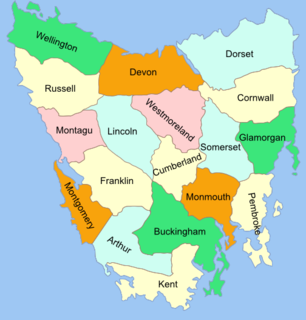
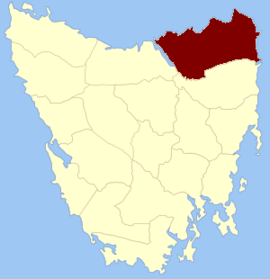
The Lands administrative divisions of Tasmania are the divisions of Tasmania into land districts and parishes for cadastral purposes, which are part of the lands administrative divisions of Australia. There are 20 land districts in Tasmania, although in the early nineteenth century there were several other systems, with 18 or 36 counties and 9 other divisions used, as well as hundreds. The land districts include the 18 former counties of the island of Tasmania which were renamed but retain the same boundaries, plus King Island and Flinders Island. The counties are referenced in the 1911 Encyclopædia Britannica, with Hobart described as being in Buckingham County, Launceston in Cornwall County and Beaconsfield in Devon County. The land districts are used for land titles today, while the Local Government Areas of Tasmania with cities and municipalities are used for political and administrative purposes.
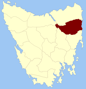
Cornwall Land District is one of the twenty land districts of Tasmania which are part of the Cadastral divisions of Tasmania. It contains most of Launceston. It was formerly Cornwall County, one of the 18 counties of Tasmania and one of the first eleven proclaimed in 1836. It was named after the then southwestern county of England.

Cumberland Land District is one of the twenty land districts of Tasmania which are part of the cadastral divisions of Tasmania. It was formerly one of the 18 counties of Tasmania. It is bordered by the River Derwent to the south, the Clyde River to the east, with Lake Sorell at the north-eastern edge. The Nive River is the boundary to the west. Part of the Shannon River is a section of the boundary to the north, with Great Lake on the northern edge.

Glamorgan Land District is one of the twenty land districts of Tasmania which are part of the Cadastral divisions of Tasmania. It was formerly one of the 18 counties of Tasmania. It is located along the eastern edge of Tasmania, from Seymour in the north, to Pontypool in the south. It includes Swansea, Bicheno, Cranbrook, and Lisdillon. It also includes the area around Great Oyster Bay, the Freycinet Peninsula and Schouten Island. The LGA of Glamorgan Spring Bay Council is in a similar region.

Kent Land District is one of the twenty land districts of Tasmania which are part of the Cadastral divisions of Tasmania. It was formerly one of the 18 counties of Tasmania. It is located on the southern tip of Tasmania. It is bordered by the Huon River to the north, and Picton River to the north-west. It includes Dover, Geeveston and Southport, and part of the Southwest National Park.

Monmouth Land District is one of the twenty land districts of Tasmania which are part of the cadastral divisions of Tasmania. It was formerly one of the 18 counties of Tasmania. It is bordered by the River Derwent to the south, the Clyde River to the west, and a small part of the Jordan River to the north.
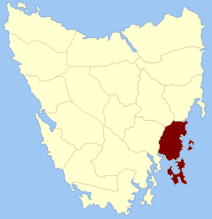
Pembroke Land District is one of the twenty land districts of Tasmania which are part of the cadastral divisions of Tasmania. It was formerly one of the 18 counties of Tasmania. It includes Tasman Peninsula and Port Arthur, as well as Forestier Peninsula, Dodges Ferry and Maria Island. The Electoral division of Pembroke is not actually within the land district, but is close by in Monmouth.
Garden Island is a small stony island that is part of the Partridge Island Group, lying close to the south-eastern coast of Tasmania, Australia, in the D'Entrecasteaux Channel between Bruny Island and the mainland. The D'Entrecasteaux Channel is the mouth for the Huon River.

Somerset Land District is one of the twenty land districts of Tasmania which are part of the Cadastral divisions of Tasmania. It was formerly one of the 18 counties of Tasmania.

Westmoreland Land District is one of the twenty land districts of Tasmania which are part of the Cadastral divisions of Tasmania. It was formerly one of the 18 counties of Tasmania.
In the Australian state of Tasmania, there are many areas which are commonly known by regional names. Regions are areas that share similar characteristics. These characteristics may be natural such as the Furneaux Islands, the coastline, or the Central Highlands. Alternatively, the characteristics may be cultural, such as a viticulture land use. Tasmania is divided by numerous regional boundaries, based on different characteristics. In many cases boundaries defined by different government agencies are coterminous and are often cited by the Australian and local media that tend to distinguish between North West, West Coast, Southern, and East Coast.